|
Manuscripts |
MS 726/167 |
Records of CFA Archaeology Ltd, archaeologists, Musselburgh, East Lothian, Scotland |
Coastal Assessment Survey: Inner Moray Firth, Volumes 1 and 2. |
14/12/1998 |
Item Level |
|
|
Manuscripts |
MS 2776/1/9 |
Historic Scotland Archive Project |
Survey archive: Site record sheets, site record sheets with field notes and monument forms from the Inner Moray Firth (Moray, Beauly and Cromarty Firth) Coastal Assessment Survey. Sheet 9. |
9/1998 |
Item Level |
|
|
Prints and Drawings |
BD 104/1/9 |
Historic Scotland Archive Project |
Survey archive: 1:25,000 OS Pathfinder map depicting site locations from the Moray, Beauly and Cromarty Firth Coastal Assessment Survey. Sheet 9. |
9/1998 |
Item Level |
|
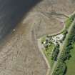 |
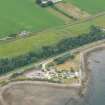
On-line Digital Images |
DP 191599 |
RCAHMS Aerial Photography Digital |
Oblique aerial view of Foulis Point, looking SSW. |
18/6/2014 |
Item Level |
|
 |
On-line Digital Images |
DP 191600 |
RCAHMS Aerial Photography Digital |
Oblique aerial view of Foulis Point, looking SSW. |
18/6/2014 |
Item Level |
|
 |
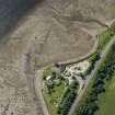
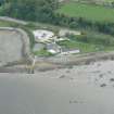
On-line Digital Images |
DP 191649 |
RCAHMS Aerial Photography Digital |
Oblique aerial view of the fish traps, looking NW. |
18/6/2014 |
Item Level |
|
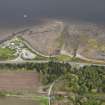 |
On-line Digital Images |
DP 211990 |
RCAHMS Aerial Photography Digital |
Oblique aerial view of the fish traps at Foulis Ferry, looking SE. |
13/5/2015 |
Item Level |
|
 |
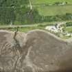
On-line Digital Images |
DP 340616 |
Papers of James Sloan Bone, landscape historian, Inverness, Highland, Scotland |
General aerial view of Foulis Ferry on the Cromarty Firth, looking N. |
9/7/2006 |
Item Level |
|
 |
On-line Digital Images |
DP 341379 |
Papers of James Sloan Bone, landscape historian, Inverness, Highland, Scotland |
Oblique aerial view of Foulis Ferry Granary, N shore of Cromarty Firth, looking W. |
19/5/2008 |
Item Level |
|
 |
On-line Digital Images |
SC 2363051 |
Records of the Ordnance Survey, Southampton, Hampshire, England |
Foulis Ferry, NH56SE 25, Ordnance Survey index card, Recto |
c. 1958 |
Item Level |
|


