
Pricing Change
New pricing for orders of material from this site will come into place shortly. Charges for supply of digital images, digitisation on demand, prints and licensing will be altered.
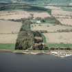
Foulis, Cnoc An Teampuill


Burial Cairn (Prehistoric)(Possible), Burial Ground (Medieval)(Possible), Chapel (Medieval)
Site Name Foulis, Cnoc An Teampuill
Classification Burial Cairn (Prehistoric)(Possible), Burial Ground (Medieval)(Possible), Chapel (Medieval)
Alternative Name(s) Churchyard Field
Canmore ID 12897
Site Number NH56SE 11
NGR NH 5877 6368
Datum OSGB36 - NGR
Permalink http://canmore.org.uk/site/12897


- Council Highland
- Parish Kiltearn
- Former Region Highland
- Former District Ross And Cromarty
- Former County Ross And Cromarty
NH56SE 11 5877 6367.
(NH 5877 6367) Cnoc an Teampuill (NR)
OS 1:10,000 map, (1971)
Cnoc an Teampuill is an old burial ground, but there is no tradition of a church.
Name Book 1875.
Cnoc an Teampuill (name verified) consists of an oval stony mound, overgrown with nettles, which is situated in an arable field on a gentle SE facing slope. It measures 21.0m E-W by 18.0m N-S and is 1.5m high. Stones cleared from the adjoining fields have been piled onto the mound, these include a numher of large slab-like stones now lying on the surface of the mound.
The field is called Churchyard Field, and the burial ground tradition still survives, but there is considerable doubt as to its classification. No information regarding a church or chapel can be found, and the feature is undoubtedly 'mound-like', though this effect is accentuated by ploughing to its base, and the addition of unknown quantities of stone clearance. On balance it is more likely to be a burial cairn.
Visited by OS (N K B) 20 December 1976.

