
Following the launch of trove.scot in February 2025 we are now planning the retiral of some of our webservices. Canmore will be switched off on 24th June 2025. Information about the closure can be found on the HES website: Retiral of HES web services | Historic Environment Scotland
Rossie Drain


Timber Structure (Period Unassigned)
Site Name Rossie Drain
Classification Timber Structure (Period Unassigned)
Canmore ID 128941
Site Number NO20NE 239
NGR NO 281 098
Datum OSGB36 - NGR
Permalink http://canmore.org.uk/site/128941


- Council Fife
- Parish Collessie
- Former Region Fife
- Former District North East Fife
- Former County Fife
NO20NE 239 281 098
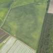
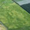
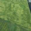
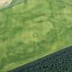
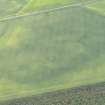
The cropmarks of a segmented timber structure have been recorded from aerial photographs (RCAHMSAP 1994) situated in a field W of Heatherhall Wood, and approximately 50m SW of the enclosure (NO02NE 31) recorded at NO 2815 0987. A possible mortuary structure, the rectilinear cropmarks are approximately 30m in length and roughly 15m wide with a slightly tapering NE end. The cropmarks of a possible house have also been detected, just to the SE of the timber structure at NO c. 2815 0980.
Information from RCAHMS (JH) 16 April 1998.

