
Ardnagrask


Enclosure (Prehistoric), Sunken Floored Building (Prehistoric)(Possible)
Site Name Ardnagrask
Classification Enclosure (Prehistoric), Sunken Floored Building (Prehistoric)(Possible)
Canmore ID 12688
Site Number NH54NW 29
NGR NH 52270 49406
Datum OSGB36 - NGR
Permalink http://canmore.org.uk/site/12688


- Council Highland
- Parish Urray (Ross And Cromarty)
- Former Region Highland
- Former District Ross And Cromarty
- Former County Ross And Cromarty
Field Visit (January 1978)
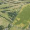
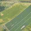
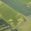
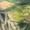
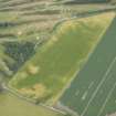
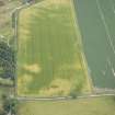
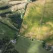
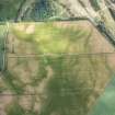
Ardnagrask NH 522 494 NH54NW
Air photographs show the crop-marks (in a field 150m EN E of Ardnagrask Mains farmhouse) of what appears to be the site of a circular timber house situated within an oval enclosure formed by a narrow ditch and measuring about 22m by 18m.
RCAHMS 1979, visited January 1978

