Accessibility

Font Size

100% 150% 200%

Background Colour

Default Contrast
Close Reset

Ardnagrask

Barrow (Prehistoric)(Possible), Ring Ditch (Prehistoric)

Site Name Ardnagrask

Classification Barrow (Prehistoric)(Possible), Ring Ditch (Prehistoric)

Canmore ID 12687

Site Number NH54NW 28

NGR NH 5245 4909

Datum OSGB36 - NGR

Permalink http://canmore.org.uk/site/12687

Ordnance Survey licence number AC0000807262. All rights reserved.
Canmore Disclaimer. © Bluesky International Limited 2025. Public Sector Viewing Terms

Toggle Aerial | View on large map

Digital Images

Oblique aerial view.
Oblique aerial view.Oblique aerial view.Oblique aerial view of the cropmarks of the barrow, looking to the NNW.Ardnagrask, oblique aerial view, taken from the NE, centred on the cropmark of a ring-ditch.Oblique aerial view.Ardnagrask, NH54NW 28, Ordnance Survey index card, RectoArdnagrask, oblique aerial view, taken from the NW, centred on the cropmark of a ring-ditch.Oblique aerial view.Aerial view of Lower Ardnagrask, The Cairns and Muir of Ord Industrial Estate with various cropmarks, Black Isle, looking SE.Oblique aerial view of the cropmarks of the barrow, looking to the NNW.Ardnagrask, oblique aerial view, taken from the NW, centred on the cropmark of a ring-ditch.Oblique aerial view.Ardnagrask, NH54NW 28, Ordnance Survey index card, page number 1, RectoOblique aerial view.Oblique aerial view.Oblique aerial view.

Administrative Areas

  • Council Highland
  • Parish Urray (Ross And Cromarty)
  • Former Region Highland
  • Former District Ross And Cromarty
  • Former County Ross And Cromarty

Archaeology Notes

NH54NW 28 524 490.

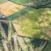
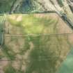
NH 524 490. Air photography has revealed the crop-mark of a ring-ditch 450 m SE of Ardnagrask Mains farmhouse; it measures about 12 m in diameter. (Visible on RCAHMS air photograph RC 1801-3, flown 1977).

RCAHMS 1979

Further aerial photographs have been taken of this enclosure. It is possible that there is an entrance in the N. Various linear features and pits are visible across the field, though they may be geomorphological rather than man-made. (See Archive for details.)

Information from J Harden 1989.

Activities

Field Visit (January 1978)

Ardnagrask NH 524 490 NH54NW

Air photography has revealed the crop-mark of a ring-ditch 450m SE of Ardnagrask Mains farmhouse; it measures about 12m in diameter.

RCAHMS 1979, visited January 1978

References

MyCanmore Image Contributions


Contribute an Image

MyCanmore Text Contributions