
Windhill


Enclosure (Prehistoric)(Possible)
Site Name Windhill
Classification Enclosure (Prehistoric)(Possible)
Canmore ID 12677
Site Number NH54NW 19
NGR NH 5341 4852
Datum OSGB36 - NGR
Permalink http://canmore.org.uk/site/12677


- Council Highland
- Parish Urray (Ross And Cromarty)
- Former Region Highland
- Former District Ross And Cromarty
- Former County Ross And Cromarty
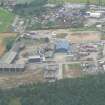
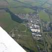
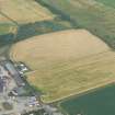
The cropmarks of the enclosure is situated in an area of industrial development, as stated above, and is not visible on the most recent oblique aerial photographs (RCAHMSAP 1995). (See NH54NW 21 for photographs).
Information from RCAHMS (KJ) 11 June 1999.
Field Visit (January 1978)
Windhill 2 NH 534 485 NH54NW
Air photography has revealed the crop-marks of what may be the NW side and parts of the NE and SW sides of a rectangular enclosure about 600m NNE of Tomich House in an area now under development as an industrial estate.
RCAHMS 1979, visited January 1978

