
Pricing Change
New pricing for orders of material from this site will come into place shortly. Charges for supply of digital images, digitisation on demand, prints and licensing will be altered.
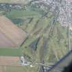
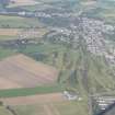
Forest Hill


Motte (Medieval)(Possible), Natural Feature (Period Unknown)
Site Name Forest Hill
Classification Motte (Medieval)(Possible), Natural Feature (Period Unknown)
Alternative Name(s) Muir Of Ord
Canmore ID 12669
Site Number NH54NW 11
NGR NH 5250 4980
Datum OSGB36 - NGR
Permalink http://canmore.org.uk/site/12669


- Council Highland
- Parish Urray (Ross And Cromarty)
- Former Region Highland
- Former District Ross And Cromarty
- Former County Ross And Cromarty
NH54NW 11 5250 4980.
At NH 52504980 is an oval mound 13-15ft. high, and measuring 107ft. E-W x 73ft N-S overall. The base of the mound, which may be at least partly natural, is surrounded by a ditch and an outer bank, the latter being about 12ft. wide and averaging 2ft. high. The flat top of the mound measures 40ft x 22ft.
It would appear to be a motte.
Information from A A Woodham to OS 8 June 1965
As described above, but it is probably a natural mound with tree-ring around the base and not a motte.
Visited by OS (A C) 20 July 1965
Omitted from Black Isle List
Accepted as motte.
P A Yeoman 1988.
Archaeological Evaluation (2004)
NH 524 498 Desk-based assessment, archaeological field evaluation and monitoring of site stripping were carried out on a site adjoining a mound recorded as a possible motte (NH54NW 11). No evidence was found of either Neolithic or medieval activity. The site appears to be a natural feature, accentuated by ploughing and the dumping of field clearance stones in the 19th and 20th centuries.
Sponsors: Mr & Mrs Urquhart.
J Wood 2004

