
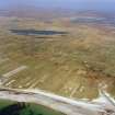
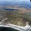
South Uist, South Boisdale


Smithy (Period Unassigned), Township (Period Unassigned)
Site Name South Uist, South Boisdale
Classification Smithy (Period Unassigned), Township (Period Unassigned)
Alternative Name(s) South Uist, Leth Meadhanach
Canmore ID 126015
Site Number NF71NW 15
NGR NF 7449 1709
NGR Description Centred NF 7449 1709
Datum OSGB36 - NGR
Permalink http://canmore.org.uk/site/126015


- Council Western Isles
- Parish South Uist
- Former Region Western Isles Islands Area
- Former District Western Isles
- Former County Inverness-shire
NF71NW 15.00 centred on 7449 1709
A crofting township comprising forty-nine roofed buildings, one of which is annotated as a Smithy, four partially roofed and twenty unroofed buildings is depicted on the 1st edition of the OS 6-inch map (Inverness-shire, Hebrides, South Uist 1881, sheet lvii).
Thirty-two roofed, three partially roofed and thirty-seven unroofed buildings are shown on the current edition of the OS 1:10000 map (1971).
Information from RCAHMS (SAH) 22 May 1997
NF71NW 15.01 centred NF7430 1722 Byre

