
Pricing Change
New pricing for orders of material from this site will come into place shortly. Charges for supply of digital images, digitisation on demand, prints and licensing will be altered.
Croick


Broch (Iron Age)(Possible)
Site Name Croick
Classification Broch (Iron Age)(Possible)
Canmore ID 12496
Site Number NH49SE 1
NGR NH 4564 9143
Datum OSGB36 - NGR
Permalink http://canmore.org.uk/site/12496


- Council Highland
- Parish Kincardine (Sutherland)
- Former Region Highland
- Former District Sutherland
- Former County Ross And Cromarty
NH49SE 1 4564 9143.
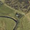
At NH 4564 9143, immediately SW. of the church at Croick, there is a much-robbed broch constructed of un- usually large unhewn boulders. The inner and outer wall-faces can be traced intermittently giving an overall diameter of c.18.4m over walling 4.3m in thickness. Within the wall in the S. arc are traces of a medial (?stabilising) wall. No evidence of an entrance can now be seen.
A line of rough boulders some 5.5m distant from the broch on the N. and SW. sides may be the remains of an outwork. Elsewhere it has been destroyed by ploughing or obscured by field clearance.
Surveyed at 1/2500.(Visited by OS (W D J) 24 May 1963)
Visited by OS (N K B) 2 October 1969; J Anderson 1890; A Graham 1949
Broch (NR)
OS 1/10,000 map, (1971)
No change to previous field report.
Visited by OS (J M) 24 November 1976
Field Visit (11 September 1943)
This site was recorded as part of the RCAHMS Emergency Survey, undertaken by Angus Graham and Vere Gordon Childe during World War 2. The project archive has been catalogued during 2013-2014 and the material, which includes notebooks, manuscripts, typescripts, plans and photographs, is now available online.
Information from RCAHMS (GF Geddes) 4 December 2014.
Publication Account (2007)
NH49 2 CROICK
NH/4564 9143
Probable broch in Kincardine made of large boulders and which has been much robbed [1]. The inner and outer faces can be traced here and there and suggest an overall diameter of about 18.4m over a wall 4.3m thick. Within the wall on the south side are traces of a wallface, presumably for the stabilisation of the rubble core.
Source: 1. NMRS site no. NH 49 SE 1: 2.
E W MacKie 2007

