
Edinburgh, Fountainbridge, General


General View (Period Unassigned)
Site Name Edinburgh, Fountainbridge, General
Classification General View (Period Unassigned)
Canmore ID 124726
Site Number NT27SW 959
NGR NT 24811 73061
Datum OSGB36 - NGR
Permalink http://canmore.org.uk/site/124726
Ordnance Survey licence number AC0000807262. All rights reserved.
Canmore Disclaimer.
© Bluesky International Limited 2025. Public Sector Viewing Terms
- Correction
- Favourite

DP 193046
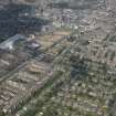
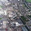
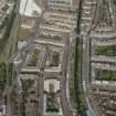
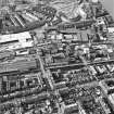
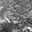
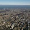
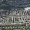
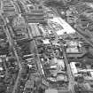
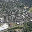
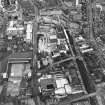
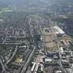
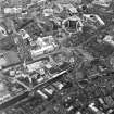
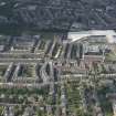
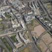
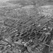
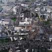
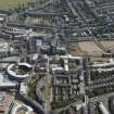
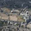
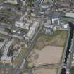
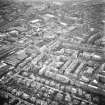
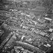
General oblique aerial view of the Fountainbridge and Merchiston areas of Edinburgh, looking NNE.
RCAHMS Aerial Photography Digital
11/7/2014
© Crown Copyright: HES

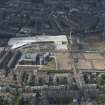
SC 1677128
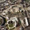
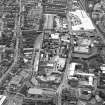
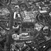
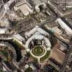
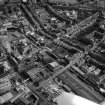
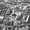
Oblique aerial view of Edinburgh centred on the Scottish Widows office building, Morrison Street, with the EICC and the construction of Exchange Crescent in the background, taken from the S.
RCAHMS Aerial Photography
28/4/1999
© Crown Copyright: HES

SC 1677273
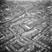
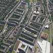
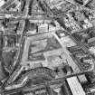
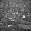
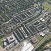
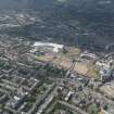
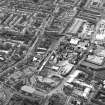
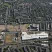
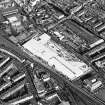
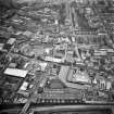
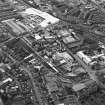
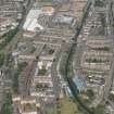
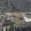
Oblique aerial view of Edinburgh centred on Fountainbridge, taken from the SSW.
RCAHMS Aerial Photography
1991
© Crown Copyright: HES

SC 1677328
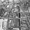
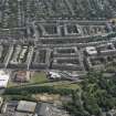
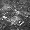
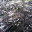
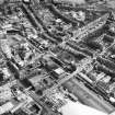
Oblique aerial view of Edinburgh centred on the Fountain Brewery and the Union Canal, taken from the SW.
RCAHMS Aerial Photography
28/4/1999
© Crown Copyright: HES

SC 1677417
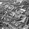
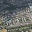
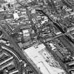
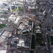
Oblique aerial view centred on the brewery with the leisure centre and cinema, canal, canal basin and canal bridge adjacent, taken from the W.
RCAHMS Aerial Photography
14/5/2003
© Crown Copyright: HES

SC 1677436
Oblique aerial view centred on the brewery with the leisure centre and cinema, canal, canal basin and canal bridge adjacent, taken from the NE.
RCAHMS Aerial Photography
14/5/2003
© Crown Copyright: HES

DP 089100
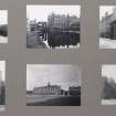
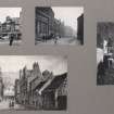
Card folder containing photographs of Union Canal, Ponton Sttreet and Fountainbridge. Front cover has pencil notes describing the photographs inside. Edinburgh Photographic Society Survey of Edinburgh District, Ward XIV George Square.
Records of Edinburgh Photographic Society, Edinburgh, Scotland
1914
© Courtesy of HES (Edinburgh Photographic Society Collection)

DP 193061
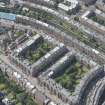
General oblique aerial view of the Union Canal and the Fountainbridge and Merchiston areas of Edinburgh, looking SSW.
RCAHMS Aerial Photography Digital
11/7/2014
© Crown Copyright: HES

DP 193064
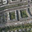
Oblique aerial view of the Union Canal and Fountainbridge, looking ENE.
RCAHMS Aerial Photography Digital
11/7/2014
© Crown Copyright: HES

DP 193068
General oblique aerial view of the Union Canal and the Fountainbridge and Merchiston areas of Edinburgh, looking NW.
RCAHMS Aerial Photography Digital
11/7/2014
© Crown Copyright: HES

DP 193073
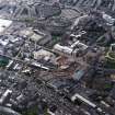
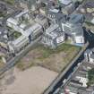
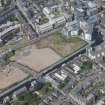
General oblique aerial view of Fountainbridge, Union Canal, Lochrin Basin and Edinburgh Quay, looking ENE.
RCAHMS Aerial Photography Digital
11/7/2014
© Crown Copyright: HES

DP 195095
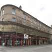
General view of 97-115 Fountainbridge, Edinburgh, taken from the north-east.
Records of the Royal Commission on the Ancient and Historical Monuments of Scotland (RCAHMS), Edinbu
13/8/2014
© Crown Copyright: HES

DP 195102
General view of Fountainbridge, Edinburgh, taken from the north-west.
Records of the Royal Commission on the Ancient and Historical Monuments of Scotland (RCAHMS), Edinbu
13/8/2014
© Crown Copyright: HES

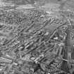
SC 1438289
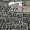
Fountainbridge area Edinburgh, Midlothian, Scotland. Oblique aerial photograph taken facing North/West.
Aero Pictorial
11/8/1954
© Courtesy of HES (Aero Pictorial Collection)

DP 247356
Oblique aerial view.
Historic Environment Scotland
26/1/2017
© Crown Copyright: HES

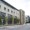
DP 260105
View of student accommodation at IQ Fountainbridge, 114 Dundee Street, Edinburgh, from south-west
Records of the Royal Commission on the Ancient and Historical Monuments of Scotland (RCAHMS), Edinbu
30/8/2017
© Crown Copyright: HES

SC 1677244
Oblique aerial view of Edinburgh centred on Fountainbridge, taken from WSW.
RCAHMS Aerial Photography
1989
© Crown Copyright: HES

SC 1677331
Oblique aerial view of Edinburgh centred on the Fountain Brewery, Fountainbridge, taken from the SSE.
RCAHMS Aerial Photography
28/4/1999
© Crown Copyright: HES

SC 1677332
Oblique aerial view of Edinburgh centred on the Fountain Brewery, Fountainbridge, taken from the SE.
RCAHMS Aerial Photography
28/4/1999
© Crown Copyright: HES

SC 1677420
Oblique aerial view centred on the brewery with the canal, canal basin and canal bridge adjacent, taken from the SE.
RCAHMS Aerial Photography
14/5/2003
© Crown Copyright: HES

SC 1677430
Oblique aerial view centred on the brewery with the canal, canal basin and canal bridge adjacent, taken from the WNW.
RCAHMS Aerial Photography
14/5/2003
© Crown Copyright: HES

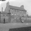
SC 409267
Fountain House and South gateway to Dalry House, Fountainbridge, Edinburgh. Demolished 1934. Area around NT 242 728.
Collection of photographs by George Chrystal and Francis Maxwell Chrystal, photographers, Edinburgh,
c. 1900
© Courtesy of HES (Francis M Chrystal Collection)

SC 1075716
Oblique aerial view of Edinburgh centred on Fountainbridge.
RCAHMS Aerial Photography
1991
© Crown Copyright: HES

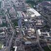
DP 038474
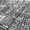
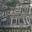
General oblique aerial view centred on the Fountainbridge district, taken from the SW.
RCAHMS Aerial Photography Digital
12/2/2008
© Crown Copyright: HES

DP 193048
General oblique aerial view of the Fountainbridge and Merchiston areas of Edinburgh, looking NW.
RCAHMS Aerial Photography Digital
11/7/2014
© Crown Copyright: HES

DP 193062
General oblique aerial view of the Union Canal and the Fountainbridge and Merchiston areas of Edinburgh, looking S.
RCAHMS Aerial Photography Digital
11/7/2014
© Crown Copyright: HES

DP 195100
General view of 125-135 Fountainbridge, Edinburgh, taken from the south-west.
Records of the Royal Commission on the Ancient and Historical Monuments of Scotland (RCAHMS), Edinbu
13/8/2014
© Crown Copyright: HES

DP 195105
General view of 185-209 Fountainbridge, and North British Rubber Works, Gilmore Park, Edinburgh, from the north-west
Records of the Royal Commission on the Ancient and Historical Monuments of Scotland (RCAHMS), Edinbu
13/8/2014
© Crown Copyright: HES

SC 1677298
Oblique aerial view of Edinburgh centred on Fountainbridge, taken from the S.
RCAHMS Aerial Photography
1993
© Crown Copyright: HES

SC 1677435
Oblique aerial view centred on the brewery with the leisure centre and cinema, canal, canal basin and canal bridge adjacent, taken from the ENE.
RCAHMS Aerial Photography
14/5/2003
© Crown Copyright: HES

SC 1677879
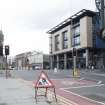
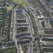
Edinburgh, oblique aerial view taken from the NW, centred on Lothian Road.
RCAHMS Aerial Photography
9/7/1996
© Crown Copyright: HES

DP 193052
General oblique aerial view of the Union Canal and the Fountainbridge and Viewforth areas of Edinburgh, looking WNW.
RCAHMS Aerial Photography Digital
11/7/2014
© Crown Copyright: HES

DP 193057
General oblique aerial view of the Fountainbridge and Merchiston areas of Edinburgh, looking SE.
RCAHMS Aerial Photography Digital
11/7/2014
© Crown Copyright: HES

DP 193063
General oblique aerial view of the Union Canal and the Fountainbridge and Merchiston areas of Edinburgh, looking SSE.
RCAHMS Aerial Photography Digital
11/7/2014
© Crown Copyright: HES

DP 193076
General oblique aerial view of Fountainbridge, Union Canal, Lochrin Basin and Edinburgh Quay, looking NNE.
RCAHMS Aerial Photography Digital
11/7/2014
© Crown Copyright: HES

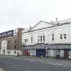
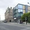
DP 195098
General view of Coliseum, 125 Fountainbridge, Edinburgh, taken from the north-west.
Records of the Royal Commission on the Ancient and Historical Monuments of Scotland (RCAHMS), Edinbu
13/8/2014
© Crown Copyright: HES

DP 195101
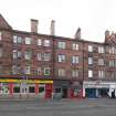
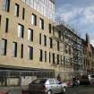
General view of Fountainbridge, Edinburgh, taken from the north-west
Records of the Royal Commission on the Ancient and Historical Monuments of Scotland (RCAHMS), Edinbu
13/8/2014
© Crown Copyright: HES

DP 195103
General view of Fountainbridge, Edinburgh, taken from the north-east.
Records of the Royal Commission on the Ancient and Historical Monuments of Scotland (RCAHMS), Edinbu
13/8/2014
© Crown Copyright: HES

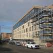
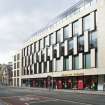
DP 260099
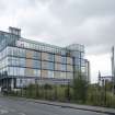
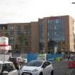
View of Hampton by Hilton, 166 Fountainbridge, Edinburgh, from south-west
Records of the Royal Commission on the Ancient and Historical Monuments of Scotland (RCAHMS), Edinbu
30/8/2017
© Crown Copyright: HES

SC 1677329
Oblique aerial view of Edinburgh centred on the Fountain Brewery and the Union Canal, taken from the SSW.
RCAHMS Aerial Photography
28/4/1999
© Crown Copyright: HES

SC 1677353
Oblique aerial view of Edinburgh centred on Fountainbridge, taken from the W.
RCAHMS Aerial Photography
1983
© Crown Copyright: HES

SC 1677416
Oblique aerial view centred on the brewery with the leisure centre and cinema, canal, canal basin and canal bridge adjacent, taken from the ENE.
RCAHMS Aerial Photography
14/5/2003
© Crown Copyright: HES

SC 1677431
Oblique aerial view centred on the brewery with the canal, canal basin and canal bridge adjacent, taken from the WSW.
RCAHMS Aerial Photography
14/5/2003
© Crown Copyright: HES

SC 1677437
Oblique aerial view centred on the brewery with the canal, canal basin and canal bridge adjacent, taken from the NNE.
RCAHMS Aerial Photography
14/5/2003
© Crown Copyright: HES

SC 1677878
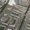
Edinburgh, oblique aerial view taken from the SE, centred on Lothian Road.
RCAHMS Aerial Photography
9/7/1996
© Crown Copyright: HES

DP 193047
General oblique aerial view of the Fountainbridge and Merchiston areas of Edinburgh, looking NW.
RCAHMS Aerial Photography Digital
11/7/2014
© Crown Copyright: HES

DP 193053
General oblique aerial view of the Union Canal and the Fountainbridge and Viewforth areas of Edinburgh, looking WSW.
RCAHMS Aerial Photography Digital
11/7/2014
© Crown Copyright: HES

DP 193056
Oblique aerial view of Fountainbridge, Edinburgh, looking SE.
RCAHMS Aerial Photography Digital
11/7/2014
© Crown Copyright: HES

DP 193059
General oblique aerial view of the Union Canal and the Fountainbridge and Merchiston areas of Edinburgh, looking WNW.
RCAHMS Aerial Photography Digital
11/7/2014
© Crown Copyright: HES

DP 193066
Oblique aerial view of the Union Canal and Fountainbridge, looking NW.
RCAHMS Aerial Photography Digital
11/7/2014
© Crown Copyright: HES

DP 195096
General view of 97-115 Fountainbridge, Edinburgh, taken from the north-east.
Records of the Royal Commission on the Ancient and Historical Monuments of Scotland (RCAHMS), Edinbu
13/8/2014
© Crown Copyright: HES

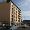
DP 195104
General view of Fountainbridge, Edinburgh, taken from the north-west.
Records of the Royal Commission on the Ancient and Historical Monuments of Scotland (RCAHMS), Edinbu
13/8/2014
© Crown Copyright: HES

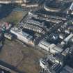
DP 232786
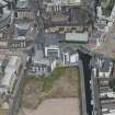
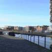
General view across Lochrin Basin and Union Canal towards Fountainbridge, Edinburgh, from south-east
Records of the Royal Commission on the Ancient and Historical Monuments of Scotland (RCAHMS), Edinbu
15/2/2015
© Crown Copyright: HES

SC 1677097
Oblique aerial view of Edinburgh centred on the Fountain Brewery and the Union Canal, taken from the SSW.
RCAHMS Aerial Photography
28/4/1999
© Crown Copyright: HES

SC 1677212
Oblique aerial view centred on the brewery with the canal, canal basin and canal bridge adjacent, taken from the SSW.
RCAHMS Aerial Photography
14/5/2003
© Crown Copyright: HES

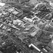
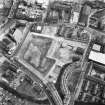
SC 1677325
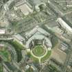
Oblique aerial view of Edinburgh centred on the construction of the Fountain Park Leisure Centre, taken from the WNW.
RCAHMS Aerial Photography
28/4/1999
© Crown Copyright: HES

SC 1677326
Oblique aerial view of Edinburgh centred on the construction of the Fountain Park Leisure Centre, taken from the W.
RCAHMS Aerial Photography
28/4/1999
© Crown Copyright: HES

SC 1677327
Oblique aerial view of Edinburgh centred on the Fountain Brewery, taken from the W.
RCAHMS Aerial Photography
28/4/1999
© Crown Copyright: HES

SC 409261
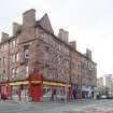
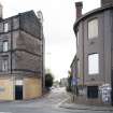
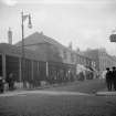
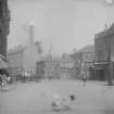
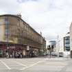
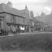
Fountainbridge, Edinburgh at NTNT2476 7304, opposite the Clachan public house which is still at the corner of Thornybauk and Fountainbridge. General view of street.
Collection of photographs by George Chrystal and Francis Maxwell Chrystal, photographers, Edinburgh,
1900
© Courtesy of HES (Francis M Chrystal Collection)

SC 409262
View of Fountainbridge, Edinburgh including Palais de Danse (on site of iron foundry and saw mill). The buildings in the centre (former iron foundry and garage/smithy) facing onto the road have been replaced by dwellings and by Tollcross Primary School at no.115 Fountainbridge which is on the site of the old cattle market/slaughterhouse
Collection of photographs by George Chrystal and Francis Maxwell Chrystal, photographers, Edinburgh,
c. 1920
© Courtesy of HES (Francis M Chrystal Collection)

SC 1131126
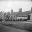
Fountainbridge. General view of street from East (demolished c.1934).
Collection of photographs by George Chrystal and Francis Maxwell Chrystal, photographers, Edinburgh,
1900
© Courtesy of HES (Francis M Chrystal Collection)

DP 193049
General oblique aerial view of the Fountainbridge and Merchiston areas of Edinburgh, looking NW.
RCAHMS Aerial Photography Digital
11/7/2014
© Crown Copyright: HES

DP 193067
General oblique aerial view of the Union Canal and the Fountainbridge and Merchiston areas of Edinburgh, looking NW.
RCAHMS Aerial Photography Digital
11/7/2014
© Crown Copyright: HES

DP 193072
Oblique aerial view of Fountainbridge and Lochrin Basin, looking E.
RCAHMS Aerial Photography Digital
11/7/2014
© Crown Copyright: HES

DP 195092
General view of 65-87 Fountainbridge, Edinburgh, taken from the north-east.
Records of the Royal Commission on the Ancient and Historical Monuments of Scotland (RCAHMS), Edinbu
13/8/2014
© Crown Copyright: HES

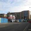
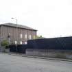
DP 195107
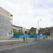
General view of north side of Fountainbridge, Edinburgh, taken from the south-west
Records of the Royal Commission on the Ancient and Historical Monuments of Scotland (RCAHMS), Edinbu
13/8/2014
© Crown Copyright: HES

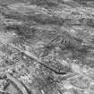
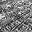
SC 1438288
Fountainbridge area Edinburgh, Midlothian, Scotland. Oblique aerial photograph taken facing South/West.
Aero Pictorial
11/8/1954
© Courtesy of HES (Aero Pictorial Collection)

SC 1438290
Fountainbridge area Edinburgh, Midlothian, Scotland. Oblique aerial photograph taken facing North/East.
Aero Pictorial
11/8/1954
© Courtesy of HES (Aero Pictorial Collection)

SC 1677127
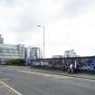
Oblique aerial view of Edinburgh centred on the Scottish Widows office building, Morrison Street, taken from the SW.
RCAHMS Aerial Photography
28/4/1999
© Crown Copyright: HES

SC 1677272
Oblique aerial view of Edinburgh centred on Fountainbridge, taken from the NW.
RCAHMS Aerial Photography
1991
© Crown Copyright: HES

SC 1677418
Oblique aerial view centred on the brewery with the canal, canal basin and canal bridge adjacent, taken from the SSW.
RCAHMS Aerial Photography
14/5/2003
© Crown Copyright: HES

SC 1677419
Oblique aerial view centred on the brewery with the canal, canal basin and canal bridge adjacent, taken from the SSE.
RCAHMS Aerial Photography
14/5/2003
© Crown Copyright: HES

SC 1677434
Oblique aerial view centred on the brewery with the leisure centre and cinema, canal, canal basin and canal bridge adjacent, taken from the E.
RCAHMS Aerial Photography
14/5/2003
© Crown Copyright: HES

SC 1679760
Oblique aerial view of Edinburgh centred on Fountainbridge, taken from the WNW.
RCAHMS Aerial Photography
1983
© Crown Copyright: HES

SC 1875803
Oblique aerial view showing the former Fountain Brewery with the leisure centre and cinema, canal, canal basin and canal bridge adjacent, Edinburgh
RCAHMS Aerial Photography
14/5/2003
© Crown Copyright: HES

SC 409266
Fountainbridge. General view of street at NT2461 7292 from West (buildings demolished c.1934).
Collection of photographs by George Chrystal and Francis Maxwell Chrystal, photographers, Edinburgh,
c. 1900
© Courtesy of HES (Francis M Chrystal Collection)

SC 828967
Oblique aerial view of Edinburgh centred on the Scottish Widows office building, Morrison Street, taken from the SW.
RCAHMS Aerial Photography
28/4/1999
© Crown Copyright: HES

SC 1042524
Oblique aerial view of Edinburgh centred on Fountainbridge, taken from the WNW.
RCAHMS Aerial Photography
1983
© Crown Copyright: HES

DP 089102
Card folder containing photographs of Fountainbridge and High Riggs. Front cover has pencil notes describing the photographs inside. Edinburgh Photographic Society Survey of Edinburgh District, Ward XIV George Square.
Records of Edinburgh Photographic Society, Edinburgh, Scotland
c. 1878
© Courtesy of HES (Edinburgh Photographic Society Collection)

DP 193054
General oblique aerial view of the Union Canal and the Fountainbridge and Viewforth areas of Edinburgh, looking SSE.
RCAHMS Aerial Photography Digital
11/7/2014
© Crown Copyright: HES

DP 193058
General oblique aerial view of the Union Canal and the Fountainbridge and Merchiston areas of Edinburgh, looking NE.
RCAHMS Aerial Photography Digital
11/7/2014
© Crown Copyright: HES

DP 193077
General oblique aerial view of Fountainbridge, Union Canal, Lochrin Basin and Edinburgh Quay, looking NNE.
RCAHMS Aerial Photography Digital
11/7/2014
© Crown Copyright: HES

DP 195093
General view of 65-87 Fountainbridge, Edinburgh, taken from the north-east.
Records of the Royal Commission on the Ancient and Historical Monuments of Scotland (RCAHMS), Edinbu
13/8/2014
© Crown Copyright: HES

DP 260097
View of Hampton by Hilton, 166 Fountainbridge, Edinburgh, from south-east
Records of the Royal Commission on the Ancient and Historical Monuments of Scotland (RCAHMS), Edinbu
30/8/2017
© Crown Copyright: HES

DP 260100
General view of Hampton by Hilton, 166 Fountainbridge, and McEwan Square, Edinburgh, from south-west
Records of the Royal Commission on the Ancient and Historical Monuments of Scotland (RCAHMS), Edinbu
30/8/2017
© Crown Copyright: HES

SC 1677433
Oblique aerial view centred on the brewery with the leisure centre and cinema, canal, canal basin and canal bridge adjacent, taken from the SE.
RCAHMS Aerial Photography
14/5/2003
© Crown Copyright: HES

DP 193050
General oblique aerial view of the Fountainbridge and Merchiston areas of Edinburgh, looking NW.
RCAHMS Aerial Photography Digital
11/7/2014
© Crown Copyright: HES

DP 193051
General oblique aerial view of the Fountainbridge and Merchiston areas of Edinburgh, looking WNW.
RCAHMS Aerial Photography Digital
11/7/2014
© Crown Copyright: HES

DP 193055
Oblique aerial view of Fountainbridge, Edinburgh, looking SSE.
RCAHMS Aerial Photography Digital
11/7/2014
© Crown Copyright: HES

DP 193060
General oblique aerial view of the Union Canal and the Fountainbridge and Merchiston areas of Edinburgh, looking SW.
RCAHMS Aerial Photography Digital
11/7/2014
© Crown Copyright: HES

DP 193065
Oblique aerial view of the Union Canal and Fountainbridge, looking NNE.
RCAHMS Aerial Photography Digital
11/7/2014
© Crown Copyright: HES

DP 193074
General oblique aerial view of Fountainbridge, Union Canal, Lochrin Basin and Edinburgh Quay, looking NE.
RCAHMS Aerial Photography Digital
11/7/2014
© Crown Copyright: HES

DP 195094
General view of north side of Fountainbridge, Edinburgh, taken from the south-east.
Records of the Royal Commission on the Ancient and Historical Monuments of Scotland (RCAHMS), Edinbu
13/8/2014
© Crown Copyright: HES

DP 195097
General view of 92-98 Fountainbridge, Edinburgh, taken from the south-east.
Records of the Royal Commission on the Ancient and Historical Monuments of Scotland (RCAHMS), Edinbu
13/8/2014
© Crown Copyright: HES

DP 195106
General view of North British Rubber Works, Gilmore Park, Fountainbridge, Edinburgh, taken from the north-west.
Records of the Royal Commission on the Ancient and Historical Monuments of Scotland (RCAHMS), Edinbu
13/8/2014
© Crown Copyright: HES

DP 260096
View of Hampton by Hilton, 166 Fountainbridge, Edinburgh, from south-west
Records of the Royal Commission on the Ancient and Historical Monuments of Scotland (RCAHMS), Edinbu
30/8/2017
© Crown Copyright: HES

SC 1676929
Oblique aerial view of Edinburgh centred on Bruntsfield.
RCAHMS Aerial Photography
1991
© Crown Copyright: HES

SC 1677089
Oblique aerial view of Edinburgh centred on the Scottish Widows building, taken from the SE.
RCAHMS Aerial Photography
28/4/1999
© Crown Copyright: HES

SC 1677243
Oblique aerial view of Edinburgh centred on Fountainbridge, taken from the NW.
RCAHMS Aerial Photography
1989
© Crown Copyright: HES

SC 1677270
Oblique aerial view of Edinburgh centred on Fountainbridge, taken from the SE.
RCAHMS Aerial Photography
1991
© Crown Copyright: HES


First 100 images shown. See the Collections panel (below) for a link to all digital images.
- Council Edinburgh, City Of
- Parish Edinburgh (Edinburgh, City Of)
- Former Region Lothian
- Former District City Of Edinburgh
- Former County Midlothian
Depicted on the coloured 1st edition of the OS 1:1056 scale map Edinburgh and its Environs, 1854, sheet 38
Project
Analysis of the Fountainbridge area of Edinburgh as part of a collaboration between the HES Urban Survey and Industrial Survey Programmes. This involved looking at historical development, topography and present character of the area, generating GIS-based maps of 3 Areas of Townscape Character accompanied by a comprehensive report.
Information from HES (LK), 1st April 2016

