Scheduled Maintenance
Please be advised that this website will undergo scheduled maintenance on the following dates: •
Tuesday 3rd December 11:00-15:00
During these times, some services may be temporarily unavailable. We apologise for any inconvenience this may cause.
Loch Achilty
Crannog (Period Unassigned)
Site Name Loch Achilty
Classification Crannog (Period Unassigned)
Canmore ID 12472
Site Number NH45NW 3
NGR NH 4304 5637
Datum OSGB36 - NGR
Permalink http://canmore.org.uk/site/12472
- Council Highland
- Parish Contin
- Former Region Highland
- Former District Ross And Cromarty
- Former County Ross And Cromarty
NH45NW 3 4304 5637.
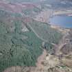
There is a tree-covered, artificial island about 80 yards from the south shore of Loch Achilty. It measures 54' - 60' by 34' - 42' and stands about 2' above normal water level. It is built of evenly coursed stones, and has a regular batter, the foundations measuring 79' by 59'. Timber projects from the NW, SW and east sides.
O Blundell 1913; D MacDonald, A Polson and D Brown 1931
NSA mentions buildings on a supposedly artificial island on Loch Achilty. These are said to be associated with 'MacLea Mor', who remains undated.
C Downie 1845
Name Book ascribes the artificiality and the MacLea association to Eilean Mhielidh (MacLea's Island) at NH 4348 5702 on the north side of the loch, stating at the same time that this island has every appearance of being natural. It makes no mention of the crannog on the south side.
Name Book 1876
It seems probable that the crannog on the south side is the true 'MacLea's Island' and should bear the remains of buildings.
At NH 43045637 there is a small artificial island composed of stones and largely submerged. The portion above water now measures 10.6 m E-W by 6.0 transversely, the submerged portion approx. 21.0 m E-W by 14.5 m. It supports a few trees.
There is now no trace of timber supports, a causeway, or buildings on the island; there is a possible harbour in the north.
Eilean Mhielidh, a pear shaped tree-covered island at NH 4348 5702, measuring 58.0m E to W by 23.5m transversely is undoubtedly natural and no trace of buildings could be found on it. Whether or not the crannog at NH 4304 5634 is associated with MacLea Mor, or whether Eileen Mhielidh is correctly associated with him, was not ascertained.
Visited by OS (R D) 12 July 1965
No Change. (The water level of the loch was high and no boat was available at the time of the investigation.)
Visited by OS (R F) 18 November 1970


