|
All Other |
MS 731/17 |
Records of the Royal Commission on the Ancient and Historical Monuments of Scotland (RCAHMS), Edinbu |
Afforestable Land Survey field database (Rogart survey, 1995). Held as attribute table in GIS and in Oracle Field/AP table. Please see DX001425 |
1995 |
Item Level |
|
|
Photographs and Off-line Digital Images |
C 55850 CN |
Records of the Royal Commission on the Ancient and Historical Monuments of Scotland (RCAHMS), Edinbu |
General view to SE from Reidchalmai farm, towards Remusaig crofts and Strath Fleet |
1996 |
Item Level |
|
|
Photographs and Off-line Digital Images |
C 46031 |
RCAHMS Aerial Photography |
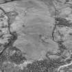
Little Rogart, oblique aerial view, taken from the NE, showing an area defined as an archaeological landscape. |
13/6/1995 |
Item Level |
|
|
Photographs and Off-line Digital Images |
C 46032 |
RCAHMS Aerial Photography |
Little Rogart, oblique aerial view, taken from the NE, showing an area defined as an archaeological landscape. |
13/6/1995 |
Item Level |
|
|
Photographs and Off-line Digital Images |
C 46034 |
RCAHMS Aerial Photography |
Little Rogart, oblique aerial view, taken from the SE, showing an area defined as an archaeological landscape. |
13/6/1995 |
Item Level |
|
|
Photographs and Off-line Digital Images |
C 46035 |
RCAHMS Aerial Photography |
Little Rogart, oblique aerial view, taken from the SE, showing an area defined as an archaeological landscape. |
13/6/1995 |
Item Level |
|
|
Photographs and Off-line Digital Images |
C 46036 |
RCAHMS Aerial Photography |
Little Rogart, oblique aerial view, taken from the SE, showing an area defined as an archaeological landscape. |
13/6/1995 |
Item Level |
|
|
Photographs and Off-line Digital Images |
C 46296 |
RCAHMS Aerial Photography |
Little Rogart, oblique aerial view, taken from the S, showing an area defined as an archaeological landscape. |
23/6/1995 |
Item Level |
|
|
Photographs and Off-line Digital Images |
C 46297 |
RCAHMS Aerial Photography |
Little Rogart, oblique aerial view, taken from the S, showing an area defined as an archaeological landscape. |
23/6/1995 |
Item Level |
|
|
Photographs and Off-line Digital Images |
C 46298 |
RCAHMS Aerial Photography |
Little Rogart, oblique aerial view, taken from the NE, showing an area defined as an archaeological landscape. |
23/6/1995 |
Item Level |
|
|
Photographs and Off-line Digital Images |
C 46299 |
RCAHMS Aerial Photography |
Little Rogart, oblique aerial view, taken from the N, showing an area defined as an archaeological landscape. |
23/6/1995 |
Item Level |
|
|
Photographs and Off-line Digital Images |
C 46300 |
RCAHMS Aerial Photography |
Little Rogart, oblique aerial view, taken from the NW, showing an area defined as an archaeological landscape. |
23/6/1995 |
Item Level |
|
|
Photographs and Off-line Digital Images |
C 46301 |
RCAHMS Aerial Photography |
Little Rogart, oblique aerial view, taken from the NW, showing an area defined as an archaeological landscape. |
23/6/1995 |
Item Level |
|
|
Photographs and Off-line Digital Images |
C 46302 |
RCAHMS Aerial Photography |
Little Rogart, oblique aerial view, taken from the NW, showing an area defined as an archaeological landscape. |
23/6/1995 |
Item Level |
|
|
Photographs and Off-line Digital Images |
C 46303 |
RCAHMS Aerial Photography |
Little Rogart, oblique aerial view, taken from the NW, showing an area defined as an archaeological landscape. |
23/6/1995 |
Item Level |
|
|
Photographs and Off-line Digital Images |
C 46304 |
RCAHMS Aerial Photography |
Little Rogart, oblique aerial view, taken from the WNW, showing an area defined as an archaeological landscape. |
23/6/1995 |
Item Level |
|
|
Photographs and Off-line Digital Images |
C 46305 |
RCAHMS Aerial Photography |
Little Rogart, oblique aerial view, taken from the WSW, showing an area defined as an archaeological landscape. |
23/6/1995 |
Item Level |
|
|
Photographs and Off-line Digital Images |
C 46306 |
RCAHMS Aerial Photography |
Little Rogart, oblique aerial view, taken from the SW, showing an area defined as an archaeological landscape. |
23/6/1995 |
Item Level |
|
|
Photographs and Off-line Digital Images |
C 41993 CN |
RCAHMS Aerial Photography |
Little Rogart, oblique aerial view, taken from the E, showing an area defined as an archaeological landscape. |
23/6/1995 |
Item Level |
|
|
Photographs and Off-line Digital Images |
C 41996 CN |
RCAHMS Aerial Photography |
Little Rogart, oblique aerial view, taken from the NNW, showing an area defined as an archaeological landscape. |
23/6/1995 |
Item Level |
|
|
Photographs and Off-line Digital Images |
C 41997 CN |
RCAHMS Aerial Photography |
Little Rogart, oblique aerial view, taken from the NW, showing an area defined as an archaeological landscape. |
23/6/1995 |
Item Level |
|
|
Photographs and Off-line Digital Images |
C 41998 CN |
RCAHMS Aerial Photography |
Little Rogart, oblique aerial view, taken from the W, showing an area defined as an archaeological landscape. |
23/6/1995 |
Item Level |
|
|
Photographs and Off-line Digital Images |
C 41999 CN |
RCAHMS Aerial Photography |
Little Rogart, oblique aerial view, taken from the W, showing an area defined as an archaeological landscape. |
23/6/1995 |
Item Level |
|
 |
On-line Digital Images |
SC 503654 |
Records of the Royal Commission on the Ancient and Historical Monuments of Scotland (RCAHMS), Edinbu |
Little Rogart, oblique aerial view, taken from the SE, showing an area defined as an archaeological landscape. |
|
Item Level |
|


