
Culburnie


Cup Marked Stone (Neolithic) - (Bronze Age), Ring Cairn (Neolithic) - (Bronze Age), Stone Circle (Neolithic) - (Bronze Age)
Site Name Culburnie
Classification Cup Marked Stone (Neolithic) - (Bronze Age), Ring Cairn (Neolithic) - (Bronze Age), Stone Circle (Neolithic) - (Bronze Age)
Alternative Name(s) Stone Circle
Canmore ID 12397
Site Number NH44SE 9
NGR NH 49182 41807
Datum OSGB36 - NGR
Permalink http://canmore.org.uk/site/12397


- Council Highland
- Parish Kiltarlity And Convinth
- Former Region Highland
- Former District Inverness
- Former County Inverness-shire
NH44SE 9 4916 4180.
(NH 4916 4180) Stone Circle (O'E.)
OS 6"map, Inverness-shire, 2nd ed., (1907)
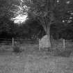
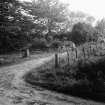
Culburnie: a ring-cairn in a group of trees beside the public road. The approach road to a nearby croft passes across the NW side, and the SW side is included in the croft garden.
The cairn composed of rounded boulders, has diameters of 42-44 ft. and a height of 5 ft. The kerb is virtually complete and is composed of large irregular boulders increasing in height from 1-2 ft on the N., to the SW. where there are impressive blocks 3 ft. 6in. - 4 ft. high. A modern wall has been built above the kerb on the SW side.
The interior space has diameters of 16-17 ft. and the walling is composed of boulders from 1 - 2 ft 9 ins in height. A hole 3 ft. square and 2 ft. deep has recently been dug in the centre.
There is a ring of eight monoliths, 10 - 14ft. outside the kerb, with an overall diameter of 70 ft. It is complete except for a gap on the NE where the ninth stone stood. The tallest monolith,on the SSW.,is 7 ft. high.
Cup-marks have been reported on three of the monoliths and three of the kerb stones, but they are now unconvincing except for the kerb stone on the SSW. which may have weathered cup-marks.
A S Henshall 1963
Ring-cairn as described above.
Surveyed at 1/2500.
Visited by OS (R L) 18 December 1964
Field Visit (17 August 1943)
This site was recorded as part of the RCAHMS Emergency Survey, undertaken by Angus Graham and Vere Gordon Childe during World War 2. The project archive has been catalogued during 2013-2014 and the material, which includes notebooks, manuscripts, typescripts, plans and photographs, is now available online.
Information from RCAHMS (GF Geddes) 12 November 2014.
Field Visit (March 1979)
Culburnie (INV 19) * NH 491 418 NH44SE 9 This fine Clava ring-cairn lies. within a circle of eight stones, a ninth having been removed from the NE. Both the walling around the interior, and the kerb are well preserved, and the cairn material still stands to a height of 1.5m. A kerb-stone on the SSW is cup-marked.
RCAHMS 1979, visited March 1979
(Henshall 1963-72, i, 370-1)
Watching Brief (2 June 2008 - 2 December 2009)
NH 49157 41797 Work was undertaken 15 December 2008 – August 2009 prior to the construction of a new building. Although this building will stand mainly on the footprint of the existing one, the site was considered sensitive, as the drive to the house passes between a Bronze Age burial cairn and an associated outer stone ring (Culburnie ring cairn – SAM 2425).
A desk-based assessment of the area revealed six notable features. Three are cairn composite features dated to the Neolithic and Bronze Ages (4000–700 BC): Bruaich ring cairn (NH44SE 3), Home Farm kerb cairn (NH44SE 16) and Culburnie ring cairn (NH44SE 9). The Old Statistical Account for the parish of Kiltarlity mentions the identification of six ‘druidical temples’, all ring and kerb cairns, and notes the associated placenames Bal na Carrachan (place of the circle) and Ard–druighnich (high place of the druids).
Two trenches were excavated, revealing a primary stratum made up of a mid-grey brown silty loam, gravel, stone and boulder mix. This was interpreted as redeposited fill associated with the construction and subsequent alterations to the original croft house. Significant subsoil disturbance, indicating previous intrusions, was confirmed in Trench 2 by the discovery of, at 0.05m, a clay drain pipe, running NW–SE away from the house. Both trenches came down onto natural sand, with occasional cobble and small boulder inclusions, overlaying bedrock. A single grinding stone was found but no other archaeological remains or features were identified.
Archive: RCAHMS. Report: HHER and Library Service (intended)
Funder: Alasdair and Lucie Rothe
Cait McCullagh – Highland Archaeology Services Ltd
OASIS ID: highland4-87338
Desk Based Assessment (2 June 2008 - 15 December 2009)
An archaeological watching brief was carried out to record the nature and extent of any archaeology revealed during renovation and extension of a house at 19 Culburnie, Kiltarlity. The programme included a Desk Based Assessment, initial photography of the building, safeguarding a scheduled ring cairn adjoining the drive , and a watching brief on groundworks. The excavation of two trenches was observed and recorded. In one, a re-deposited grinding / mortar stone, of uncertain date, was recovered from the remnant footing boulders,which had formed a part of the crofthouse shown as roofed on the 1st Edition Ordnance Survey 6 inch Map.
Information from OASIS ID: highland4-87338 (J Wood) 2009
Standing Building Recording (2 June 2008 - 15 December 2009)
An archaeological watching brief was carried out to record the nature and extent of any archaeology revealed during renovation and extension of a house at 19 Culburnie, Kiltarlity.
The programme included a Desk Based Assessment, initial photography of the building, safeguarding a scheduled ring cairn adjoining the drive , and a watching brief on groundworks.
The excavation of two trenches was observed and recorded. In one, a re-deposited grinding / mortar stone, of uncertain date, was recovered from the remnant footing boulders,which had formed a part of the crofthouse shown as roofed on the 1st Edition Ordnance Survey 6 inch Map.
Information from OASIS ID: highland4-87338 (J Wood) 2009
Note (23 January 2020)
Date Fieldwork Started: 23/01/2020
Compiled by: NOSAS
Location Notes: The panel is a large orthostat to the SE of the ring cairn at Culburnie, close to the boundary fence. It is on level ground, part of a low flattish ridge which slopes gently to the NE towards the river Beauly.
Panel Notes: The panel is a pointed triangular piece of schist, set upright, 1.6m high x 1.3m broad x 0.6m thick, and flat in section. It has two probable cupmarks low down on the outer face. The other orthostats and kerbstones associated with the cairn were also examined but no cupmarks were found.

