
Pricing Change
New pricing for orders of material from this site will come into place shortly. Charges for supply of digital images, digitisation on demand, prints and licensing will be altered.
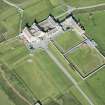
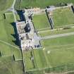
Skaill House


Burial Ground (Period Unassigned), Cist (Period Unassigned)
Site Name Skaill House
Classification Burial Ground (Period Unassigned), Cist (Period Unassigned)
Canmore ID 123653
Site Number HY21NW 40
NGR HY 2346 1860
Datum OSGB36 - NGR
Permalink http://canmore.org.uk/site/123653


- Council Orkney Islands
- Parish Sandwick
- Former Region Orkney Islands Area
- Former District Orkney
- Former County Orkney
HY21NW 40 2346 1860
HY 2346 1860 A medieval or Early Christian cemetery was discovered by Dr Raymond Lamb during drainage works at Skaill House. Six uncisted skeletons (one with its head within a stone box) were salvaged from a pipe trench, and the side of a cist containing human remains noted.
Glasgow University Archaeological Research Division (GUARD) undertook a five day excavation in two small areas. In Area A, beneath 1.3m of windblown sand, was a well laid-out cemetery aligned E-W, consisting of 12 upright stone grave markers, two flat slabs and two graves with several flat cover slabs. Two graves were partially excavated in order to determine the nature of the cemetery and to retrieve bone samples for radiocarbon dating.
In Area B, beneath 0.3m of made-up ground, were a further five uncisted burials aligned E-W. Both adults and children were represented. Further samples were taken for radiocarbon dating. The side of the cist noted by Dr Lamb was located, but as the drainage pipe had already been laid, it was not available for excavation. Three of the burials in Areas A and B had their skulls enclosed by head-boxes. No grave goods were found in the cemetery.
Three sections of walling were seen just beneath the surface to a depth of 0.71m in Area B. This walling post-dated the cemetery and was interpreted as the foundations for outhouses belonging to Skaill House which was constructed in the 17th century.
Sponsor: Historic Scotland
H F James 1997

