
Clachmhor, Culnakirk


Cup Marked Stone (Neolithic) - (Bronze Age), Stone Circle (Neolithic) - (Bronze Age)
Site Name Clachmhor, Culnakirk
Classification Cup Marked Stone (Neolithic) - (Bronze Age), Stone Circle (Neolithic) - (Bronze Age)
Canmore ID 12339
Site Number NH43SE 2
NGR NH 49915 31097
Datum OSGB36 - NGR
Permalink http://canmore.org.uk/site/12339


- Council Highland
- Parish Urquhart And Glenmoriston
- Former Region Highland
- Former District Inverness
- Former County Inverness-shire
NH43SE 2 49921 31099
Clachmhor [NAT]
Cup marked Stone [NR]
OS 1:25,000 map [undated].
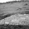
NH 4992 3109: 'Clachmhor' lies close to the east side of the farm of Culnakirk. It is a large flat block of grey gneiss about 16' long, 9' broad and 1' thick, lying N. and S. The southern half of the stone bears 113 cup- marks up to 4 1/4" diameter and 1 1/8" in depth, many united (usually in pairs) by grooves.
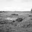
There are distinct indications that this stone was once surrounded by a circle of boulders or standing stones. Several of these still remain, 2 or 3 feet in width, 15 to 17 feet apart, on the north and east sides, and from 35 to 40 feet from 'Clachmaor'. On the south- west side, the circle has been obliterated by a rough cart track. which passes over its site.
W Jolly 1882.
This stone at NH 4992 3109 is as described by Jolly, but no trace of any standing stones could be found.
Surveyed at 1/2500.
Visited by OS (R D) 3 December 1964.
Scheduled as 'Clachmhor, cup-marked stone... a large flat triangular block of grey gneiss about 5m long, 3m broad and 0.3m thick, oriented N to S, containing a large number of cup marks. It is situated on relatively flat ground above the upper break of a slope on a wide, steep valley, adjacent to a stream.'
Information from Historic Scotland, scheduling document dated 18 October 2006.
Field Visit (23 September 1997)
NH43SE 2 49921 31099
Clachmhor is a large triangular erratic block, situated in a pasture field to the NE of Culnakirk farmsteading. Its upper surface bears at least ninety weathered plain cupmarks, some conjoined in pairs, and measuring up to 90mm by 30mm. A ring of upcast material around the stone probably indicates a relatively recent attempt to move it.
Visited by RCAHMS (JBS) 23 September 1997.
Field Visit (5 August 2008 - 28 August 2008)
NH 51144 38388 to NH 49873 30900 Work was undertaken, 5–28 August 2008, to assess the potential impact of a new overhead electricity line between Ardendrain and Culnakirk. 34 sites were identified. The following sites of note were recorded:
Clachmor cup-marked stone (NH43SE 2) SAM (No. 552054), recorded in 1882 as consisting of a large flat
triangular block of grey gneiss 5m long, 3m broad and 0.3m thick, oriented N/ S, containing a 113 cup marks. The stone was found to meet the dimensions recorded in 1882. However, only 37 cup marks were noted.
Archive: HAS
Cait McCullagh – Highland Archaeology Services Ltd
Watching Brief (20 April 2009 - 17 June 2009)
Kiltarlity – Drumnadrochit (All Dearg – Culnakirk)
Overhead Line Refurbishment
Watching brief
Cait McCullagh – Highland Archaeology Services Ltd
NH 5114 3838 to NH 4987 3090 A watching brief was carried out on the renewal of the overhead electric line, 20 April–17 June 2009. The excavation of 78 trenches and the removal of 31 poles was observed and photographically recorded.
The subsoil in the trenches from the start of the monitored area through to NH 50352 35376 revealed an underlying stratigraphy of glacial till (sand with stone, cobble and boulder inclusions). Much of the remainder of the route traversed waterlogged bog or rough pasture. The subsoil in these areas comprised varying depths of well humified dark brown-black and/or mid-red brown partially humified peat, which on occasion came down onto blue–grey waterlogged clay. The large quantities of woody material in the upper peat layers of trenches from NH 50031 33435 – NH 50015 33280 may represent the remains of relict forests, or more recent forestry. There are many plough scrapes and hollows and a number of modern access paths cut into the ground in this area. All trenches and pole holes were devoid of archaeology.
The Creag Ard hut circles at NH 5000 3227 and NH 4987 3215 and the Clachmor cup-marked stone and associated ring ditch at NH 499 310 were marked out before works commenced. A possible hut circle was located 9m W of NH 4987 3213, obscured by heavy gorse, and could be part of the Creag Ard hut circle and cairn field complex. A denuded hut circle was identified at NH 50326 34941 during a walkover survey ahead of trenching. This feature, the Easter Cudrish hut circle, was found to be mostly as described on the HHER
and was also marked out.
Archive: RCAHMS. Report: HHER and Library Service (intended)
Funder: Scottish and Southern Energy
Note (13 August 2020)
Date Fieldwork Started: 13/08/2020
Compiled by: NOSAS
Location Notes: The site, which is a scheduled monument (SM 11435) lies about 25m W of the Culnakirk Burn in a field of improved pasture on the SSE facing slope overlooking the River Enrick, very near where it enters Loch Ness to the E. There is a polytunnel and house, Clachmhor, to the S and an occasionally used farm track to the W of the stone. There is a second cup marked panel beside the minor road 80m to the SW called the Culnakirk stone. The owner of the nearby house knew of the stones presence in the field. There are several prehistoric sites in the area, a Clava type cairn to the W, hut circles lie to the N and the multiperiod site of Garbeg is about 1km to the E.
Panel Notes: This is a large erratic boulder of gneiss, roughly triangular in shape, measuring 4.3 x 2.9m and rising up to 0.7m above the grass of the field. Around the stone there is a shallow circular ditch and bank, which was noted by Rev. Jolly in 1882 and interpreted by him as being part of a stone circle. This interpretation was not confirmed by later recorders. On the day of the visit the grass around the boulder was short and there were sheep in the field. Across the S of the stone there are over 84 cupmarks, including several curved and linear alignments, 5 ovals and 2 dumbbells .There are several fissures on the surface, a few quartz inclusions and an area of less smooth stone at the W end of the boulder.

