
Following the launch of trove.scot in February 2025 we are now planning the retiral of some of our webservices. Canmore will be switched off on 24th June 2025. Information about the closure can be found on the HES website: Retiral of HES web services | Historic Environment Scotland
Benbecula, Aird


Township (Period Unassigned)
Site Name Benbecula, Aird
Classification Township (Period Unassigned)
Canmore ID 123355
Site Number NF75SE 24
NGR NF 7630 5480
NGR Description centred on NF 763 548
Datum OSGB36 - NGR
Permalink http://canmore.org.uk/site/123355


- Council Western Isles
- Parish South Uist
- Former Region Western Isles Islands Area
- Former District Western Isles
- Former County Inverness-shire
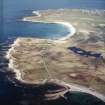
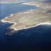
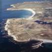
NF75SE 24 centred on 7630 5480
A crofting township comprising twenty-nine roofed, four partially roofed and three unroofed buildings is depicted on the 1st edition of the OS 6-inch map (Inverness-shire, Hebrides, North & South Uist etc. 1880, sheet xliv). Sixteen roofed, three partially roofed and seven unroofed buildings are shown on the current edition of the OS 1:10000 map (1972).
Information from RCAHMS (SAH) 5 May 1997
Archaeological Evaluation (24 August 2009 - 28 August 2009)
NF 76355 54755 An evaluation was undertaken 24–28 August 2009 in advance of the construction of a house. The work was required due to the site’s proximity to a long cist burial (NF 76306 54780 – SMR 5040). Five trenches were excavated, covering 10% of the footprint of the proposed house. No archaeological deposits or features were identified in the trenches. Two concrete platforms to the E of the development area may relate to temporary army buildings reportedly put up on this site during WW2.
Archive: RCAHMS (intended). Report: CNES SMR and RCAHMS
Funder: Kenneth MacDonald
Kate MacDonald and Rebecca Rennell – Uist Archaeology

