
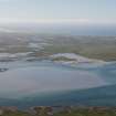
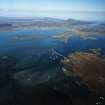
Benbecula, Gramsdale, General


School (Period Unassigned), Township (Period Unassigned)
Site Name Benbecula, Gramsdale, General
Classification School (Period Unassigned), Township (Period Unassigned)
Canmore ID 123269
Site Number NF85NW 18
NGR NF 816 555
NGR Description Centred NF 816 555
Datum OSGB36 - NGR
Permalink http://canmore.org.uk/site/123269


- Council Western Isles
- Parish South Uist
- Former Region Western Isles Islands Area
- Former District Western Isles
- Former County Inverness-shire
Note
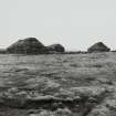
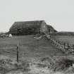
A crofting township comprising four roofed buildings, one of which is annotated as a School, and fourteen unroofed buildings is depicted on the 1st edition of the OS 6-inch map (Inverness-shire, Hebrides, North & South Uist etc. 1880, sheet xliv).
Thirteen roofed and four unroofed buildings are shown on the current edition of the OS 1:10000 map (1972).
Information from RCAHMS (SAH), 6 May 1997.

