Accessibility

Font Size

100% 150% 200%

Background Colour

Default Contrast
Close Reset

Forth Defences, Outer, Inchkeith, "l" Group (Later "h" Group), 9.2-inch Gun Emplacement

Coastal Battery (20th Century), Coastal Battery (Second World War), Coastal Battery (First World War)

Site Name Forth Defences, Outer, Inchkeith, "l" Group (Later "h" Group), 9.2-inch Gun Emplacement

Classification Coastal Battery (20th Century), Coastal Battery (Second World War), Coastal Battery (First World War)

Alternative Name(s) The Cawcans; North Battery

Canmore ID 122972

Site Number NT28SE 5.05

NGR NT 29277 82945

Datum OSGB36 - NGR

Permalink http://canmore.org.uk/site/122972

Ordnance Survey licence number AC0000807262. All rights reserved.
Canmore Disclaimer. © Bluesky International Limited 2025. Public Sector Viewing Terms

Toggle Aerial | View on large map

Digital Images

Oblique aerial view of Inchkeith Island centred on the defences, taken from the NNE.
Oblique aerial view of Inchkeith Island centred on the defences, taken from the NNE.Oblique aerial view centred on part of the northern defences, taken from the NE.Oblique aerial view centred on the northern defences, taken from the NW.Oblique aerial view centred on the central defences, taken from the ENE.General view of gun emplacement with later brick and concrete canopy from the SE.Detail of part of the gun pit with access bridge between front and rear sections.  Also visible is  part of a cable trench.General view from above of gun emplacement with later brick and concrete canopy, taken from the SSE.Oblique aerial view of Inchkeith Island centred on the defences, taken from the NE.Oblique aerial view of Inchkeith Island centred on the defences, taken from the NNW.Oblique aerial view of Inchkeith Island centred on the defences, taken from the W.Oblique aerial view centred on the central defences, taken from the SE.Oblique aerial view centred on the northern defences, taken from the NE.Oblique aerial view centred on the northern defences, taken from the N.Oblique aerial view centred on the northern defences, taken from the N.Oblique aerial view centred the central defences, taken from the SE.Oblique aerial view centred on the northern defences, taken from the WNW.General view of gun emplacement with the lighthouse in the background and some of the accommodation huts in the foreground, taken from the NNW.Detail of ventilator bricks in courtyard below the gun emplacement.Detail of entrances to accommodation and office rooms in courtyard below the gun emplacement from the NNWGeneral view from above of rock-cut courtyard below the gun emplacement from NE.Interior. Detail of 9.2-inch calibre shell hoist and winding gear.Oblique aerial view of Inchkeith Island centred on the defences, taken from the NE.Oblique aerial view of Inchkeith Island centred on the defences, taken from the NW.Oblique aerial view centred on the central and northern defences, taken from the SE.Oblique aerial view centred on the central defences, taken from the NE.Oblique aerial view centred on the northern defences, taken from the N.Oblique aerial view centred on the northern defences, taken from the NNW.Oblique aerial view centred on the northern defences, taken from the NW.Oblique aerial view centred on the northern defences, taken from the NW.Detail of courtyard and offices below the gun emplacement from NNE.Oblique aerial view of Inchkeith Island centred on the defences, taken from the NNE.Oblique aerial view centred on Inchkeith northern defences and New Lighthouse, taken from the NW.Oblique aerial view centred on the mid and S defences, taken from the NE.Oblique aerial view centred on the central defences, taken from the W.Detail of courtyard below the gun emplacement showing access steps to gun pit from SSW.Detail of office block in courtyard below the gun emplacement from SE.Interior, view of magazine area.Oblique aerial view centred on the central defences, taken from the E.Oblique aerial view centred on the northern and central defences, taken from the NE.View of rear of gun emplacement showing later brick and concrete canopy structure, from W.Detail of part of the gun pit showing metal rings for gun maintenance, taken from the ESE.Detail of part of the gun pit with access bridge between front and rear sections.  Also visible is part of a cable trench.General view from above of gun emplacement with later brick and concrete canopy, taken from the SSE.Oblique aerial view of Inchkeith Island centred on the defences, taken from the WNW.Oblique aerial view centred on the dam, taken from the SE.Oblique aerial view centred on Mid and S defences, taken from the E.Oblique aerial view centred on part of the northern defences, taken from the NW.Oblique aerial view centred on the northern defences, taken from the NW.Oblique aerial view centred on the northern defences, taken from the NW.Oblique aerial view centred on the northern defences, taken from the WNW.Oblique aerial view centred on the central defences, taken from the E.Oblique aerial view centred on the central defences, taken from the NW.Interior, view of magazine.Oblique aerial view of Inchkeith Island centred on the defences, taken from the NNW.Oblique aerial view centred on Inchkeith central defences and New Lighthouse, taken from the NNW.Oblique aerial view centred on the central defences and part of the northern defences, taken from the NW.General view of gun emplacement and low level courtyard from SSE.Oblique aerial view of Inchkeith Island centred on the defences, taken from the N.Oblique aerial view centred on the northern defences, taken from the NW.Oblique aerial view centred on the northern defences, taken from the NW.General view of gun emplacement from SSE.View to ENE from gun emplacement.Interior, view of a magazine.Oblique aerial view of Inchkeith Island centred on the defences, taken from the WNW.Oblique aerial view of Inchkeith Island centred on the defences, taken from the NE.

Administrative Areas

  • Council Fife
  • Parish Kinghorn
  • Former Region Fife
  • Former District Kirkcaldy
  • Former County Fife

World War One Audit of Surviving Remains (7 November 2013)

SUMMARY RECORD

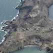
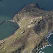
"Three 9.2-inch guns formed the main armament of Inchkeith. This calibre of gun was intended to tackle the largest enemy ships that might attack the British coast. The guns were mounted in separate emplacements set along the high central ridge of the island: that originally known as “L” Group was the northernmost, to the north of the lighthouse. The emplacement was originally built in 1893-5 to hold a 4.7-inch Quick Firing gun. The 4.7-inch gun was removed in June 1903 and replaced by the 9.2-inch gun in 1904. The three 9.2-inch guns formed the only heavy armament of the island on the outbreak of the First World War, prior to the reinstatement of the 6-inch guns. [WO 192/251]

By February 1918 what had hitherto been called “L” Group was re-named “H” Group [WO 192/251]. By 1938 the gun’s name had changed again, to “North 9.2” gun”.

The emplacement was originally open but a canopy of brick and concrete with steel supporting beams was added prior to or in the early stages of the Second World War, to provide protection from air attack.

Archaeology Notes

NT28SE 5.05 29277 82945

This battery is annotated on a plan of the island (PRO 192/251), as containing a 9.2" calibre gun and is situated immediately N of the lighthouse (NT28SE 6).

Information from RCAHMS (DE) November 1997.

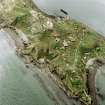
The third large 9.2-inch gun emplacement of three on the Island, on the central ridge, but on a small plateau, N of the lighthouse (NT28SE 6.00).

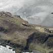
The single emplacement for a 9.2-inch gun consists of a concrete gun pit, brick and concrete canopy all set over extensive underground magazines, offices and rooms.

The below ground installation is entered through a small courtyard S of the emplacement and via a rock cut trench, which is cut from W of the site. A suit of rooms on all sides of the courtyard, some having been cut into and from the rock at the S end. The entrance to the magazines on the N side.The remains of a metal stair leads to the gun emplacement immediately to the N..

Below ground is a brick lined corridor leading to the magazines with a shell hoist for the large calibre ammunition positioned about half way along.

Within the circular gun pit are several ready-use ammunition lockers and a moveable 'bridge' provides access to the rear of the gun emplacement. A large cable trench runs across the floor of the gun pit and a series of large metal rings are set around the wall of the gun pit, installed to assist in the servicing of the guns allowing them to be jack hoisted into position using the rings to provide stablising points.

The emplacement when built was likely to have been an open mounting with no canopy and it is likely that the brick and concrete canopy with steel supporting beams was added either immediately before World War II or in late 1939-early 1940. The gun emplacement is annotated as 'L Group' on the War Office plan of the Island (copy held in RCAHMS under MS 879/83).

Visited by RCAHMS (DE, AL, JM), 25 February, 3 and 5th March 2009

Activities

Project (March 2013 - September 2013)

A project to characterise the quantity and quality of the Scottish resource of known surviving remains of the First World War. Carried out in partnership between Historic Scotland and RCAHMS.

References

MyCanmore Image Contributions


Contribute an Image

MyCanmore Text Contributions