
Following the launch of trove.scot in February 2025 we are now planning the retiral of some of our webservices. Canmore will be switched off on 24th June 2025. Information about the closure can be found on the HES website: Retiral of HES web services | Historic Environment Scotland
Bonnyside West


Signal Platform (Roman)
Site Name Bonnyside West
Classification Signal Platform (Roman)
Alternative Name(s) Antonine Wall; Bonnyside Expansions
Canmore ID 122823
Site Number NS87NW 4.01
NGR NS 8346 7980
Datum OSGB36 - NGR
Permalink http://canmore.org.uk/site/122823


- Council Falkirk
- Parish Falkirk
- Former Region Central
- Former District Falkirk
- Former County Stirlingshire
NS87NW 4.01 8346 7980
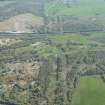
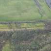
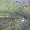
NS 8379 7980 and NS 8346 7980. There are two 'expansions' projecting from the S face of the Antonine Wall rampart at Bonnyside. When visited in 1957, they were roughly semi-circular on plan, measuring about 10.0m E-W at the rampart face by 7.0m N-S, with a maximum height of 1.2m.
Considerations of siting and the discovery of burnt deposits of wood, turfwork and Roman pottery in the immediate vicinity of the eastern expansion indicate that they were beacon stances, communicating with the area N of the Wall.
Visited by OS (JLD) 24 January 1957.
K A Steer 1959; RCAHMS 1963, visited 1957.
No change.
Visited by OS (MJF) 20 November 1980
Note (1978)
Bonnyside East, NS 837 798 NS87NW 4
Signalling Platform.
RCAHMS 1978
(Macdonald, 1934, 130, 350-3; Steer 1957; RCAHMS 1963, pp. 93-6, No.111)
Publication Account (2008)
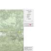
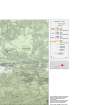
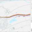
A 1:25000 scale map of the Antonine Wall was published by RCAHMS in 2008. The map shows the course of the Antonine Wall on a modern map base, including areas where the Wall is in public ownership or care and can be visited. The data had been collated as part of the project to prepare maps for the World Heritage Site nomination bid.

