
Falkirk, High Station Road, Falkirk High Station


Railway Station (19th Century) - (20th Century)
Site Name Falkirk, High Station Road, Falkirk High Station
Classification Railway Station (19th Century) - (20th Century)
Canmore ID 122764
Site Number NS87NE 48
NGR NS 88279 79104
Datum OSGB36 - NGR
Permalink http://canmore.org.uk/site/122764


- Council Falkirk
- Parish Falkirk
- Former Region Central
- Former District Falkirk
- Former County Stirlingshire
NS87NE 48.00 88279 79104
Station [NAT]
OS 1:10,000 map, 1981.
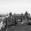
NS87NE 48.01 88350 79080 Railwaymen's Houses
NS87NE 48.02 88395 78968 Coal Yard
Not to be confused with Falkirk, Grahamston Station (NS 88752 80252), for which see NS88SE 98. For nearby Hallglen, Railway Tunnel (NS 8851 7891 to 8911 7841), see NS87NE 49.
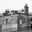
(Location cited as NS 883 791). Falkirk (High) Station, opened 1842 by the Edinburgh and Glasgow Rly. A two-platform through ststion on a curve. The main offices are on the up platform, in a 1-storey and attic ashlar building, incorporating a dwelling-house, with a platform awning added later, and subsequently modernised.
J R Hume 1976.
This intermediate station was opened (as Falkirk station) on 21 February 1842 by the Edinburgh and Glasgow Rly. and renamed Falkirk High station on 1 February 1903. It remains in regular use by passenger traffic.
R V J Butt 1995.

