
Char's Stone


Standing Stone (Prehistoric)
Site Name Char's Stone
Classification Standing Stone (Prehistoric)
Canmore ID 12257
Site Number NH33SE 7
NGR NH 39831 31043
Datum OSGB36 - NGR
Permalink http://canmore.org.uk/site/12257


- Council Highland
- Parish Kiltarlity And Convinth
- Former Region Highland
- Former District Inverness
- Former County Inverness-shire
NH33SE 7 39831 31043.
(NH 3984 3105) Char's Stone (NR)
OS 6"map, Inverness-shire, 2nd ed., (1904)
A standing stone traditionally marking the grave of Char, son of one of the kings of Denmark. It is approximately 3' high and 1 1/2' square
at the base.
Name Book 1871
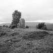
A stone 1.1m high by 0.7m broad by 0.4m thick. It stands in the centre of a circular stony mound about 6.0m in diameter and 0.4m high which in turn surmounts a knoll commanding a wide view of the Corrimony district. The mound may be original but could possibly be due to clearance piled round the base of the stone.
Visited by OS (J M) 10 June 1974
This stone has now split and fallen.
G Harden 1985
Field Visit (16 September 1943)
Standing Stone, ‘Char’s Stone’, Buntail, stands on the crest of a ridge N of the steading about 780’ above OD. It now projects above rather than standing on a grass-grown cairn apparently composed of small stones. Above this the stone rises 3’ 4”, and it measures 1’ 11” x 1’ 4” round the base.
Visited by RCAHMS (VGC) 16 September 1943.
Map ref: xxviii (Char’s Stone)
Field Visit (22 October 1997)
NH33SE 7 39831 31043.
No trace of this standing stone was located at the date of survey and its site lies within a mound of field clearance.
Visited by RCAHMS (PJD) 22 October 1997
Project (May 2001)
A project of archaeological survey and evaluation was undertaken for Team Aquarius, on behalf of NOSWA by Headland Archaeology in advance of a water mains pipeline along Glen Urquhart, Highland. The proposed route runs from Tomich (NH 314 277) north to Cannich (NH 334 318) and then east towards Drumnadrochit where it splits to the north (NH 502 332) and south (NH 498 283). The proposed route is largely along the roadside but four stretches are through farmland or forestry. The survey comprised an initial desk based assessment to examine all available documentary and map sources prior to commencement of fieldwork, a walkover survey of the entire route and a watching brief on six trial pits highlighted as being in archaeologically sensitive areas by Highland Council’s Planning and Development Department Archaeological Officer. A full specification for the archaeological work was prepared by Highland Council.
Headland Archaeology 2001

