
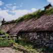
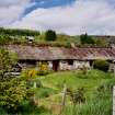
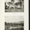
Camserney Farm


Cruck Framed Building(S) (Post Medieval), Farmstead (Period Unassigned), Lime Kiln (Period Unassigned), Township (Period Unassigned)
Site Name Camserney Farm
Classification Cruck Framed Building(S) (Post Medieval), Farmstead (Period Unassigned), Lime Kiln (Period Unassigned), Township (Period Unassigned)
Alternative Name(s) Camserne; Gamserney; Camserney Farm, Long House
Canmore ID 122466
Site Number NN84NW 41
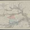
NGR NN 81651 49277
NGR Description centred on NN 81651 49277
Datum OSGB36 - NGR
Permalink http://canmore.org.uk/site/122466
Ordnance Survey licence number AC0000807262. All rights reserved.
Canmore Disclaimer.
© Bluesky International Limited 2025. Public Sector Viewing Terms
- Correction
- Favourite

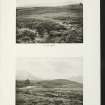
DP 140618
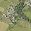
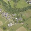
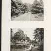
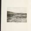
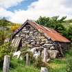
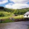
Oblique aerial view of Camserney Farm, taken from the ESE.
RCAHMS Aerial Photography Digital
2/8/2012
© Crown Copyright: HES

SC 2152287
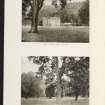
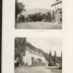
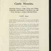
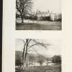
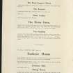
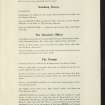
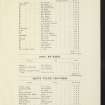
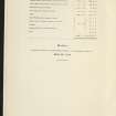
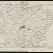
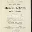
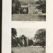
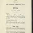
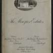
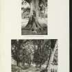
Estate Exchange. The Menzies Estate. nos. 1522 & 1523 Sale Brochure 1914. Title: 'The Menzies Estates'. Dalrawer Farm, Domnaheiche, Donafull farm, Donlellan with Burnside, Glassie Farm, Kinardochy Farm, Glengowlandie Farm, Camusericht Farm, Carse Farm, Corrievarkie Lodge, Croft Na Muick Farm, Craiganour Lodge, Shenvail Farm, Frenich Farm, Foss Home farm, Tirinie Farm
Collection of sale catalogues relating to Scottish estates
29/5/1914
© Courtesy of HES (Estates Exchange Collection)

SC 2152299
Estate Exchange. The Menzies Estate. nos. 1522 & 1523 Sale Brochure 1914. Title: 'The Menzies Estates'. Dalrawer Farm, Domnaheiche, Donafull farm, Donlellan with Burnside, Glassie Farm, Kinardochy Farm, Glengowlandie Farm, Camusericht Farm, Carse Farm, Corrievarkie Lodge, Croft Na Muick Farm, Craiganour Lodge, Shenvail Farm, Frenich Farm, Foss Home farm, Tirinie Farm
Collection of sale catalogues relating to Scottish estates
29/5/1914
© Courtesy of HES (Estates Exchange Collection)

SC 2152304
Estate Exchange. The Menzies Estate. nos. 1522 & 1523 Sale Brochure 1914. Title: 'The Menzies Estates'. Dalrawer Farm, Domnaheiche, Donafull farm, Donlellan with Burnside, Glassie Farm, Kinardochy Farm, Glengowlandie Farm, Camusericht Farm, Carse Farm, Corrievarkie Lodge, Croft Na Muick Farm, Craiganour Lodge, Shenvail Farm, Frenich Farm, Foss Home farm, Tirinie Farm
Collection of sale catalogues relating to Scottish estates
29/5/1914
© Courtesy of HES (Estates Exchange Collection)

SC 2152309
Estate Exchange. The Menzies Estate. nos. 1522 & 1523 Sale Brochure 1914. Title: 'The Menzies Estates'. Dalrawer Farm, Domnaheiche, Donafull farm, Donlellan with Burnside, Glassie Farm, Kinardochy Farm, Glengowlandie Farm, Camusericht Farm, Carse Farm, Corrievarkie Lodge, Croft Na Muick Farm, Craiganour Lodge, Shenvail Farm, Frenich Farm, Foss Home farm, Tirinie Farm
Collection of sale catalogues relating to Scottish estates
29/5/1914
© Courtesy of HES (Estates Exchange Collection)

SC 2152312
Estate Exchange. The Menzies Estate. nos. 1522 & 1523 Sale Brochure 1914. Title: 'The Menzies Estates'. Dalrawer Farm, Domnaheiche, Donafull farm, Donlellan with Burnside, Glassie Farm, Kinardochy Farm, Glengowlandie Farm, Camusericht Farm, Carse Farm, Corrievarkie Lodge, Croft Na Muick Farm, Craiganour Lodge, Shenvail Farm, Frenich Farm, Foss Home farm, Tirinie Farm
Collection of sale catalogues relating to Scottish estates
29/5/1914
© Courtesy of HES (Estates Exchange Collection)

SC 2152321
Estate Exchange. The Menzies Estate. nos. 1522 & 1523 Sale Brochure 1914. Title: 'The Menzies Estates'. Dalrawer Farm, Domnaheiche, Donafull farm, Donlellan with Burnside, Glassie Farm, Kinardochy Farm, Glengowlandie Farm, Camusericht Farm, Carse Farm, Corrievarkie Lodge, Croft Na Muick Farm, Craiganour Lodge, Shenvail Farm, Frenich Farm, Foss Home farm, Tirinie Farm
Collection of sale catalogues relating to Scottish estates
29/5/1914
© Courtesy of HES (Estates Exchange Collection)

SC 2152324
Estate Exchange. The Menzies Estate. nos. 1522 & 1523 Sale Brochure 1914. Title: 'The Menzies Estates'. Dalrawer Farm, Domnaheiche, Donafull farm, Donlellan with Burnside, Glassie Farm, Kinardochy Farm, Glengowlandie Farm, Camusericht Farm, Carse Farm, Corrievarkie Lodge, Croft Na Muick Farm, Craiganour Lodge, Shenvail Farm, Frenich Farm, Foss Home farm, Tirinie Farm
Collection of sale catalogues relating to Scottish estates
29/5/1914
© Courtesy of HES (Estates Exchange Collection)

SC 2152327
Estate Exchange. The Menzies Estate. nos. 1522 & 1523 Sale Brochure 1914. Title: 'The Menzies Estates'. Dalrawer Farm, Domnaheiche, Donafull farm, Donlellan with Burnside, Glassie Farm, Kinardochy Farm, Glengowlandie Farm, Camusericht Farm, Carse Farm, Corrievarkie Lodge, Croft Na Muick Farm, Craiganour Lodge, Shenvail Farm, Frenich Farm, Foss Home farm, Tirinie Farm
Collection of sale catalogues relating to Scottish estates
29/5/1914
© Courtesy of HES (Estates Exchange Collection)

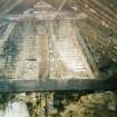
SC 1222392
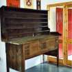
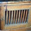
Camserney Farm, Long House: the dresser and plate rack from the long house, removed around 1956
Scotland's Rural Past
2005
© RCAHMS

DP 140616
Oblique aerial view of Camserney Farm, taken from the S.
RCAHMS Aerial Photography Digital
2/8/2012
© Crown Copyright: HES

DP 140617
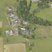
Oblique aerial view of Camserney Farm, taken from the SE.
RCAHMS Aerial Photography Digital
2/8/2012
© Crown Copyright: HES

SC 2152293
Estate Exchange. The Menzies Estate. nos. 1522 & 1523 Sale Brochure 1914. Title: 'The Menzies Estates'. Dalrawer Farm, Domnaheiche, Donafull farm, Donlellan with Burnside, Glassie Farm, Kinardochy Farm, Glengowlandie Farm, Camusericht Farm, Carse Farm, Corrievarkie Lodge, Croft Na Muick Farm, Craiganour Lodge, Shenvail Farm, Frenich Farm, Foss Home farm, Tirinie Farm
Collection of sale catalogues relating to Scottish estates
29/5/1914
© Courtesy of HES (Estates Exchange Collection)

SC 2152320
Estate Exchange. The Menzies Estate. nos. 1522 & 1523 Sale Brochure 1914. Title: 'The Menzies Estates'. Dalrawer Farm, Domnaheiche, Donafull farm, Donlellan with Burnside, Glassie Farm, Kinardochy Farm, Glengowlandie Farm, Camusericht Farm, Carse Farm, Corrievarkie Lodge, Croft Na Muick Farm, Craiganour Lodge, Shenvail Farm, Frenich Farm, Foss Home farm, Tirinie Farm
Collection of sale catalogues relating to Scottish estates
29/5/1914
© Courtesy of HES (Estates Exchange Collection)

SC 2152336
Estate Exchange. The Menzies Estate. nos. 1522 & 1523 Sale Brochure 1914. Title: 'The Menzies Estates'. Dalrawer Farm, Domnaheiche, Donafull farm, Donlellan with Burnside, Glassie Farm, Kinardochy Farm, Glengowlandie Farm, Camusericht Farm, Carse Farm, Corrievarkie Lodge, Croft Na Muick Farm, Craiganour Lodge, Shenvail Farm, Frenich Farm, Foss Home farm, Tirinie Farm
Collection of sale catalogues relating to Scottish estates
29/5/1914
© Courtesy of HES (Estates Exchange Collection)

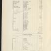
SC 2391016
Camserney Farm, NN84NW 41, Ordnance Survey index card, Recto
Records of the Ordnance Survey, Southampton, Hampshire, England
c. 1958
© Crown Copyright: HES (Ordnance Survey Archaeology Division)

SC 2391017
Camserney Farm, NN84NW 41, Ordnance Survey index card, Recto
Records of the Ordnance Survey, Southampton, Hampshire, England
c. 1958
© Crown Copyright: HES (Ordnance Survey Archaeology Division)


SC 1222389
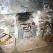
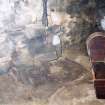
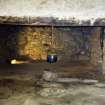
Camserney Farm, Long House, E end: hearth with flue, on eastern gable wall of existing structure
Scotland's Rural Past
2005
© RCAHMS

SC 1222393
Camserney Farm, Long House: detail of the door to the central compartment of the dresser which was removed from the house about 1956
Scotland's Rural Past
2005
© RCAHMS

SC 2152286
Estate Exchange. The Menzies Estate. nos. 1522 & 1523 Sale Brochure 1914. Title: 'The Menzies Estates'. Dalrawer Farm, Domnaheiche, Donafull farm, Donlellan with Burnside, Glassie Farm, Kinardochy Farm, Glengowlandie Farm, Camusericht Farm, Carse Farm, Corrievarkie Lodge, Croft Na Muick Farm, Craiganour Lodge, Shenvail Farm, Frenich Farm, Foss Home farm, Tirinie Farm
Collection of sale catalogues relating to Scottish estates
29/5/1914
© Courtesy of HES (Estates Exchange Collection)

SC 2152302
Estate Exchange. The Menzies Estate. nos. 1522 & 1523 Sale Brochure 1914. Title: 'The Menzies Estates'. Dalrawer Farm, Domnaheiche, Donafull farm, Donlellan with Burnside, Glassie Farm, Kinardochy Farm, Glengowlandie Farm, Camusericht Farm, Carse Farm, Corrievarkie Lodge, Croft Na Muick Farm, Craiganour Lodge, Shenvail Farm, Frenich Farm, Foss Home farm, Tirinie Farm
Collection of sale catalogues relating to Scottish estates
29/5/1914
© Courtesy of HES (Estates Exchange Collection)

SC 2152305
Estate Exchange. The Menzies Estate. nos. 1522 & 1523 Sale Brochure 1914. Title: 'The Menzies Estates'. Dalrawer Farm, Domnaheiche, Donafull farm, Donlellan with Burnside, Glassie Farm, Kinardochy Farm, Glengowlandie Farm, Camusericht Farm, Carse Farm, Corrievarkie Lodge, Croft Na Muick Farm, Craiganour Lodge, Shenvail Farm, Frenich Farm, Foss Home farm, Tirinie Farm
Collection of sale catalogues relating to Scottish estates
29/5/1914
© Courtesy of HES (Estates Exchange Collection)

SC 2152325
Estate Exchange. The Menzies Estate. nos. 1522 & 1523 Sale Brochure 1914. Title: 'The Menzies Estates'. Dalrawer Farm, Domnaheiche, Donafull farm, Donlellan with Burnside, Glassie Farm, Kinardochy Farm, Glengowlandie Farm, Camusericht Farm, Carse Farm, Corrievarkie Lodge, Croft Na Muick Farm, Craiganour Lodge, Shenvail Farm, Frenich Farm, Foss Home farm, Tirinie Farm
Collection of sale catalogues relating to Scottish estates
29/5/1914
© Courtesy of HES (Estates Exchange Collection)

SC 2152328
Estate Exchange. The Menzies Estate. nos. 1522 & 1523 Sale Brochure 1914. Title: 'The Menzies Estates'. Dalrawer Farm, Domnaheiche, Donafull farm, Donlellan with Burnside, Glassie Farm, Kinardochy Farm, Glengowlandie Farm, Camusericht Farm, Carse Farm, Corrievarkie Lodge, Croft Na Muick Farm, Craiganour Lodge, Shenvail Farm, Frenich Farm, Foss Home farm, Tirinie Farm
Collection of sale catalogues relating to Scottish estates
29/5/1914
© Courtesy of HES (Estates Exchange Collection)

SC 1222387
Camserney Farm, Long House, E end: hearth with backstone, also pot chain, girdle, cruisie lamp and cradle
Scotland's Rural Past
2005
© RCAHMS

SC 2152285
Estate Exchange. The Menzies Estate. nos. 1522 & 1523 Sale Brochure 1914. Title: 'The Menzies Estates'. Dalrawer Farm, Domnaheiche, Donafull farm, Donlellan with Burnside, Glassie Farm, Kinardochy Farm, Glengowlandie Farm, Camusericht Farm, Carse Farm, Corrievarkie Lodge, Croft Na Muick Farm, Craiganour Lodge, Shenvail Farm, Frenich Farm, Foss Home farm, Tirinie Farm
Collection of sale catalogues relating to Scottish estates
29/5/1914
© Courtesy of HES (Estates Exchange Collection)

SC 2152296
Estate Exchange. The Menzies Estate. nos. 1522 & 1523 Sale Brochure 1914. Title: 'The Menzies Estates'. Dalrawer Farm, Domnaheiche, Donafull farm, Donlellan with Burnside, Glassie Farm, Kinardochy Farm, Glengowlandie Farm, Camusericht Farm, Carse Farm, Corrievarkie Lodge, Croft Na Muick Farm, Craiganour Lodge, Shenvail Farm, Frenich Farm, Foss Home farm, Tirinie Farm
Collection of sale catalogues relating to Scottish estates
29/5/1914
© Courtesy of HES (Estates Exchange Collection)

SC 2152298
Estate Exchange. The Menzies Estate. nos. 1522 & 1523 Sale Brochure 1914. Title: 'The Menzies Estates'. Dalrawer Farm, Domnaheiche, Donafull farm, Donlellan with Burnside, Glassie Farm, Kinardochy Farm, Glengowlandie Farm, Camusericht Farm, Carse Farm, Corrievarkie Lodge, Croft Na Muick Farm, Craiganour Lodge, Shenvail Farm, Frenich Farm, Foss Home farm, Tirinie Farm
Collection of sale catalogues relating to Scottish estates
29/5/1914
© Courtesy of HES (Estates Exchange Collection)

SC 2152306
Estate Exchange. The Menzies Estate. nos. 1522 & 1523 Sale Brochure 1914. Title: 'The Menzies Estates'. Dalrawer Farm, Domnaheiche, Donafull farm, Donlellan with Burnside, Glassie Farm, Kinardochy Farm, Glengowlandie Farm, Camusericht Farm, Carse Farm, Corrievarkie Lodge, Croft Na Muick Farm, Craiganour Lodge, Shenvail Farm, Frenich Farm, Foss Home farm, Tirinie Farm
Collection of sale catalogues relating to Scottish estates
29/5/1914
© Courtesy of HES (Estates Exchange Collection)

SC 2152307
Estate Exchange. The Menzies Estate. nos. 1522 & 1523 Sale Brochure 1914. Title: 'The Menzies Estates'. Dalrawer Farm, Domnaheiche, Donafull farm, Donlellan with Burnside, Glassie Farm, Kinardochy Farm, Glengowlandie Farm, Camusericht Farm, Carse Farm, Corrievarkie Lodge, Croft Na Muick Farm, Craiganour Lodge, Shenvail Farm, Frenich Farm, Foss Home farm, Tirinie Farm
Collection of sale catalogues relating to Scottish estates
29/5/1914
© Courtesy of HES (Estates Exchange Collection)

SC 2152310
Estate Exchange. The Menzies Estate. nos. 1522 & 1523 Sale Brochure 1914. Title: 'The Menzies Estates'. Dalrawer Farm, Domnaheiche, Donafull farm, Donlellan with Burnside, Glassie Farm, Kinardochy Farm, Glengowlandie Farm, Camusericht Farm, Carse Farm, Corrievarkie Lodge, Croft Na Muick Farm, Craiganour Lodge, Shenvail Farm, Frenich Farm, Foss Home farm, Tirinie Farm
Collection of sale catalogues relating to Scottish estates
29/5/1914
© Courtesy of HES (Estates Exchange Collection)

SC 2152322
Estate Exchange. The Menzies Estate. nos. 1522 & 1523 Sale Brochure 1914. Title: 'The Menzies Estates'. Dalrawer Farm, Domnaheiche, Donafull farm, Donlellan with Burnside, Glassie Farm, Kinardochy Farm, Glengowlandie Farm, Camusericht Farm, Carse Farm, Corrievarkie Lodge, Croft Na Muick Farm, Craiganour Lodge, Shenvail Farm, Frenich Farm, Foss Home farm, Tirinie Farm
Collection of sale catalogues relating to Scottish estates
29/5/1914
© Courtesy of HES (Estates Exchange Collection)

SC 2152323
Estate Exchange. The Menzies Estate. nos. 1522 & 1523 Sale Brochure 1914. Title: 'The Menzies Estates'. Dalrawer Farm, Domnaheiche, Donafull farm, Donlellan with Burnside, Glassie Farm, Kinardochy Farm, Glengowlandie Farm, Camusericht Farm, Carse Farm, Corrievarkie Lodge, Croft Na Muick Farm, Craiganour Lodge, Shenvail Farm, Frenich Farm, Foss Home farm, Tirinie Farm
Collection of sale catalogues relating to Scottish estates
29/5/1914
© Courtesy of HES (Estates Exchange Collection)

SC 2152329
Estate Exchange. The Menzies Estate. nos. 1522 & 1523 Sale Brochure 1914. Title: 'The Menzies Estates'. Dalrawer Farm, Domnaheiche, Donafull farm, Donlellan with Burnside, Glassie Farm, Kinardochy Farm, Glengowlandie Farm, Camusericht Farm, Carse Farm, Corrievarkie Lodge, Croft Na Muick Farm, Craiganour Lodge, Shenvail Farm, Frenich Farm, Foss Home farm, Tirinie Farm
Collection of sale catalogues relating to Scottish estates
29/5/1914
© Courtesy of HES (Estates Exchange Collection)

SC 2152290
Estate Exchange. The Menzies Estate. nos. 1522 & 1523 Sale Brochure 1914. Title: 'The Menzies Estates'. Dalrawer Farm, Domnaheiche, Donafull farm, Donlellan with Burnside, Glassie Farm, Kinardochy Farm, Glengowlandie Farm, Camusericht Farm, Carse Farm, Corrievarkie Lodge, Croft Na Muick Farm, Craiganour Lodge, Shenvail Farm, Frenich Farm, Foss Home farm, Tirinie Farm
Collection of sale catalogues relating to Scottish estates
29/5/1914
© Courtesy of HES (Estates Exchange Collection)

SC 2152291
Estate Exchange. The Menzies Estate. nos. 1522 & 1523 Sale Brochure 1914. Title: 'The Menzies Estates'. Dalrawer Farm, Domnaheiche, Donafull farm, Donlellan with Burnside, Glassie Farm, Kinardochy Farm, Glengowlandie Farm, Camusericht Farm, Carse Farm, Corrievarkie Lodge, Croft Na Muick Farm, Craiganour Lodge, Shenvail Farm, Frenich Farm, Foss Home farm, Tirinie Farm
Collection of sale catalogues relating to Scottish estates
29/5/1914
© Courtesy of HES (Estates Exchange Collection)

SC 2152295
Estate Exchange. The Menzies Estate. nos. 1522 & 1523 Sale Brochure 1914. Title: 'The Menzies Estates'. Dalrawer Farm, Domnaheiche, Donafull farm, Donlellan with Burnside, Glassie Farm, Kinardochy Farm, Glengowlandie Farm, Camusericht Farm, Carse Farm, Corrievarkie Lodge, Croft Na Muick Farm, Craiganour Lodge, Shenvail Farm, Frenich Farm, Foss Home farm, Tirinie Farm
Collection of sale catalogues relating to Scottish estates
29/5/1914
© Courtesy of HES (Estates Exchange Collection)

SC 2152311
Estate Exchange. The Menzies Estate. nos. 1522 & 1523 Sale Brochure 1914. Title: 'The Menzies Estates'. Dalrawer Farm, Domnaheiche, Donafull farm, Donlellan with Burnside, Glassie Farm, Kinardochy Farm, Glengowlandie Farm, Camusericht Farm, Carse Farm, Corrievarkie Lodge, Croft Na Muick Farm, Craiganour Lodge, Shenvail Farm, Frenich Farm, Foss Home farm, Tirinie Farm
Collection of sale catalogues relating to Scottish estates
29/5/1914
© Courtesy of HES (Estates Exchange Collection)

SC 2152314
Estate Exchange. The Menzies Estate. nos. 1522 & 1523 Sale Brochure 1914. Title: 'The Menzies Estates'. Dalrawer Farm, Domnaheiche, Donafull farm, Donlellan with Burnside, Glassie Farm, Kinardochy Farm, Glengowlandie Farm, Camusericht Farm, Carse Farm, Corrievarkie Lodge, Croft Na Muick Farm, Craiganour Lodge, Shenvail Farm, Frenich Farm, Foss Home farm, Tirinie Farm
Collection of sale catalogues relating to Scottish estates
29/5/1914
© Courtesy of HES (Estates Exchange Collection)

SC 2152316
Estate Exchange. The Menzies Estate. nos. 1522 & 1523 Sale Brochure 1914. Title: 'The Menzies Estates'. Dalrawer Farm, Domnaheiche, Donafull farm, Donlellan with Burnside, Glassie Farm, Kinardochy Farm, Glengowlandie Farm, Camusericht Farm, Carse Farm, Corrievarkie Lodge, Croft Na Muick Farm, Craiganour Lodge, Shenvail Farm, Frenich Farm, Foss Home farm, Tirinie Farm
Collection of sale catalogues relating to Scottish estates
29/5/1914
© Courtesy of HES (Estates Exchange Collection)

SC 2152331
Estate Exchange. The Menzies Estate. nos. 1522 & 1523 Sale Brochure 1914. Title: 'The Menzies Estates'. Dalrawer Farm, Domnaheiche, Donafull farm, Donlellan with Burnside, Glassie Farm, Kinardochy Farm, Glengowlandie Farm, Camusericht Farm, Carse Farm, Corrievarkie Lodge, Croft Na Muick Farm, Craiganour Lodge, Shenvail Farm, Frenich Farm, Foss Home farm, Tirinie Farm
Collection of sale catalogues relating to Scottish estates
29/5/1914
© Courtesy of HES (Estates Exchange Collection)

SC 2152334
Estate Exchange. The Menzies Estate. nos. 1522 & 1523 Sale Brochure 1914. Title: 'The Menzies Estates'. Dalrawer Farm, Domnaheiche, Donafull farm, Donlellan with Burnside, Glassie Farm, Kinardochy Farm, Glengowlandie Farm, Camusericht Farm, Carse Farm, Corrievarkie Lodge, Croft Na Muick Farm, Craiganour Lodge, Shenvail Farm, Frenich Farm, Foss Home farm, Tirinie Farm
Collection of sale catalogues relating to Scottish estates
29/5/1914
© Courtesy of HES (Estates Exchange Collection)

SC 2152337
Estate Exchange. The Menzies Estate. nos. 1522 & 1523 Sale Brochure 1914. Title: 'The Menzies Estates'. Dalrawer Farm, Domnaheiche, Donafull farm, Donlellan with Burnside, Glassie Farm, Kinardochy Farm, Glengowlandie Farm, Camusericht Farm, Carse Farm, Corrievarkie Lodge, Croft Na Muick Farm, Craiganour Lodge, Shenvail Farm, Frenich Farm, Foss Home farm, Tirinie Farm
Collection of sale catalogues relating to Scottish estates
29/5/1914
© Courtesy of HES (Estates Exchange Collection)

SC 1222384
Camserney Farm, Long House, W end: wattle and daub hanging lum above the central stone hearth in the older, western part of the long house. The timber balk is visible behind the hearth stone
Scotland's Rural Past
2005
© RCAHMS


SC 2152284
Estate Exchange. The Menzies Estate. nos. 1522 & 1523 Sale Brochure 1914. Title: 'The Menzies Estates'. Dalrawer Farm, Domnaheiche, Donafull farm, Donlellan with Burnside, Glassie Farm, Kinardochy Farm, Glengowlandie Farm, Camusericht Farm, Carse Farm, Corrievarkie Lodge, Croft Na Muick Farm, Craiganour Lodge, Shenvail Farm, Frenich Farm, Foss Home farm, Tirinie Farm
Collection of sale catalogues relating to Scottish estates
29/5/1914
© Courtesy of HES (Estates Exchange Collection)

SC 2152288
Estate Exchange. The Menzies Estate. nos. 1522 & 1523 Sale Brochure 1914. Title: 'The Menzies Estates'. Dalrawer Farm, Domnaheiche, Donafull farm, Donlellan with Burnside, Glassie Farm, Kinardochy Farm, Glengowlandie Farm, Camusericht Farm, Carse Farm, Corrievarkie Lodge, Croft Na Muick Farm, Craiganour Lodge, Shenvail Farm, Frenich Farm, Foss Home farm, Tirinie Farm
Collection of sale catalogues relating to Scottish estates
29/5/1914
© Courtesy of HES (Estates Exchange Collection)

SC 2152289
Estate Exchange. The Menzies Estate. nos. 1522 & 1523 Sale Brochure 1914. Title: 'The Menzies Estates'. Dalrawer Farm, Domnaheiche, Donafull farm, Donlellan with Burnside, Glassie Farm, Kinardochy Farm, Glengowlandie Farm, Camusericht Farm, Carse Farm, Corrievarkie Lodge, Croft Na Muick Farm, Craiganour Lodge, Shenvail Farm, Frenich Farm, Foss Home farm, Tirinie Farm
Collection of sale catalogues relating to Scottish estates
29/5/1914
© Courtesy of HES (Estates Exchange Collection)

SC 2152300
Estate Exchange. The Menzies Estate. nos. 1522 & 1523 Sale Brochure 1914. Title: 'The Menzies Estates'. Dalrawer Farm, Domnaheiche, Donafull farm, Donlellan with Burnside, Glassie Farm, Kinardochy Farm, Glengowlandie Farm, Camusericht Farm, Carse Farm, Corrievarkie Lodge, Croft Na Muick Farm, Craiganour Lodge, Shenvail Farm, Frenich Farm, Foss Home farm, Tirinie Farm
Collection of sale catalogues relating to Scottish estates
29/5/1914
© Courtesy of HES (Estates Exchange Collection)

SC 2152301
Estate Exchange. The Menzies Estate. nos. 1522 & 1523 Sale Brochure 1914. Title: 'The Menzies Estates'. Dalrawer Farm, Domnaheiche, Donafull farm, Donlellan with Burnside, Glassie Farm, Kinardochy Farm, Glengowlandie Farm, Camusericht Farm, Carse Farm, Corrievarkie Lodge, Croft Na Muick Farm, Craiganour Lodge, Shenvail Farm, Frenich Farm, Foss Home farm, Tirinie Farm
Collection of sale catalogues relating to Scottish estates
29/5/1914
© Courtesy of HES (Estates Exchange Collection)

SC 2152326
Estate Exchange. The Menzies Estate. nos. 1522 & 1523 Sale Brochure 1914. Title: 'The Menzies Estates'. Dalrawer Farm, Domnaheiche, Donafull farm, Donlellan with Burnside, Glassie Farm, Kinardochy Farm, Glengowlandie Farm, Camusericht Farm, Carse Farm, Corrievarkie Lodge, Croft Na Muick Farm, Craiganour Lodge, Shenvail Farm, Frenich Farm, Foss Home farm, Tirinie Farm
Collection of sale catalogues relating to Scottish estates
29/5/1914
© Courtesy of HES (Estates Exchange Collection)


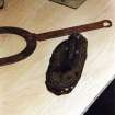
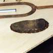
SC 1222394
Camserney Farm, Long House: a child's shoe, found during the conservation work, concealed within a wall
Scotland's Rural Past
2005
© RCAHMS

SC 2152297
Estate Exchange. The Menzies Estate. nos. 1522 & 1523 Sale Brochure 1914. Title: 'The Menzies Estates'. Dalrawer Farm, Domnaheiche, Donafull farm, Donlellan with Burnside, Glassie Farm, Kinardochy Farm, Glengowlandie Farm, Camusericht Farm, Carse Farm, Corrievarkie Lodge, Croft Na Muick Farm, Craiganour Lodge, Shenvail Farm, Frenich Farm, Foss Home farm, Tirinie Farm
Collection of sale catalogues relating to Scottish estates
29/5/1914
© Courtesy of HES (Estates Exchange Collection)

SC 2152303
Estate Exchange. The Menzies Estate. nos. 1522 & 1523 Sale Brochure 1914. Title: 'The Menzies Estates'. Dalrawer Farm, Domnaheiche, Donafull farm, Donlellan with Burnside, Glassie Farm, Kinardochy Farm, Glengowlandie Farm, Camusericht Farm, Carse Farm, Corrievarkie Lodge, Croft Na Muick Farm, Craiganour Lodge, Shenvail Farm, Frenich Farm, Foss Home farm, Tirinie Farm
Collection of sale catalogues relating to Scottish estates
29/5/1914
© Courtesy of HES (Estates Exchange Collection)

SC 2152315
Estate Exchange. The Menzies Estate. nos. 1522 & 1523 Sale Brochure 1914. Title: 'The Menzies Estates'. Dalrawer Farm, Domnaheiche, Donafull farm, Donlellan with Burnside, Glassie Farm, Kinardochy Farm, Glengowlandie Farm, Camusericht Farm, Carse Farm, Corrievarkie Lodge, Croft Na Muick Farm, Craiganour Lodge, Shenvail Farm, Frenich Farm, Foss Home farm, Tirinie Farm
Collection of sale catalogues relating to Scottish estates
29/5/1914
© Courtesy of HES (Estates Exchange Collection)

SC 2152317
Estate Exchange. The Menzies Estate. nos. 1522 & 1523 Sale Brochure 1914. Title: 'The Menzies Estates'. Dalrawer Farm, Domnaheiche, Donafull farm, Donlellan with Burnside, Glassie Farm, Kinardochy Farm, Glengowlandie Farm, Camusericht Farm, Carse Farm, Corrievarkie Lodge, Croft Na Muick Farm, Craiganour Lodge, Shenvail Farm, Frenich Farm, Foss Home farm, Tirinie Farm
Collection of sale catalogues relating to Scottish estates
29/5/1914
© Courtesy of HES (Estates Exchange Collection)

SC 2152318
Estate Exchange. The Menzies Estate. nos. 1522 & 1523 Sale Brochure 1914. Title: 'The Menzies Estates'. Dalrawer Farm, Domnaheiche, Donafull farm, Donlellan with Burnside, Glassie Farm, Kinardochy Farm, Glengowlandie Farm, Camusericht Farm, Carse Farm, Corrievarkie Lodge, Croft Na Muick Farm, Craiganour Lodge, Shenvail Farm, Frenich Farm, Foss Home farm, Tirinie Farm
Collection of sale catalogues relating to Scottish estates
29/5/1914
© Courtesy of HES (Estates Exchange Collection)

SC 2152319
Estate Exchange. The Menzies Estate. nos. 1522 & 1523 Sale Brochure 1914. Title: 'The Menzies Estates'. Dalrawer Farm, Domnaheiche, Donafull farm, Donlellan with Burnside, Glassie Farm, Kinardochy Farm, Glengowlandie Farm, Camusericht Farm, Carse Farm, Corrievarkie Lodge, Croft Na Muick Farm, Craiganour Lodge, Shenvail Farm, Frenich Farm, Foss Home farm, Tirinie Farm
Collection of sale catalogues relating to Scottish estates
29/5/1914
© Courtesy of HES (Estates Exchange Collection)

SC 2152330
Estate Exchange. The Menzies Estate. nos. 1522 & 1523 Sale Brochure 1914. Title: 'The Menzies Estates'. Dalrawer Farm, Domnaheiche, Donafull farm, Donlellan with Burnside, Glassie Farm, Kinardochy Farm, Glengowlandie Farm, Camusericht Farm, Carse Farm, Corrievarkie Lodge, Croft Na Muick Farm, Craiganour Lodge, Shenvail Farm, Frenich Farm, Foss Home farm, Tirinie Farm
Collection of sale catalogues relating to Scottish estates
29/5/1914
© Courtesy of HES (Estates Exchange Collection)

SC 2152332
Estate Exchange. The Menzies Estate. nos. 1522 & 1523 Sale Brochure 1914. Title: 'The Menzies Estates'. Dalrawer Farm, Domnaheiche, Donafull farm, Donlellan with Burnside, Glassie Farm, Kinardochy Farm, Glengowlandie Farm, Camusericht Farm, Carse Farm, Corrievarkie Lodge, Croft Na Muick Farm, Craiganour Lodge, Shenvail Farm, Frenich Farm, Foss Home farm, Tirinie Farm
Collection of sale catalogues relating to Scottish estates
29/5/1914
© Courtesy of HES (Estates Exchange Collection)

SC 2152333
Estate Exchange. The Menzies Estate. nos. 1522 & 1523 Sale Brochure 1914. Title: 'The Menzies Estates'. Dalrawer Farm, Domnaheiche, Donafull farm, Donlellan with Burnside, Glassie Farm, Kinardochy Farm, Glengowlandie Farm, Camusericht Farm, Carse Farm, Corrievarkie Lodge, Croft Na Muick Farm, Craiganour Lodge, Shenvail Farm, Frenich Farm, Foss Home farm, Tirinie Farm
Collection of sale catalogues relating to Scottish estates
29/5/1914
© Courtesy of HES (Estates Exchange Collection)

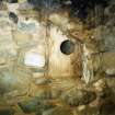
SC 1222385
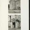
Camserney Farm, Long House, W end: original cruck set on a padstone
Scotland's Rural Past
2005
© RCAHMS

SC 1222386
Camserney Farm, Long House, E end: lath and plaster hanging lum, above the hearth with the backstone in the eastern part of the building
Scotland's Rural Past
2005
© RCAHMS

SC 1222388
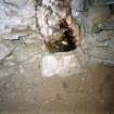
Camserney Farm, Long House, E end: salt box built into the wall near the backstone
Scotland's Rural Past
2005
© RCAHMS


SC 1222395
Camserney Farm, Long House: the worn leather sole of the shoe found in the house during conservation work, showing hand stitching
Scotland's Rural Past
2005
© RCAHMS

SC 2152283
Estate Exchange. The Menzies Estate. nos. 1522 & 1523 Sale Brochure 1914. Title: 'The Menzies Estates'. Dalrawer Farm, Domnaheiche, Donafull farm, Donlellan with Burnside, Glassie Farm, Kinardochy Farm, Glengowlandie Farm, Camusericht Farm, Carse Farm, Corrievarkie Lodge, Croft Na Muick Farm, Craiganour Lodge, Shenvail Farm, Frenich Farm, Foss Home farm, Tirinie Farm
Collection of sale catalogues relating to Scottish estates
29/5/1914
© Courtesy of HES (Estates Exchange Collection)

SC 2152292
Estate Exchange. The Menzies Estate. nos. 1522 & 1523 Sale Brochure 1914. Title: 'The Menzies Estates'. Dalrawer Farm, Domnaheiche, Donafull farm, Donlellan with Burnside, Glassie Farm, Kinardochy Farm, Glengowlandie Farm, Camusericht Farm, Carse Farm, Corrievarkie Lodge, Croft Na Muick Farm, Craiganour Lodge, Shenvail Farm, Frenich Farm, Foss Home farm, Tirinie Farm
Collection of sale catalogues relating to Scottish estates
29/5/1914
© Courtesy of HES (Estates Exchange Collection)

SC 2152294
Estate Exchange. The Menzies Estate. nos. 1522 & 1523 Sale Brochure 1914. Title: 'The Menzies Estates'. Dalrawer Farm, Domnaheiche, Donafull farm, Donlellan with Burnside, Glassie Farm, Kinardochy Farm, Glengowlandie Farm, Camusericht Farm, Carse Farm, Corrievarkie Lodge, Croft Na Muick Farm, Craiganour Lodge, Shenvail Farm, Frenich Farm, Foss Home farm, Tirinie Farm
Collection of sale catalogues relating to Scottish estates
29/5/1914
© Courtesy of HES (Estates Exchange Collection)

SC 2152308
Estate Exchange. The Menzies Estate. nos. 1522 & 1523 Sale Brochure 1914. Title: 'The Menzies Estates'. Dalrawer Farm, Domnaheiche, Donafull farm, Donlellan with Burnside, Glassie Farm, Kinardochy Farm, Glengowlandie Farm, Camusericht Farm, Carse Farm, Corrievarkie Lodge, Croft Na Muick Farm, Craiganour Lodge, Shenvail Farm, Frenich Farm, Foss Home farm, Tirinie Farm
Collection of sale catalogues relating to Scottish estates
29/5/1914
© Courtesy of HES (Estates Exchange Collection)

SC 2152313
Estate Exchange. The Menzies Estate. nos. 1522 & 1523 Sale Brochure 1914. Title: 'The Menzies Estates'. Dalrawer Farm, Domnaheiche, Donafull farm, Donlellan with Burnside, Glassie Farm, Kinardochy Farm, Glengowlandie Farm, Camusericht Farm, Carse Farm, Corrievarkie Lodge, Croft Na Muick Farm, Craiganour Lodge, Shenvail Farm, Frenich Farm, Foss Home farm, Tirinie Farm
Collection of sale catalogues relating to Scottish estates
29/5/1914
© Courtesy of HES (Estates Exchange Collection)

SC 2152335
Estate Exchange. The Menzies Estate. nos. 1522 & 1523 Sale Brochure 1914. Title: 'The Menzies Estates'. Dalrawer Farm, Domnaheiche, Donafull farm, Donlellan with Burnside, Glassie Farm, Kinardochy Farm, Glengowlandie Farm, Camusericht Farm, Carse Farm, Corrievarkie Lodge, Croft Na Muick Farm, Craiganour Lodge, Shenvail Farm, Frenich Farm, Foss Home farm, Tirinie Farm
Collection of sale catalogues relating to Scottish estates
29/5/1914
© Courtesy of HES (Estates Exchange Collection)

SC 2152338
Estate Exchange. The Menzies Estate. nos. 1522 & 1523 Sale Brochure 1914. Title: 'The Menzies Estates'. Dalrawer Farm, Domnaheiche, Donafull farm, Donlellan with Burnside, Glassie Farm, Kinardochy Farm, Glengowlandie Farm, Camusericht Farm, Carse Farm, Corrievarkie Lodge, Croft Na Muick Farm, Craiganour Lodge, Shenvail Farm, Frenich Farm, Foss Home farm, Tirinie Farm
Collection of sale catalogues relating to Scottish estates
29/5/1914
© Courtesy of HES (Estates Exchange Collection)


- Council Perth And Kinross
- Parish Dull
- Former Region Tayside
- Former District Perth And Kinross
- Former County Perthshire
NN84NW 41.00 centred on 81651 49277.
A watching brief was undertaken at Camserney Farm during the construction of a house and access road. No features of archaeological significance were identified.
Sponsor: Scandia Hus Ltd.
Information from RCAHMS (SAH) 30 October 1997.
This site was visited as part of the RCAHMS Scottish Farm Buildings Survey on 15 June 2000.
Information from RCAHMS (ACD ) 24th April 2008
Related sites:
NN84NW 41.01 centred on 816 493 Camserney Farm
NN84NW 41.02 81688 49245 Camserney Farm, Long House
NN84NW 41.03 81600 49247 Camserney Farm, Peat Shed
NN84NW 58 817 494 Camserney Cottages
Reference (2005 - 2005)
Review of historic maps and archive material by Patricia Macinnes (personal research).
Field Visit (2005 - 2005)
Photographic survey by Patricia Macinnes (personal research).

