|
Photographs and Off-line Digital Images |
E 54547 CN |
RCAHMS Aerial Photography |
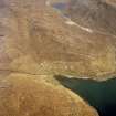
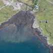
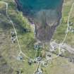
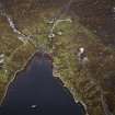
Oblique aerial view centred on the remains of the whaling station with the remains of the township adjacent, taken from the SSW. |
25/9/2004 |
Item Level |
|
|
Photographs and Off-line Digital Images |
E 54548 CN |
RCAHMS Aerial Photography |
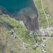
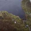
Oblique aerial view centred on the remains of the whaling station with the remains of the township adjacent, taken from the NE. |
25/9/2004 |
Item Level |
|
|
Photographs and Off-line Digital Images |
E 54549 CN |
RCAHMS Aerial Photography |
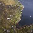
Oblique aerial view centred on the remains of the whaling station with the remains of the township adjacent, taken from the NNW. |
25/9/2004 |
Item Level |
|
|
Photographs and Off-line Digital Images |
E 54550 CN |
RCAHMS Aerial Photography |
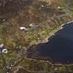
Oblique aerial view centred on the remains of the whaling station with the remains of the township adjacent, taken from the WNW. |
25/9/2004 |
Item Level |
|
|
Photographs and Off-line Digital Images |
E 63593 CN |
RCAHMS Aerial Photography |
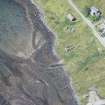
Oblique aerial view centred on the township and the remains of the buildings with the township adjacent, taken from the SW.
|
23/4/2005 |
Item Level |
|
|
Photographs and Off-line Digital Images |
E 63589 CN |
RCAHMS Aerial Photography |
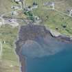
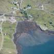
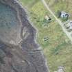
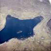
General oblique aerial view centred on the township with the quarry adjacent, taken from the WSW.
|
23/4/2005 |
Item Level |
|
|
Photographs and Off-line Digital Images |
E 63590 CN |
RCAHMS Aerial Photography |
General oblique aerial view centred on the township with the quarry adjacent, taken from the WSW.
|
23/4/2005 |
Item Level |
|
 |
On-line Digital Images |
SC 1007616 |
RCAHMS Aerial Photography |
General oblique aerial view centred on the township with the quarry adjacent, taken from the WSW.
|
23/4/2005 |
Item Level |
|
 |
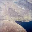
On-line Digital Images |
DP 221676 |
RCAHMS Aerial Photography Digital |
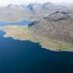
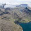
General oblique aerial view of Loch a Siar and Ardhasaig with An Clisean beyond, looking NNE. |
18/9/2015 |
Item Level |
|
 |
On-line Digital Images |
DP 235684 |
Historic Environment Scotland |
Oblique aerial view. |
3/6/2016 |
Item Level |
|
 |
On-line Digital Images |
DP 235685 |
Historic Environment Scotland |
Oblique aerial view. |
3/6/2016 |
Item Level |
|
 |
On-line Digital Images |
DP 235689 |
Historic Environment Scotland |
Oblique aerial view. |
3/6/2016 |
Item Level |
|
 |
On-line Digital Images |
DP 235698 |
Historic Environment Scotland |
Oblique aerial view. |
3/6/2016 |
Item Level |
|
 |
On-line Digital Images |
DP 235699 |
Historic Environment Scotland |
Oblique aerial view. |
3/6/2016 |
Item Level |
|
 |
On-line Digital Images |
DP 235700 |
Historic Environment Scotland |
Oblique aerial view. |
3/6/2016 |
Item Level |
|
 |
On-line Digital Images |
DP 235701 |
Historic Environment Scotland |
Oblique aerial view. |
3/6/2016 |
Item Level |
|
 |
On-line Digital Images |
DP 235779 |
Historic Environment Scotland |
Oblique aerial view. |
3/6/2016 |
Item Level |
|
 |
On-line Digital Images |
SC 1690724 |
RCAHMS Aerial Photography |
General oblique aerial view centred on the township with the quarry adjacent, taken from the WSW.
|
23/4/2005 |
Item Level |
|
 |
On-line Digital Images |
SC 1690726 |
RCAHMS Aerial Photography |
Oblique aerial view centred on the township and the remains of the buildings with the township adjacent, taken from the SW.
|
23/4/2005 |
Item Level |
|
 |
On-line Digital Images |
SC 1691891 |
RCAHMS Aerial Photography |
Oblique aerial view centred on the remains of the whaling station with the remains of the township adjacent, taken from the SSW. |
25/9/2004 |
Item Level |
|
 |
On-line Digital Images |
SC 1691892 |
RCAHMS Aerial Photography |
Oblique aerial view centred on the remains of the whaling station with the remains of the township adjacent, taken from the NE. |
25/9/2004 |
Item Level |
|
 |
On-line Digital Images |
SC 1691893 |
RCAHMS Aerial Photography |
Oblique aerial view centred on the remains of the whaling station with the remains of the township adjacent, taken from the NNW. |
25/9/2004 |
Item Level |
|
 |
On-line Digital Images |
SC 1691894 |
RCAHMS Aerial Photography |
Oblique aerial view centred on the remains of the whaling station with the remains of the township adjacent, taken from the WNW. |
25/9/2004 |
Item Level |
|
 |
On-line Digital Images |
SC 1692005 |
RCAHMS Aerial Photography |
General oblique aerial view centred on the township with the quarry adjacent, taken from the WSW.
|
23/4/2005 |
Item Level |
|


