
Cherry Island, Loch Ness


Crannog (Period Unassigned)
Site Name Cherry Island, Loch Ness
Classification Crannog (Period Unassigned)
Alternative Name(s) Inchnacardoch Bay; Eilean Muireach; Murdoch's Island
Canmore ID 12226
Site Number NH31SE 1
NGR NH 38603 10278
Datum OSGB36 - NGR
Permalink http://canmore.org.uk/site/12226


- Council Highland
- Parish Boleskine And Abertarff
- Former Region Highland
- Former District Inverness
- Former County Inverness-shire
NH31SE 1 3860 1025
(NH 3860 1025) Cherry Island (NAT)
Crannog (NR)
(Undated) annotation on OS map.
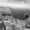
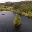
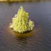
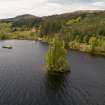
Cherry Island, properly Eilean Muireach, Murdoch's Island, was inspected in August 1908 when the waters were low, with the aid of a diving suit. It was found to be of artificial construction.
It consisted of a flooring of oak beams, fastened together (and visible on the N side of the island), overlaid with a pile of rubble, which was covered, in turn, with larger stones. Tree trunks, from which spars ran into the rubble, were set at intervals round the circumference of the rubble.
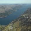
A causeway could be traced, running from the NW corner of the island, straight in the direction of three large boulders on the mainland, which were known from tradition to be part of the approach from the land side. It is not known if this was the original approach, since a castle is known to have existed on the island in the 15th century. If the island was used as a hunting seat, the nearby Eilean nan Con (NH 3875 1040) was probably used to accommodate the dogs.
At the SE corner of the island a long, narrow ridge of stones has evidently been a breakwater to protect the stonework. A mass of vitrified matter lay on the bed of the loch about 20 yds from the island.
Prior to the formation of the Caledonian Canal at the beginning of the 19th century, the level of Loch Ness was 6' lower than today, so the island would have measured about 180' by 168', instead of the 60' by 48' it is now.
The stumps of some old trees, killed by the raising of the water can be mistaken for piles.
O Blundell 1909.
Cherry Island, a crannog composed of loose rubble stones. At the time of investigation the level of the loch was high and no oak piles, causeway, or vitrified matter could be seen. There are no remains of a hunting seat. Eilean nan Con, 150.0m NE of the island, is submerged and marked by a post.
Visited by OS (NKB) 12 October 1970.
Scheduled as Cherry Island, crannog, Inchnacardoch Bay, Loch Ness.
Information from Historic Scootland, scheduling document dated 10 december 2001.

