
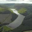
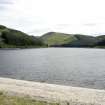
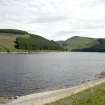
Talla Reservoir


Reservoir (19th Century)
Site Name Talla Reservoir
Classification Reservoir (19th Century)
Alternative Name(s) Talla Water; Talla Waterworks Scheme
Canmore ID 122232
Site Number NT12SW 17
NGR NT 1200 2140
NGR Description Centred NT 1200 2140
Datum OSGB36 - NGR
Permalink http://canmore.org.uk/site/122232


- Council Scottish Borders, The
- Parish Tweedsmuir
- Former Region Borders
- Former District Tweeddale
- Former County Peebles-shire
NT12SW 17.00 centred 1200 2140
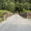
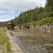
NT12SW 17.01 NT 10451 22820 to NT 10740 22891 Dam
NT12SW 17.02 NT 10726 22819 Inner Shaft
NT12SW 17.03 NT 10795 22917 Centre Shaft
NT12SW 17.04 NT 10654 23030 Outer Shafts
NT12SW 17.05 Centred NT 10629 23079 Waterworks
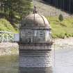
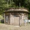
NT12SW 17.06 NT 10648 23099 Measuring House
NT12SW 17.07 NT 10707 23120 Keeper's House (Victoria Lodge)
NT12SW 17.08 NT 10445 23166 Workers' Houses
For enclosure and other structures (centred NT 1097 2178) submerged by the reservoir, see NT12SW 22.
For associated aqueduct (NT 10648 23099 to NT c. 271 690), see NT12SW 38.
For associated construction railway, see NT12NW 57.00, NT12SW 37 and NT13SW 85.00: summary information on the railway as a whole will be found on NT12SW 37.
For associated Edinburgh, Liberton, Alnwickhill Waterworks (centred NT 27199 69001), see NT26NE 87.00.
Talla Reservoir
Top water level 290 metres above Newlyn datum [NAT]
(name centred NT 117 215)
OS 1:10,000 map, 1989.
Developed under the name of the New Water Supply by the Edinburgh and District Water Trust, the Talla Scheme was adopted on 11 October 1894. It comprised a storage reservoir, a service reservoir and filter, main and branch aqueducts, and a railway from Broughton Station to Talla. The authorising Act received the Royal Assent on 30 May 1895.
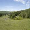
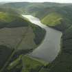
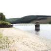
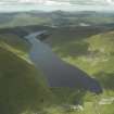
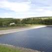
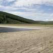
The length of the loch at maximum is about 2.5 miles (12.1km), and the greatest depth of water (close to the dam) about 80ft (24.4m). The total capacity is about 2,800 million gallons (12,727,000,000 lit).
W A Tait 1905.
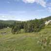
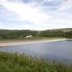
This reservoir was formed by damming the Talla Water, a tributary of the Tweed, and lies entirely within the parish of Tweedsmuir. It forms a major element of the water supply for Edinburgh, being built as a major element of the early 20th century development of the system.
Information from RCAHMS (RJCM), 28 October 2005.
Vertical air photographs: 541/A/530 3023-4 and 4023-4, flown 14 May 1950.
Information from RCAHMS (KM), 29 November 2005.
Publication Account (2007)
This reservoir is formed by an earth dam 1050 ft long and of maximum height 80 ft impounding up to 2800 million gallons of water. The top water level is 950 ft above Ordnance Datum and the dam side slopes are 1 in 4
upstream and 1 in 3 downstream. Water is conveyed 35 miles to Alnwickhill, Edinburgh by the Talla Aqueduct.
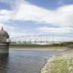
A 10 mile long standard gauge temporary railway was constructed from the Caledonian Railway at Broughton
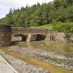
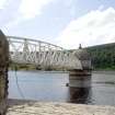
for the conveyance of materials. Much of the formation level of this railway and its iron truss bridges of 100 ft
span over the Tweed, which also carried the aqueduct, and of 60 ft span over the Biggar Water, can still be seen. The line had a ruling gradient of 1 in 50.
The engineers were J. & A. Leslie & Reid of Edinburgh. Construction was let in about 50 separate contracts, but the greater part of the works were carried out by James Young & Sons and John Best, both of Edinburgh, and Robert McAlpine & Sons of Glasgow. The total cost from 1895 to completion in 1905 was £1.25m. In the 1950s and 1960s the tributaries Menzion and Fruid were developed to augment the supply.
R Paxton and J Shipway 2007
Reproduced from 'Civil Engineering heritage: Scotland - Lowlands and Borders' with kind permission from Thomas Telford Publishers.

