
Pricing Change
New pricing for orders of material from this site will come into place shortly. Charges for supply of digital images, digitisation on demand, prints and licensing will be altered.
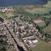
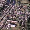
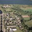
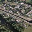
Fort Augustus, Lovat Arms Hotel, Kiliwhimin Barracks


Artillery Fortification (18th Century)
Site Name Fort Augustus, Lovat Arms Hotel, Kiliwhimin Barracks
Classification Artillery Fortification (18th Century)
Alternative Name(s) Kilcumein Barracks; Kiliwhimin Fort; Kilwhimen Barracks; Barracks Of Kiliwhiman
Canmore ID 12207
Site Number NH30NE 5
NGR NH 37774 09050
Datum OSGB36 - NGR
Permalink http://canmore.org.uk/site/12207


- Council Highland
- Parish Boleskine And Abertarff
- Former Region Highland
- Former District Inverness
- Former County Inverness-shire
NH30NE 5 37774 09050.
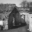
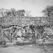
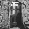
(NH 3777 0905) Kiliwhimin, built in 1718, was a small fort of the standard Hanoverian government type. In plan it was similar to, but slightly larger than, Ruthven Barracks (NN 79 NE1) i.e. square, with a projecting tower at each of two diagonally opposite corners.
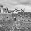
The fort was considered too far from the water, and was superseded in 1727 by Fort Augustus (Built 1729-42: NH30NE 6). In 1745 it was taken over by the Jacobites who, from it, bombarded and reduced Fort Augustus. The south (sic) wall of Kiliwhimin Fort stands in the back yard of the Lovat Arms Hotel, Fort Augustus.
S Cruden 1960
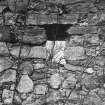
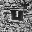
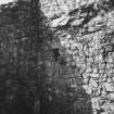
The remains of Kiliwhimin Fort consist of the west curtain wall, 36.5m long, and 4.0m high, pierced by a central gateway and ten gun embrasures, some of which are blocked, which now forms part of the rear court of the Lovat Arms Hotel.
Visited by OS (N K B) 28 April 1964.
Scheduled as Kilwhimen (or Kilcumein) Barracks, Fort Augustus.
Information from Historic Scotland, scheduling document dated 25 October 2001.
The Barracks of Kiliwhiman, built 1718 (now part of the Lovat Arms Hotel - NH30NE 5) were replced by the 'modern' Fort Augustus, built 1729-42 (Fort Augustus, Old Fort Augustus). The remains of this Fort Auguutus are incorporated into Fort Augustus Abbey and Church (NH30NE 6).
Architect: James Smith 1718-1719
Fort Augustus - Inverness-shire
Said to have occupied the area on which Fort Augustus was built, between the Rivers Tarfe and Oich where the enter the South end of Loch Ness.
In the Natioanl Library of Scotland is a series of Military Maps and Drawings (many are coloured) of the Board of Ordnance, relating to the Works executed in the 18th Century, Reference "MSS. 1645-1652). these Drawings include, in Case, or Volume, No.1648, the following relating to Kiliwhiman:-
Number. Year.
Z.3/8. No date. "Situation of Barrack at Kiliwhiman" - at the debouching of the River of Oich on Loch Ness.
Z.3/9. 1719. "A large plan of "Kiliwhiman", 1719. Shews its situation.
Z.3/10. No date. "Kiliwhiman", Plan, Sections, and Elevations, with Explanation. Scale 10 Feet to an Inch. There are copies.
" No date. A small Engraving of the Plan, Sections, and Elevations of Killewhiman.
Z.3/11. No date. "Explanation of the Plan, Section and Elevation of the Barracks at Inversnait and at Kiliwhiman". Shews small scale plans and elevations and Sections to 30 Feet to an Inch. There is a copy.
This Drawing is also entered under Inversnait.
Z3/12. 1723. "Plan Section and Elevation of the Barracks at Killiwhiman, "with a particular Plan
and Section of the Cistern". With Explanation. Scale 30 Feet to an Inch for General drawing and 10 Feet to about 3 Inches for Cistern Detail. Signed by J. Remer, Engineer. 1723. There are 2 copies.
Z.3/18. No date. "Killewhiman, Inversnait. Ruthven of Badenoch, and Bernera". Plans. Sections, and Elevations of the four Barracks to the small scale of 30 Feet to an Inch. With Explanations. There are copies.
Also indexed under the other Barracks named.
Non-Guardianship Sites Plan Collection, DC28083-DC28090, 1719, 1723 & 1725.

