
Following the launch of trove.scot in February 2025 we are now planning the retiral of some of our webservices. Canmore will be switched off on 24th June 2025. Information about the closure can be found on the HES website: Retiral of HES web services | Historic Environment Scotland
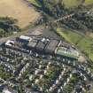
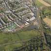
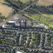
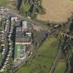
Markinch Railway Viaduct


Railway Viaduct (19th Century)
Site Name Markinch Railway Viaduct
Classification Railway Viaduct (19th Century)
Alternative Name(s) River Leven; Markinch Viaduct
Canmore ID 121988
Site Number NO20SE 179
NGR NO 29839 01042
Datum OSGB36 - NGR
Permalink http://canmore.org.uk/site/121988


- Council Fife
- Parish Markinch
- Former Region Fife
- Former District Kirkcaldy
- Former County Fife
NO20SE 179 29839 01042
Viaduct [NAT]
OS (GIS) MasterMap, July 2010.
Not to be confused with Balbirnie railway viaduct (NO 29032 01221 to NO 28970 011570, for which see NO20SE 182.
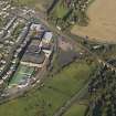
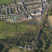
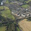
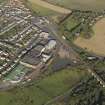
(Location cited as N0 298 010). Markinch Viaduct, opened 1847 by the Edinburgh and Northern Rly. A handsome 10-span viaduct, with small single semicircular arches at each end and 8 main arches, all semicircular. The arch rings are of dressed stone, rustic ashlar, and the spandrels of coursed rubble. Iron tie-rods have been inserted in the spandrels.
J R Hume 1976.
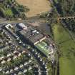
This major viaduct carries the Kircaldy-Ladybank portion of the Aberdeen-Edinburgh main line high above the River Leven, a mill lade, and the A911 public road. It remains in regular use by passenger traffic.
Information from RCAHMS (RJCM), 2 July 2010.

