 |
On-line Digital Images |
SC 505343 |
RCAHMS Aerial Photography |
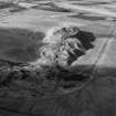
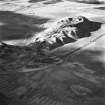
Tarbrax Shale-Oil Works and Viewfield Shale Pit, oblique aerial view, taken from the E, showing the massive bing of the shale-oil mine in the centre of the photograph, between a tramway, on the left, and the Tarbrax Branch of the Caledonian Railway on the right. Viewfield shale-oil mine is visible in the top right-hand corner. |
8/2/1995 |
Item Level |
|
 |
On-line Digital Images |
SC 659026 |
Papers of Professor John R Hume, economic and industrial historian, Glasgow, Scotland |
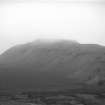
View showing shale bing |
1965 |
Item Level |
|
 |
On-line Digital Images |
SC 1730879 |
RCAHMS Aerial Photography |
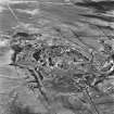
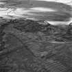
Tarbrax Shale-Oil Works, oblique aerial view, taken from the SSW, showing one massive shale bing of the shale-oil mine in the centre of the photograph, with the Tarbrax Branch of the Caledonian Railway curving around it. A further, smaller, shale bing overlies an area of rig in the top half, and the remains of an engine house and dam are visible in the centre right. |
8/2/1995 |
Item Level |
|
 |
On-line Digital Images |
SC 1731228 |
RCAHMS Aerial Photography |
Tarbrax Shale-Oil Works, oblique aerial view, taken from the E, showing the massive bing of the shale-oil mine in the top right-hand corner of the photograph, between a tramway, on the left, and the Tarbrax Branch of the Caledonian Railway on the right. A further shale bing is visible in the bottom half, overlying an area of rig. |
8/2/1995 |
Item Level |
|
 |
On-line Digital Images |
SC 1731229 |
RCAHMS Aerial Photography |
Tarbrax Shale-Oil Works, oblique aerial view, taken from the ENE, showing the massive bing of the shale-oil mine in the top half of the photograph, between a tramway, on the left, and the Tarbrax Branch of the Caledonian Railway on the right. A further shale bing is visible in the bottom half, overlying an area of rig. |
8/2/1995 |
Item Level |
|
 |
On-line Digital Images |
SC 1731230 |
RCAHMS Aerial Photography |
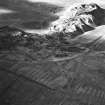
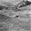
Tarbrax Shale-Oil Works, oblique aerial view, taken from the NE, showing one massive bing of the shale-oil mine in the centre of the photograph, with a tramway running off into the top right-hand corner, and the Tarbrax Branch of the Caledonian Railway running alongside it. A further shale bing, and the ruins of an engine house and dam, are visible in the bottom half, overlying an area of rig. |
8/2/1995 |
Item Level |
|
 |
On-line Digital Images |
SC 1731247 |
RCAHMS Aerial Photography |
Tarbrax Shale-Oil Works, oblique aerial view, taken from the ENE, showing one of the massive shale bings associated with the shale-oil mine at the top of the photograph, with a tramway running alongside it to the left, and the Tarbrax Branch of the Caledonian Railway to the right. A second, smaller, shale bing overlies an area of rig in the bottom half. |
8/2/1995 |
Item Level |
|


