
Eilean Mhic Raonuill


Crannog (Period Unassigned)
Site Name Eilean Mhic Raonuill
Classification Crannog (Period Unassigned)
Alternative Name(s) Loch Lundie
Canmore ID 12152
Site Number NH20SE 3
NGR NH 2975 0371
Datum OSGB36 - NGR
Permalink http://canmore.org.uk/site/12152


- Council Highland
- Parish Kilmonivaig
- Former Region Highland
- Former District Lochaber
- Former County Inverness-shire
NH20SE 3 2975 0371.
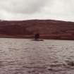
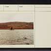
MacRanald's Island - "Eilean Mhic Rhaonuill", Loch Lundie: Allan Mac Ranald of Lundie, Allan of the Red Jacket, who flourished about the beginning of the seventeenth century lived on a small island on Loch Lundie. The island, composed of loose stones barely 60ft in diameter, is probably artificial.
E C Ellice 1931
According to Blundell, it measured 40ft by 35ft and stood 3 1/2 ft above the water. No woodwork could be found in it.
O Blundell 1910
This island, at NH 2975 0371, is composed of small stones and now measures only 8.0m in diameter and 0.7m above water level. It is surmounted by a small modern cairn and a single coniferous tree. No evidence of a structure on the island or causeway to it could be
found.
Visited by OS (R D) 28 May 1964
The probable crannog is situated at NH 2975 0371 and is as described by the previous investigator. Eilean Mhic Raonuill, as shown on the OS 6" map at NH 2990 0386, is a natural island, as are the other islands in that part of the loch.
Surveyed at 1/10,000.
Visited by OS (J B) 17 May 1979
Site recorded during a short-notice pre-afforestation survey was undertaken of 1sq km of land at Faichemard. The survey area is located immediately to the W and SW of Loch Lundie.
A small island (NH 2986 0379) on the E side of Loch Lundie, believed locally to be of artificial construction, may also be associated with medieval or earlier activity in the area.
A full report has been lodged with the NMRS.
Sponsor: Historic Scotland
C Lowe 1998

