
Thornton Marshalling Yard


Marshalling Yard (20th Century)
Site Name Thornton Marshalling Yard
Classification Marshalling Yard (20th Century)
Alternative Name(s) Redford Yard; Strathore
Canmore ID 121367
Site Number NT29NE 14
NGR NT 2600 9700
NGR Description Centred NT 2600 9700
Datum OSGB36 - NGR
Permalink http://canmore.org.uk/site/121367


- Council Fife
- Parish Kinglassie
- Former Region Fife
- Former District Kirkcaldy
- Former County Fife
NT29NE 14.00 centred 2600 9700
NT29NE 14.01 NT 2560 9700 Signal Box (Hump box)
NT29NE 14.02 NT 2653 9705 Signal Box
For adjacent Rothes colliery, see NT29NE 8.
Location formerly entered as Centred NT 260 970.
Extends into Kirkcaldy and Dysart parish (on E side).
Built as part of 1950's modernisation plan.
(Undated) information in NMRS.
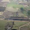
The provision of new and technologically advanced marshalling yards in Scotland was a major feature of the 1955 Modernisation Plan for British Railways, being intended to replace a far greater number of smaller yards of simpler design and more limited capacity. The five Scottish locations selected for construction or development were Thornton in Fife, Millerhill (NT37SW 1127) in Lothian, Perth (NO12NW 104), Cadder (NS67SW 55) to the NE of Glasgow, and Mossend (NS76SW 159) in South Lanarkshire. Of these, the yards at Perth and Thornton may be seen as a highly significant forerunners to the larger and later English yards.
This new yard was laid out in open country, to the W of Thornton Junction (station: NT29NE 4) and on the 'down' (N) side of the Dunfermline-Thornton line. It was primarily intended to handle coal from the Fife coalfield, which was then being rapidly developed in preference to the exploitation of deposits elsewhere. Increased coal traffic was expected generate a daily throughput of up to 3000 wagons, and the yard replaced facilities at Thornton Station, Burntisland, Methil and Townhill which had a total daily capacity of only about 900.
Some 78 acres (31.6 ha) of land were purchased in 1948, and construction of the yard began in 1953; it was opened in November 1956. The daily throughput of wagons increased to 1800, but the planned capacity was never reached. A daily wagon throughput of 10,150 was achieved in 1958, but a decreasing requirement for wagonload freight in general and coal in particular prompted rationalisation. The hump and reception sidings were lifted in the early 1970's, and only sparse services survived in 1986, the yard being largely used as a secondary yard for Speedlink traffic.
This was the first yard at which automatic hump shunting equipment of American type and based around the use of radar was introduced. The hump was built higher than usual, allowing room for a longer stretch of track at the required gradient. Two sets of retarders (rather than the single set of earlier yards) were installed between three successive sets of points ('king', 'queen' and 'jack'). Other innovations included closed circuit television, modern lighting masts, and a turntable-based locomotive stabling point.
The layout of this yard was unusual in that both 'up' and 'down' traffic was handled in the same set of sidings, a somewhat tortuous entry route being provided for 'up' traffic. Reception sidings (at the West end) led over the hump to 35 sorting sidings, which could hold 2311 wagons in all, and varied in length between 55 and 78 standard length units.
(Illustrated with numerous photographs, and schematic plans as 1958 and 1986).
M Rhodes 1988.

