
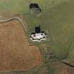
Castletown


Farmstead (Period Unassigned)
Site Name Castletown
Classification Farmstead (Period Unassigned)
Alternative Name(s) Cockbridge Farm; Corgarff Castle
Canmore ID 121298
Site Number NJ20NE 81
NGR NJ 2543 0877
Datum OSGB36 - NGR
Permalink http://canmore.org.uk/site/121298


- Council Aberdeenshire
- Parish Strathdon
- Former Region Grampian
- Former District Gordon
- Former County Aberdeenshire
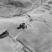
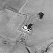
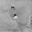
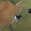
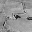
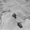
The remains of a farmstead comprising a building and an enclosure are situated on a terrace in the angle of the approach road to Corgarff Castle. An L-shaped building is depicted as roofed at this location on the first edition of the OS six-inch map, and is annotated as Castletown. By the turn of the century, the site is shown as unimproved ground and the placename has been assigned to two roofed buildings a short distance to the west.
Text prepared by RCAHMS as part of the Accessing Scotland's Past project
NJ20NE 81 2543 0877
What may be the remains of a farmstead are situated on a terrace in the angle of the approach road to Corgarff Castle (NJ20NE 1.00). It comprises possible traces of a building set on the W side of an enclosure. An L-shaped structure is depicted as roofed on the first edition of the OS 6-inch map (Aberdeenshire 1869, sheet LXVIII), but it had been removed by the end of the 19th century (2nd edition map 1902, sheet LXVIII).
Visited by RCAHMS (JRS, SH), 11 August 1997.

