
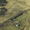
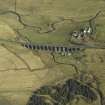
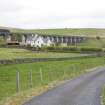
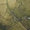
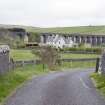
Shankend


Farmhouse (Period Unassigned), Farmstead (Period Unassigned)
Site Name Shankend
Classification Farmhouse (Period Unassigned), Farmstead (Period Unassigned)
Canmore ID 120946
Site Number NT50NW 38
NGR NT 5227 0595
Datum OSGB36 - NGR
Permalink http://canmore.org.uk/site/120946


- Council Scottish Borders, The
- Parish Cavers
- Former Region Borders
- Former District Roxburgh
- Former County Roxburghshire
NT50NW 38 5227 0595
During the First World War the farmsteading was occupied by German Prisoners-of-war, some of whom are buried in the grounds (A Wham 2004).

