
Following the launch of trove.scot in February 2025 we are now planning the retiral of some of our webservices. Canmore will be switched off on 24th June 2025. Information about the closure can be found on the HES website: Retiral of HES web services | Historic Environment Scotland
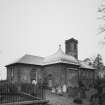
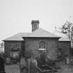
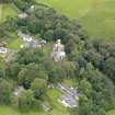
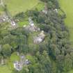
Durisdeer Parish Church, Churchyard


Burial Ground (Period Unassigned)
Site Name Durisdeer Parish Church, Churchyard
Classification Burial Ground (Period Unassigned)
Alternative Name(s) Durisdeer Churchyard; Graveyard
Canmore ID 120894
Site Number NS80SE 12.02
NGR NS 8942 0376
Datum OSGB36 - NGR
Permalink http://canmore.org.uk/site/120894


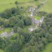


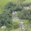


- Council Dumfries And Galloway
- Parish Durisdeer
- Former Region Dumfries And Galloway
- Former District Nithsdale
- Former County Dumfries-shire
See also NS80SE 12 00 for Durisdeer Parish Church
NS80SE 12 01 for Durisdeer Parish Church, Queensberry Mausoluem and Douglas Burial Vault

