
Following the launch of trove.scot in February 2025 we are now planning the retiral of some of our webservices. Canmore will be switched off on 24th June 2025. Information about the closure can be found on the HES website: Retiral of HES web services | Historic Environment Scotland
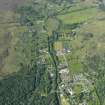
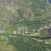
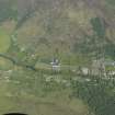
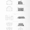
Strontian Church


Burial Ground (19th Century), Church (19th Century) (1827)
Site Name Strontian Church
Classification Burial Ground (19th Century), Church (19th Century) (1827)
Alternative Name(s) Telford Church
Canmore ID 120651
Site Number NM86SW 4
NGR NM 81560 62400
Datum OSGB36 - NGR
Permalink http://canmore.org.uk/site/120651


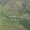
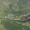
- Council Highland
- Parish Ardnamurchan
- Former Region Highland
- Former District Lochaber
- Former County Argyll
Note (3 February 2025)
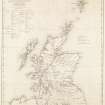
A church is depicted on the 1st edition of the OS 25-inch map (1873) - Argyllshire and Buteshire XXVIII.5 (Ardnamurchan). A burial ground is depcited on the 2nd edition of the OS 25-inch map (1898) - Argyllshire XXVIII.5.
Information from HES (D Watson) 3 February 2025

