Stoer Parliamentary Church
Cemetery (Period Unassigned), Church (19th Century)
Site Name Stoer Parliamentary Church
Classification Cemetery (Period Unassigned), Church (19th Century)
Alternative Name(s) Rhuestore; Stoer Parish Church; Stoer, Telford Church
Canmore ID 120635
Site Number NC02NW 12
NGR NC 04053 28536
Datum OSGB36 - NGR
Permalink http://canmore.org.uk/site/120635
- Council Highland
- Parish Assynt
- Former Region Highland
- Former District Sutherland
- Former County Sutherland
For Stoer parish manse (NC 0386 2860), see NC02NW 13.
Telford church.
S Hackett and N Livingston 1984.
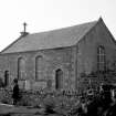
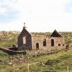
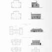
Standard Parliamentary T-plan church; coursed rubble, contrasting tooled dressings. Depressd arched paired doors in outer bays of south elevation;
similarly detailed paired centre windows; similar single windows in end gables and rear wing. Gutted and roofless. Church stands in small burial ground enclosed by rubble drystone wall.
"Quoad sacra" parish of Stoer established in 1834 (Historic Environment Scotland List Entry)
Earth Resistance Survey (1 July 2014)
NC 04053 28536 Stoer Church is a Standard Parliamentary T-plan church which stands in a small burial ground enclosed by rubble dry stone walls. The church is currently ruinous. A resistance survey was undertaken, on 1 July 2014, within the graveyard surrounding the derelict church with the aim of locating unmarked graves and buried gravestones prior to
redevelopment of the site.
Although the whole graveyard was investigated, the area of interest was the NW corner, where it is planned to run services to and from the redeveloped church. Anomalies suggestive of potential burials have been noted immediately to the N of the limit of visible burials (grave markers) in the NW corner of the graveyard. Micro-topographic changes in the turf coincide with the N and W edge of these resistance anomalies. There is no evidence in the data for further burials to the N or W of these suspected burials. Further anomalies in this area are believed to be due to variations in the depth of bedrock, which is outcropping in places.
Archive: Rose Geophysical Consultants
Funder: Mr G Morgan
Susan Ovenden - Rose Geophysical Consultants
(Source: DES)
Photographic Survey (9 August 2019)
NC 04053 28536 A detailed photographic survey was carried out in advance of restoration and conversion of a disused Thomas Telford church at Stoer (Canmore ID: 120635). Stoer Church is a standard Parliamentary T-plan church which stands in a small rectangular-shaped burial ground enclosed by rubble drystone walls. The church is ruinous and the building and burial ground were Listed at Category C in 1971. However, the church and burial ground were re-assessed by Historic Environment Scotland in 2017 and they were assessed as no longer meeting the criteria for Listing. The photographic survey was carried out on the 9 August 2019 and a total of 130 colour digital images were taken.
Generally, the main fabric of the church construction comprises dressed sandstone blocks, with neat courses laid out in the lower sections of the wall elevations (1.5-2.0m high), with more random courses of stonework above to the roof-plate level. Sandstone pinning has been used in joints between the sandstone blocks, while lime mortar has been used as the matrix. Quoins have only been used on the outside corners of the structure and these comprise a different coloured stone. Interestingly, the S and W external walls have been well-built using rectangular, dressed blocks of stone; but the other faces comprise a more random build using different sizes of stone, which have required the sandstone pinning. The remains of rough-cast harling were noted on some outside elevations of the church walls (but not on the front south face), indicating that it had been covered and possibly whitewashed.
The arches for door and window apertures are also well-constructed using dressed stone and with central ‘key’ stones. The window and door apertures are flared inwards, while window sills and door threshold slabs comprise a lighter-coloured, soft stone – most likely a limestone. Some sections of the iron window frames survive in the SW window, on the south face of the church – a feature seen at other Parliamentary churches in Scotland. Threshold stones were noted outside the two entrances. The windows and doors of the church have been boarded for security purposes as a part of the renovation programme.
Concrete slabs, located on the pitched wall-heads of the building, would have retained the slates of the roof. A concrete cross is mounted on a pedestal on the top of the west gable, while a simple finial is mounted on the east gable. However, during the photographic survey, the remains of the bell-housing/belfry and elaborate finial were identified lying against the inside of the sandstone enclosure wall, in the SW corner of the enclosing burial ground. This looks similar in design to the bell-housings seen on other Telford churches including Ullapool. A number of roofing slates were noted lying adjacent to the south wall of the church.
The internal walls, which would have been hidden within the gable space of the church, display a poorer build finish and would not have been clad in wood. Wooden dwangs were noted knocked into gaps within the masonry on the internal wall faces up to the main roof-plate height (but not the gable spaces), suggesting that the church was clad internally in wood panelling. The internal walls also have sockets for large crossbeams, which would have supported the upper galleries in the N, E and W wings of the church – similar to those seen at the renovated Telford church in Ullapool. Two alignments of sockets in the wall also appear to show where the pulpit was mounted, on the inside face of the south wall.
Two areas of stone paving, located at the corners of the S/W walls and S/E walls – just inside and to the E and W of the two main entrances into the church, may indicate the location of the stairwells accessing the upper galleries. The remains of wooden cladding and some structural timbers, along with some cast-iron drain furniture were noted within the interior of the church; but it is obvious that much robbing of structural materials has taken place in the past, resulting in a relatively empty shell.
The external enclosure wall surrounding the church and burial ground comprises a random build using sandstone blocks with copping stones to the top. In the NE corner, the enclosing wall has been constructed over outcropping bedrock and bridging stones have been used in some areas to provide level platforms off which to build the wall. A central entrance with the remains of a decorative iron gate aligns with the centre of the south face of the church. The remains of iron posts, set into the top of the enclosure wall with mortar, survive around parts of the perimeter wall, along with some strands of the wire fencing. Two square pillars lie to each side of the entrance gate, while a long sandstone slab is set into the enclosure wall to the west, forming a step/stile into the burial ground enclosure.
A number of upright grave markers are located within the burial ground, as well as several prone grave marker stones. Quite recently, a large number of flat grave slabs have been uncovered from below the turf and it is thought that this was carried out by a local inhabitant of Stoer. Generally, the grave markers are located to the front two thirds of the burial enclosure space, which is due to sandstone bedrock outcropping in the NW and NE corners. The locations of potentially unmarked graves are displayed by depressions in the ground and some of these have been confirmed during the geophysics survey. It is possible that additional soil was incorporated into the burial ground to provide sufficient depth to contain the grave pits. No burials appear to be present within the church interior.
Archive: Highland Council HER and NRHE (intended)
Funder: Private individual
Steven Birch - West Coast Archaeological Services
(Source: DES Vol 20)


