
Following the launch of trove.scot in February 2025 we are now planning the retiral of some of our webservices. Canmore will be switched off on 24th June 2025. Information about the closure can be found on the HES website: Retiral of HES web services | Historic Environment Scotland
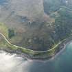
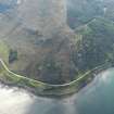
Creag Mhor, Gruinard


Hut Circle(S) (Prehistoric)
Site Name Creag Mhor, Gruinard
Classification Hut Circle(S) (Prehistoric)
Canmore ID 12061
Site Number NG99SE 1
NGR NG 96165 92803
NGR Description NG 96165 92803 and NG 9610 9286
Datum OSGB36 - NGR
Permalink http://canmore.org.uk/site/12061


- Council Highland
- Parish Lochbroom
- Former Region Highland
- Former District Ross And Cromarty
- Former County Ross And Cromarty
NG99SE 1 9616 9280 and NG 9610 9286
Some 200 metres to the north of Creag Mhor, between the 100 ft and 200 ft contours, on the steep side of the hill sloping down to "Gruinard Bay", there are the remains of two hut circles.
"A" (NG 9608 9284) measures 7.6m internal diameter, with walls 2.0m wide and 0.5m high having its entrance in the SE. A feature of this hut circle is that it has been built on a natural grassy plateau and supported by natural rock along the NW periphery.
Hut circle "B" (NG 9615 9279) is in a much better condition than "A", and measures 7.6m internal diameter with walls 3.0m thick and 1.0m high, composed of large base stones with smaller stone infilling between the inner and outer walls. The entrance, 1.6m wide, is in the NW.
Surveyed at 1/2500.
Visible on RAF air photograph CPE/Scot/UK 321: 4086-7.
Visited by OS (R B) 7 April 1965.

