
Skellater House, Mains Of Skellater


Farmstead (Period Unassigned)
Site Name Skellater House, Mains Of Skellater
Classification Farmstead (Period Unassigned)
Canmore ID 120381
Site Number NJ31SW 6.01
NGR NJ 3138 1080
Datum OSGB36 - NGR
Permalink http://canmore.org.uk/site/120381


- Council Aberdeenshire
- Parish Strathdon
- Former Region Grampian
- Former District Gordon
- Former County Aberdeenshire
NJ31SW 6.01 3138 1080
Mains of Skellater [NAT]
OS 1:10,000 map, 1975.
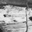
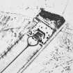
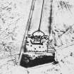
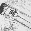
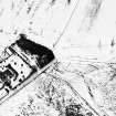
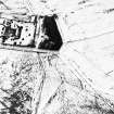
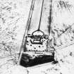
(Formerly classified as farmstead). Nothing is now visible of Mains of Skellater farmsteading, which was situated 70m NW of Skellater House (NJ31SW 6.00), but was demolished and removed in recent times. On the 1st edition Ordnance Survey 6-inch map (Aberdeenshire, 1869, sheet lxix) the farmsteading is depicted as a long range aligned from NNE and SSW, accompanied by two other buildings set a short distance to the SE of the SSW end. A similar arrangement is depicted on the 2nd edition of the map (1902, sheet lxix), but by then the long range had been split into two buildings of equal length.
Visited by RCAHMS (PC), 18 June 1997.

