Accessibility

Font Size

100% 150% 200%

Background Colour

Default Contrast
Close Reset

Boddam, Buchan Ness Lighthouse

Lighthouse (19th Century)

Site Name Boddam, Buchan Ness Lighthouse

Classification Lighthouse (19th Century)

Alternative Name(s) Boddam; Buchanness Lighthouse

Canmore ID 120265

Site Number NK14SW 73

NGR NK 13624 42263

Datum OSGB36 - NGR

Permalink http://canmore.org.uk/site/120265

Ordnance Survey licence number AC0000807262. All rights reserved.
Canmore Disclaimer. © Bluesky International Limited 2025. Public Sector Viewing Terms

Toggle Aerial | View on large map

Digital Images

General view of Buchan Ness lighthouse and pier, Boddam.
General view of Buchan Ness lighthouse and pier, Boddam.Buchan Ness Lighthouse, Boddam.  Oblique aerial photograph taken facing east.  This image has been produced from a print.Buchan Ness Lighthouse and Boddam.  Oblique aerial photograph taken facing north-west.  This image has been produced from a print.Boddam, showing Buchan Ness Lighthouse Peterhead, Aberdeenshire, Scotland. Oblique aerial photograph taken facing East. Boddam, Buchan Ness Lighthouse
View from west over concrete bridge to island (built 1963), showing lighthouse and compoundBoddam, Buchan Ness Lighthouse
View from north west of lighthouse and compound, with concrete bridge to island (built in 1963) in foregroundBoddam, Buchan Ness Lighthouse
View from south west of lighthouse, and concrete bridge (built 1963) to island on which lighthouse is situated, to the east of the village of BoddamOblique aerial view centred on the lighthouse with the school and churches adjacent, taken from the W.Buchan Ness Lighthouse
General ViewBuchan Ness Lighthouse, Boddam.  Oblique aerial photograph taken facing south-west.  This image has been produced from a print.Boddam, Buchan Ness Lighthouse
Distant view from south west of lighthouseBoddam, Buchan Ness Lighthouse
View from west of lighthouse and adjacent keepers' housesOblique aerial view centred on the lighthouse and road bridge, taken from the SSW.Boddam, Buchan Ness Lighthouse
View of lighthouse from west, through gate to compoundBoddam, Buchan Ness Lighthouse
View from north west of lighthouse and adjacent keepers' housesOblique aerial view of Peterhead Power Station under construction, Boddam village and Buchan Ness lighthouse.Boddam, Buchan Ness Lighthouse
Distant view from south west of lighthouseOblique aerial view of Boddam village, Buchan Ness Lighthouse and Peterhead power station, taken from the SE.Oblique aerial view centred on the lighthouse and road bridge, taken from the SE.Oblique aerial view centred on the lighthouse and road bridge, taken from the ESE.Boddam, Buchan Ness Lighthouse
View from south west of lighthouse, and concrete bridge (built 1963) to island on which lighthouse is situated, to the east of the village of BoddamOblique aerial view of Peterhead Power Station under construction, Boddam village and Buchan Ness lighthouse.Boddam, Buchan Ness Lighthouse
View of lighthouse from west, through gate to compoundBoddam, Buchan Ness Lighthouse
View from north west of lighthouse and compound, with concrete bridge to island (built in 1963) in foregroundBoddam, Buchan Ness Lighthouse
View from north west of lighthouse and adjacent keepers' housesBoddam, Buchan Ness Lighthouse
View from north west of lighthouse and compound, with concrete bridge to island (built in 1963) in foregroundBoddam, Buchan Ness Lighthouse
View from north west of lighthouse and adjacent keepers' housesBoddam, Buchan Ness Lighthouse
View from west of lighthouse and adjacent keepers' housesGeneral oblique aerial view looking across the barracks, houses and village towards the lighthouse, taken from the W.Buchan Ness Lighthouse, Boddam.  Oblique aerial photograph taken facing north-east.  This image has been produced from a print.Boddam, Buchan Ness Lighthouse
View from west of lighthouse and adjacent keepers' housesOblique aerial view centred on the lighthouse with the school and churches adjacent, taken from the W.Boddam, Buchan Ness Lighthouse
View from west over concrete bridge to island (built 1963), showing lighthouse and compoundBoddam, Buchan Ness Lighthouse
View of lighthouse from west, through gate to compound

Administrative Areas

  • Council Aberdeenshire
  • Parish Peterhead
  • Former Region Grampian
  • Former District Banff And Buchan
  • Former County Aberdeenshire

Archaeology Notes

NK14SW 73.00 13624 42263

Lighthouse [NAT]

OS 1:10,000 map, 1983.

NK14SW 73.01 NK 1350 4231 access bridge

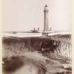
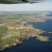
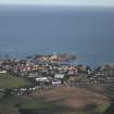
(Location cited as NK 137 423). Buchan Ness Lighthouse. Built 1827, engineer Robert Stevenson. A tall tower with lantern 130ft (39.6m) above sea level, painted in red and white stripes, with a walkway supported on corbles with arched openings. There are two blocks of ancillary buildings (one of them flat-roofed) and the tower itself rises from a circular one-storey base. On an island, connected to the shore by a 3-span concrete bridge.

J R Hume 1977.

As built, Buchan Ness was fitted with the first flashing light in a Scottish lighthouse. It received a dioptric light system (with an enlarged lantern to allow cleaning) in 1910, was electified in 1978, and has been fitted with a Racon beacon.

D B Hague and R Christie 1975; R W Munro 1979; K Allardyce and E M Hood 1986.

Air photographs: AAS/94/18/G38/29-30.

NMRS, MS/712/21.

Aside from a lighthouse, this complex also includes a concrete bridge, built 1963, linking the island to the main land and a row of keepers' cottages. A RCAHMS photographic survey was carried out, during February 1998, in order to enhance the National Monuments Record of Scotland holdings.

Visited by RCAHMS (MKO), February 1998.

Activities

Construction (1827)

Light established 1827.

J R Hume 1977

Incident (1939 - 1945)

Slight damage to tower and dwelling houses as a result of a mine explosion during WW2.

K Allardyce and E M Hood 1986

Publication Account (2007)

Buchan Ness Lighthouse

The light at this lighthouse on the coast at Boddam, built for the Northern Lighthouse Board, was first exhibited in 1827 at a height of about 130 ft above high-water level.

The circularmasonry to wer, 118 ft highwith 166 steps, and light keepers’ accommodation, was designed by Robert Stevenson and built by contractor John Gibb. In 1907, on the instructions of David A. Stevenson, a broad red band was painted on the tower to distinguish it as a day mark.

Stevenson’s ‘twinkling’ light, produced from an array of Argand burners with silvered copper reflectors revolvingmore quickly than any previous light, was a success. In 1879 Lord Kelvin considered it one of the three best

revolving lights in the world. In order to accommodate a dioptric lens in 1910 a sector of the lantern had to be projected out in the form of shallow bay.

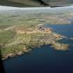
The lighthouse station is situated on a rocky promontory which was at one time an island and in 1834 was connected to Boddam by means of a timber bridge with nine spans of about 20 ft. The bridge was about 17 ft high and 8 ft wide and was erected by John Gibb under Stevenson’s direction for about £200.

R Paxton and J Shipway, 2007.

Reproduced from 'Civil Engineering heritage: Scotland - Highlands and Islands' with kind permission from Thomas Telford Publishers.

Field Visit (October 2022)

NK 13624 42263 Visited during fieldwork by SCAPE. No changes to description.

Information from S. Boyd and J. Hambly - Scottish Coastal Archaeology and the Problem of Erosion (SCAPE)

References

MyCanmore Image Contributions


Contribute an Image

MyCanmore Text Contributions