
Dunan Diarmid


Dun (Period Unassigned)
Site Name Dunan Diarmid
Classification Dun (Period Unassigned)
Canmore ID 12016
Site Number NG92SW 1
NGR NG 9395 2071
Datum OSGB36 - NGR
Permalink http://canmore.org.uk/site/12016


- Council Highland
- Parish Kintail
- Former Region Highland
- Former District Skye And Lochalsh
- Former County Ross And Cromarty
NG92SW 1 9395 2071.
(NG 9395 2071) Dunan Diarmaid (NR) (In Ruins)
OS 6" map, Ross-shire, 2nd ed., 1906.
A dun consisting of an oval wall spread in ruin to a thickness of about 15'. The interior measures about 55' x 25', and the entrance may have been in the S. The 'Diarmaid' of the name, and of the nearby 'Diarmaid's Grave' (NG92SW 2) is the Fingalian hero.
L Bogle 1895; R W Feachem 1963.
Dunan Diarmid (NR)
OS 1:10,000 map, (1971)
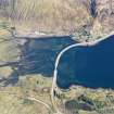
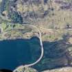
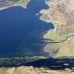
Dunan Diarmid, the remains of a dun occupying the level summit of an isolated rocky knoll. Oval on plan, the dun measures 24.5m E-W by 16.0m N-S within a wall c. 2.5m thick, reduced to a stony scarp with a few stones of the outer face visible intermittently around the W half. A deep hollow at the modern S approach probably denotes the mutilated entrance. In the interior in the NE, is a modern enclosure, 6.0m E-W by 7.0m N-S within a wall 0.8m thick.
Surveyed at 1:2500. (Visited by OS (R L) 22 September 1966).
Visited by OS (A A) 13 June 1974.
Note (23 January 2015 - 15 August 2016)
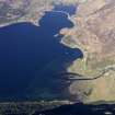
This small fortification occupies a rocky hillock at the seaward end of a spit projecting from the N shore of Loch Duich at the mouth of Strath Croe. Roughly oval on plan, it measures about 24m from E to W by 16m transversely within a wall reduced to a stony scarp. A few outer facing-stones are visible on the W and the entrance is probably marked by a gap on the SSW. The only feature in the interior is a relatively recent walled enclosure on the E.
Information from An Atlas of Hillforts of Great Britain and Ireland – 15 August 2016. Atlas of Hillforts SC2748

