
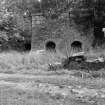
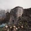
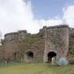
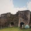
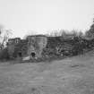
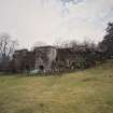
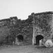
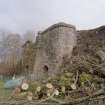
Mains Of Midstrath, Limekiln


Lime Kiln (Period Unassigned)
Site Name Mains Of Midstrath, Limekiln
Classification Lime Kiln (Period Unassigned)
Alternative Name(s) Midstrath Limekiln
Canmore ID 120083
Site Number NO59NE 62.01
NGR NO 58768 95305
Datum OSGB36 - NGR
Permalink http://canmore.org.uk/site/120083


- Council Aberdeenshire
- Parish Birse
- Former Region Grampian
- Former District Kincardine And Deeside
- Former County Aberdeenshire
NO59NE 62.01 58768 95305
Lk (dis) [NAT]
OS 1:10,000 map, 1982.
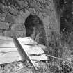
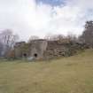
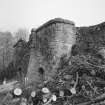
(Location cited [incorrectly] as NJ 588 952 and name as Midstrath Limekiln). 19th century. a Single 3-draw limekiln, with the side draw-holes approached through tunnels from the front face of the kiln. The tunnels and central drawholes have semicircular arches.
J R Hume 1977.

