
Scheduled Maintenance
Please be advised that this website will undergo scheduled maintenance on the following dates: •
Tuesday 3rd December 11:00-15:00
During these times, some services may be temporarily unavailable. We apologise for any inconvenience this may cause.
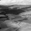
Cockbridge Farm


Farmhouse (Period Unassigned), Farmstead (Period Unassigned), Hut(S) (Period Unassigned)
Site Name Cockbridge Farm
Classification Farmhouse (Period Unassigned), Farmstead (Period Unassigned), Hut(S) (Period Unassigned)
Alternative Name(s) Corgarff; The Cock
Canmore ID 119961
Site Number NJ20NE 35
NGR NJ 2576 0880
NGR Description NJ 2576 0880 and NJ 2581 0881
Datum OSGB36 - NGR
Permalink http://canmore.org.uk/site/119961


- Council Aberdeenshire
- Parish Strathdon
- Former Region Grampian
- Former District Gordon
- Former County Aberdeenshire
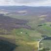
The footings of two buildings and three huts are visible on the haughland of the Cock Burn to the south of the present buildings of Cockbridge Farm. The farm was known as The Cock until the beginning of the twentieth century.
The two buildings are depicted as roofed on the first edition of the OS six-inch map and were the most southerly of a dispersed group of five buildings forming the farmstead of The Cock. The smaller of the two has an adjoining enclosure, which is not shown on the map, but by 1902, only the larger building is depicted. The huts lie further to the south, two at the eastern edge of the haughland, but are not shown on either editions of the map.
Text prepared by RCAHMS as part of the Accessing Scotland's Past project
NJ20NE 35 2576 0880 and 2581 0881
Little now survives of the buildings of Cockbridge Farm, or The Cock as it was known until the beginning of this century (OS 6-inch map, 2nd edition, Aberdeenshire 1902, sheet lxviii). In 1869, the farmstead was represented by a dispersed group of buildings (OS 6-inch map, 1st edition, Aberdeenshire, 1869, sheet lxviii), most of which had either been removed or altered by 1902.
The footings of up to five structures are visible on the haughland of the Cock Burn to the S of the present farm buildings; two of them can be identified as buildings depicted on the 1st edition of the map.
NJ 2575 0875. This building is trapezoidal on plan and measures about 17.2m from NE to SW by 8.4m in breadth at the NE end and 4.4m at the SW end over heavily robbed-out footings. There is a possible entrance at the NE end of the NW side and a small outshot is attached to the SW end of the NW side. A few meters to the SW (NJ 2573 0873) there are the poorly-defined footings of what was a building with an enclosure attached to its SE side and, immediately beyond it to the SW, there are the footings of a small hut or pen. A little further to the S, at the eastern edge of the haughland, there are two huts, neither of which have been mapped previously. The south-westerly of the pair (NJ 2572 0867) measures 9.7m in length from NE to SW by 6m overall. On the SE side, where the structure has been levelled into the natural slope, the scarp has been revetted, but elsewhere there is a low grass-grown bank 1.2m thick and 0.3m high. The entrance is on the NW.
The second hut (NJ 2573 0867) lies 10m NE of the first and is also subrectangular on plan. It measures 5.4m from NE to SW by 4.9m over grass-grown banks up to 1.5m thick and 0.2m high, and the entrance is on the NW.
Visited by RCAHMS (JRS), 22 May 1997.

