
Following the launch of trove.scot in February 2025 we are now planning the retiral of some of our webservices. Canmore will be switched off on 24th June 2025. Information about the closure can be found on the HES website: Retiral of HES web services | Historic Environment Scotland
Skye, Glasnakille


Head Dyke (Post Medieval), Township (Period Unassigned)
Site Name Skye, Glasnakille
Classification Head Dyke (Post Medieval), Township (Period Unassigned)
Alternative Name(s) Strathaird Estate
Canmore ID 119728
Site Number NG51SW 8
NGR NG 540 132
NGR Description NG 540 132 to NG 531 119
Datum OSGB36 - NGR
Permalink http://canmore.org.uk/site/119728


- Council Highland
- Parish Strath
- Former Region Highland
- Former District Skye And Lochalsh
- Former County Inverness-shire
NG51SW 8 540 132 to 531 119
A township, comprising one roofed building, three unroofed buildings and three lenghts of head-dyke is depicted on the 1st edition of the OS 6-inch map (Inverness-shire, Isle of Skye 1881, sheet L). A crofting township of twenty-five roofed and two unroofed buildings is shown on the current edition of the OS 1:10000 map (1986).
Information from RCAHMS (AKK) 18 November 1996.
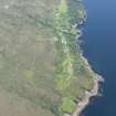
Site recorded in the spring of 1997, during a field survey carried out by Martin Wildgoose and associates on part of the John Muir Trust's Strathaird Estate. The surveyed portion lies to the S and E of Bla Bheinn, some 3000ha of undulating lowland terrain lying between the coast and the Cuillin mountains.
NG 5368 1299 ?Longhouse foundations.
A full report is lodged with the John Muir Trust. A fuller summary is lodged with the NMRS.
Sponsor: John Muir Trust.
K Miller 1998

