
Following the launch of trove.scot in February 2025 we are now planning the retiral of some of our webservices. Canmore will be switched off on 24th June 2025. Information about the closure can be found on the HES website: Retiral of HES web services | Historic Environment Scotland
Lunna, Chapel Knowe


Building (Medieval), Chapel (Medieval), Enclosure (Prehistoric), Font (Medieval)(Possible), Kiln (Medieval)(Possible)
Site Name Lunna, Chapel Knowe
Classification Building (Medieval), Chapel (Medieval), Enclosure (Prehistoric), Font (Medieval)(Possible), Kiln (Medieval)(Possible)
Alternative Name(s) Lunna House
Canmore ID 1194
Site Number HU46NE 4
NGR HU 4854 6913
Datum OSGB36 - NGR
Permalink http://canmore.org.uk/site/1194


- Council Shetland Islands
- Parish Nesting
- Former Region Shetland Islands Area
- Former District Shetland
- Former County Shetland
HU46NE 4 4855 6910
For adjacent Lunna church, see HU46NE 9.
(HU 4853 6914) Chapel Knowe: Monastery (NR) (Site of)
OS 6" map, Shetland, 2nd ed., (1903).
Nothing definite can be learned but it is generally supposed to have been the site of a monastery.
Name Book 1878.
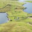
The summit of Chapel Knowe is enclosed by the much-reduced remains of an earth-and-stone rampart, still up to 6ft broad and 3ft high.
The enclosure so formed, entered from the north, measures 28 yards N-S by 20 yards E-W and is bisected by a N-S wall on an outcrop of rock. The eastern half appears to be lower than the western half and may have been scooped.
On the west side of the western half are the foundations of a rectangular building measuring 27ft 9 ins. by 12ft 9 ins. over walls about 2ft thick, apparently the "foundation" of the old church of the parish " seen by Muir in 1863 (T S Muir 1885) described by him as some 28ft in length and as having been built on a site of older occupation "as these are the remains of a burgh quite close to its south side". Early Iron Age potsherds havebeen found on the site.
A broken font was discovered among the ruins (S Hibbert 1822).
Another rectangular building, measuring about 40ft by 10ft overall, evidently stood outside the east rampart.
Both buildings run ENE to WSW.
RCAHMS 1946.
The enclosure measures 40 yds. N-S and E-W. The entrance, in the ENE, is 7 yds. wide. The bank is about 4ft high. The interior is very uneven and the dividing wall almost certainly natural, as is the hollowing of the E. enclosure.
The church measures 28ft 2 ins. by 12ft 9 ins. The second building is about 55ft long by 11ft 6 ins.wide but the W.end is uncertain. There is a cross-wall c.8ft in from the E.end, which appears to be apsidal.
Other (possible) structures in and on the perimeter of the enclosure may be natural.
A MacDonald Ms, 28th August 1967.
The footings of two buildings and the remains of an enclosure wall, generally as described by MacDonald.
A circular hollow c.5.6m in diameter and 1.4m deep, possibly a kiln, lies at the W. end of the second building and may be associated with it. There is no evidence of any other structures.
Surveyed at 1/2500.
Visited by OS (RL) 31 May 1968.
Scheduled as Chapel Knowe, ecclesiastical and earlier remains.
Information from Historic Scotland, scheduling document dated 1 December 2000.
Field Visit (7 July 1930)
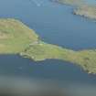
Buildings, Chapel Knowe. Some slight remains of buildings survive on the Chapel Knowe, a rocky grass-covered knoll on the narrow isthmus between East and West Lunna Voes. The summit of the hillock is enclosed by a rampart of earth and stone, now considerably wasted and reduced, but still 6 ft. broad and 3 ft. high where it is best preserved. The irregularly shaped enclosure so formed is entered from the N., and measures 23 yds. from N. to S. by 20 yds. from E. to W. It has been divided into two almost equal parts by a wall running N. and S. on an outcrop of rock. The E. division lies below the level of the other, as if the ground had been partly excavated. On the W. side of the higher division can be traced the foundations of a rectangular building, measuring 27 ft. 9 in. by 12 ft. 9 in. over walls about 2 ft. in thickness, apparently ‘the foundation of the old church of the parish’, seen by Muir in 1863. He continues: ‘It seems to have been only some twenty-eight feet in length, and erected on ground more anciently occupied, as there are the remains of a burgh quite close to its south side’ (1). Hibbert likewise remarks that: ‘Near the Isthmus of Lunna, once stood a religious building, but of what description is very doubtful: a broken font was discovered among the ruins, as well as architectural carvings, executed in…Kleber’ (2). Another rectangular building, measuring about 40 ft. by 10 ft. overall, evidently stood outside the E. rampart. Both of these structures ran E.N.E. and W.S.W.
Although this site is identified upon the O.S. map as that of a monastery, it has yielded pieces of Early Iron Age pottery and must therefore be considered as being of pre-historic origin. A whorl of steatite was recently found in a rabbit burrow.
RCAHMS 1946, visited 7 July 1930.
(1) Muir, Ecclesiastical Notes on Some of the Islands of Scotland, p. 174.
(2) Description of the Shetland Islands, p. 294. ‘Kleber’ is steatite.
OS 6" map, Shetland, 2nd ed., (1903) (" Monastery, Site of ").

