
Scheduled Maintenance
Please be advised that this website will undergo scheduled maintenance on the following dates: •
Tuesday 3rd December 11:00-15:00
During these times, some services may be temporarily unavailable. We apologise for any inconvenience this may cause.
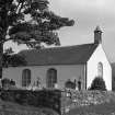
Plockton, Innes Street, Plockton Church And Burial Ground


Burial Ground (19th Century), Church (19th Century), Storehouse (19th Century)
Site Name Plockton, Innes Street, Plockton Church And Burial Ground
Classification Burial Ground (19th Century), Church (19th Century), Storehouse (19th Century)
Alternative Name(s) Telford Church; Church Of Scotland; Plockton Church (Church Of Scotland) And Graveyard Including Drystone Wall
Canmore ID 11906
Site Number NG83SW 4
NGR NG 80279 33303
Datum OSGB36 - NGR
Permalink http://canmore.org.uk/site/11906


- Council Highland
- Parish Lochalsh
- Former Region Highland
- Former District Skye And Lochalsh
- Former County Ross And Cromarty
Most of Plockton's public buildings are in Innes Street:
Plockton High School, Shearer and Annand for Ross & Cromarty County Council, 1964, a complex of flat-roofed blocks lying long and low above the village, with later extensions of 1969 and 1980.
Primary School, Alexander Ross, 1858, a pretty contrast in Ross's simple gothic style, reminiscent of his Episcopal churches in the Highlands; corrugated iron annex, probably 1889. Church of Scotland, William Thomson, 1825-7, a harled Parliamentary church with a panelled gallery filling much of its T-plan interior; pierced wooden ceiling a later addition. Contemporary manse, James Smith's single-storey, shallow U-plan design. Free Church, c.1845, refitted and improved by Alexander Ross, 1869; converted to flats in a reprieve from proposed demolition by Philip Cocker Assocs, 1993. The long street elevation of this double-gabled building was previously blind except for the entrance, which is now flanked by pairs of long lights reminiscent of the ventilation slits that are a feature of local barns.
Taken from "Western Seaboard: An Illustrated Architectural Guide", by Mary Miers, 2008. Published by the Rutland Press http://www.rias.org.uk

NG83SW 4 80279 33303
Plockton Church [NAT]
OS (GIS) MasterMap, November 2009.
For associated manse (NG 8030 3334), see NG83SW 74.
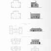
Standing Building Recording (October 2015)
NG 80296 33297 A Level 1 historic building survey was carried out in October 2015 of the Plockton Harbour CIC Equipment Store, prior to its demolition. The buildings appear to have been constructed between 1875 and 1904 as an addition to the Telford Church, and are first shown on the 2nd Edition OS map of the area. At the time of survey the store consisted of a single-storey timber-framed building of c28m2 and a second of c15m2, both in a dilapidated condition. These abutted one another at their S and N gable ends respectively.
Archive: National Record of the Historic Environment (NRHE) intended
Funder: The National Trust for Scotland
Sam Williamson and Michael Sharpe – AOC Archaeology Group
(Source: DES, Volume 16)

