
Pricing Change
New pricing for orders of material from this site will come into place shortly. Charges for supply of digital images, digitisation on demand, prints and licensing will be altered.
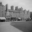
Edinburgh, 16 & 19 Bristo Street, Seceder's Land


Shop (19th Century), Tenement (18th Century)
Site Name Edinburgh, 16 & 19 Bristo Street, Seceder's Land
Classification Shop (19th Century), Tenement (18th Century)
Canmore ID 119022
Site Number NT27SE 1596
NGR NT 25855 73124
Datum OSGB36 - NGR
Permalink http://canmore.org.uk/site/119022


- Council Edinburgh, City Of
- Parish Edinburgh (Edinburgh, City Of)
- Former Region Lothian
- Former District City Of Edinburgh
- Former County Midlothian
NMRS REFERENCE:
Edinburgh, 16-19 Bristo Street, Seceder's Land which was Category B listed was demolished in January 1968.
Listed in NMRS Demolitions catalogue.

