
Pricing Change
New pricing for orders of material from this site will come into place shortly. Charges for supply of digital images, digitisation on demand, prints and licensing will be altered.
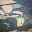
Mains Of Aboyne


Enclosure (Period Unassigned)
Site Name Mains Of Aboyne
Classification Enclosure (Period Unassigned)
Alternative Name(s) Aboyne Castle Policies
Canmore ID 118906
Site Number NO59NW 49
NGR NO 525 993
Datum OSGB36 - NGR
Permalink http://canmore.org.uk/site/118906


- Council Aberdeenshire
- Parish Aboyne And Glentanar
- Former Region Grampian
- Former District Kincardine And Deeside
- Former County Aberdeenshire
NO59NW 19 525 993
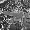
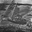
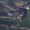
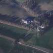
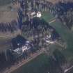
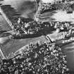
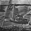
Air photography (CUCAP CDE 82, dated 20 July 1977 and AAS/95/09/G26/11-12, dated 28 August 1995) has recorded a large rectilinear enclosure cut by a track.
NMRS, MS/712/19.

