
Am Baghan Burblach


Fort (Period Unassigned)
Site Name Am Baghan Burblach
Classification Fort (Period Unassigned)
Canmore ID 11880
Site Number NG82SW 9
NGR NG 8315 2001
Datum OSGB36 - NGR
Permalink http://canmore.org.uk/site/11880


- Council Highland
- Parish Glenelg (Skye And Lochalsh)
- Former Region Highland
- Former District Skye And Lochalsh
- Former County Inverness-shire
NG82SW 9 8315 2001.
(NG 8315 2001) Am Baghan (NR) (Remains of Pictish Fort)
Am Baghan Burblach (Baghan - generic word for earth-work 'Burblach' place-name) is a boat-shaped enclosure, 170' x 100' with entrances W and E, (L Bogle 1895) surrounded by a wall 11' thick. The interior contains a circular enclosure 40' in diameter, a ruined cottage and other foundations, all of which are of comparitively recent date.
Feachem (R W Feachem 1963) refers to it as a fort.
L Bogle 1895; R W Feachem 1963.
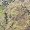
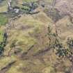
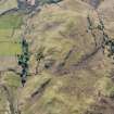
An oval fort measuring 57.0m NW-SE by 30.0m NE-SW within a tumbled wall varying between 3.0m and 3.8m in thickness. It has two opposing entrances, in the NW and SE, both partially obscured by debris. Within the wall in the SW is a well-built wall face standing to two courses at right angles to the line of the wall. It is 1.2m long and 0.6m high and seemingly isolation, not being part of any internal structure as far as can be ascertained. A heavy growth of bracken obscures most of the interior, but the ruinous modern building in the NW is quite evident, and the E arc of the large circular enclosure planned by Bogle (L Bogle 1895) can be traced, although there is no sign of the two smaller circles. In the vicinity of the latter, however, are traces of a curving wall of uncertain date and purpose.
Resurveyed at 1:10,000.
Visited by OS (A A), 19 June 1974.
Note (20 January 2015 - 30 May 2016)
This small fortification is situated on a hillock forming the summit of a spur on the N slopes of Glen More to the NE of Glenelg. Oval on plan, it measures 57m from NW to SE by 30m transversely (0.13ha) within a wall between 3m and 3.8m in thickness. Long runs of the outer face can be seen around the SE half of the circuit and adjacent to the entrance on the NW, while the inner face can be seen also at the NW entrance and at a second entrance on the SE; a sketch-plan drawn up by Lockhart Bogle about 1895 appears to show an intermediate wall-face within the thickness of the wall to the NE of the SE entrance, but the purpose of a wall-face within the body of the wall on the WSW but at right-angles to its line is unclear. The footings of a rectangular building of comparatively recent date lie at the NW end of the interior, and at the SE end at least one circular enclosure some 12m in diameter; the latter was ruinous and grass-grown by about 1895 (Bogle 1895,185), and appeared sufficiently ancient in 1872 that Sir Henry Dryden included it on his plan (RCAHMS IND 241/1).
Information from An Atlas of Hillforts of Great Britain and Ireland – 30 May 2016. Atlas of Hillforts SC2724

