
Following the launch of trove.scot in February 2025 we are now planning the retiral of some of our webservices. Canmore will be switched off on 24th June 2025. Information about the closure can be found on the HES website: Retiral of HES web services | Historic Environment Scotland
Edinburgh, Drummond Street, Flodden Wall


Wall (16th Century)
Site Name Edinburgh, Drummond Street, Flodden Wall
Classification Wall (16th Century)
Alternative Name(s) Edinburgh Town Wall
Canmore ID 118754
Site Number NT27SE 1571
NGR NT 26199 73414
Datum OSGB36 - NGR
Permalink http://canmore.org.uk/site/118754


- Council Edinburgh, City Of
- Parish Edinburgh (Edinburgh, City Of)
- Former Region Lothian
- Former District City Of Edinburgh
- Former County Midlothian
NT27SE 1571 26199 73414
NT27SE 1658 NT 26238 73483 Flodden Wall (Pleasance)
NT27SE 3931 NT 2589 7327 Lothian Street
NT27SE 5197 NT 2527 7335 to NT 2528 7334 Johnston Terrace to Grassmarket
Scheduled (with NT27SE 1658) as 'Edinburgh Town Wall, Flodden Wall, Drummond Street to Pleasance... a stretch of the Flodden Wall, one of Edinburgh's late medieval town walls, dating to circa 1513. The stretch runs ENE along Drummond Street, from NT2613 7338 to NT 2625 7344, where it turns a right-angled corner and then runs NNW along the Pleasance to NT 2621 7352'.
Information from Historic Scotland, scheduling documment dated 4 February 2003.
Watching Brief (May 2010 - June 2010)
NT 2620 7342 A watching brief was carried out intermittently May–June 2010 during groundworks associated with the creation of a new bicycle store and the insertion of bollards. Deposits of modern made ground were recorded but no significant archaeological features or artefacts were discovered.
Archive: RCAHMS (intended)
Funder: University of Edinburgh
Lindsay Dunbar – AOC Archaeology Group
Watching Brief (8 January 2013 - 16 July 2013)
NT 2534 7350 A watching brief was carried out, 8 January – 16 July 2013, during the excavation of pipe trenches for a new central heating and power project. The development area was centred on the new energy centre at St John’s Hill, to the E of the Pleasance and involved the excavation of trenches along Drummond Street, Infirmary Street, Viewcraig Gardens and Holyrood Road.
In situ archaeological material was encountered in the High School Yards, where a tarmac car park had been laid over Georgian garden features. A structure was recorded on St John’s Hill, next to the Hutton Memorial Garden. This was thought to be the foundations of a school with associated outbuildings and yard surfaces.
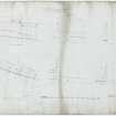
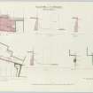
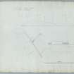
A track was also excavated up to the remains of the Flodden Wall at the W end of Drummond Street. This work recorded several phases of rebuilding within the existing wall, and phases of made ground in the area around it.
Archive: RCAHMS (intended)
Funder: University of Edinburgh
Mike Roy, AOC Archaeology Group
Jake Streatfeild-James,
2013

