
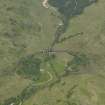
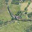
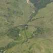
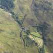
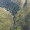
Glen House


Farmstead (Period Unassigned), Field System (Period Unassigned)
Site Name Glen House
Classification Farmstead (Period Unassigned), Field System (Period Unassigned)
Canmore ID 118507
Site Number NM98SW 3
NGR NM 9102 8136
Datum OSGB36 - NGR
Permalink http://canmore.org.uk/site/118507


- Council Highland
- Parish Arisaig And Moidart
- Former Region Highland
- Former District Lochaber
- Former County Inverness-shire
Note
A farmstead comprising one unroofed long building, two roofed buildings, an enclosure and a field-system is depicted on the 1st edition of the OS 6-inch map (Inverness-shire 1875-7, sheet cxxxvii). One partially roofed building, two enclosuresand part of the field-system are shown on the current edition of the OS 1:10000 map (1974).
Information from RCAHMS (SAH) 21 August 1996

