
Polnish


Building(S) (Period Unassigned), Kiln (Period Unassigned)(Possible), Quarry (Period Unassigned), Rig And Furrow (Medieval) - (Post Medieval)
Site Name Polnish
Classification Building(S) (Period Unassigned), Kiln (Period Unassigned)(Possible), Quarry (Period Unassigned), Rig And Furrow (Medieval) - (Post Medieval)
Canmore ID 118438
Site Number NM78SE 2
NGR NM 751 827
Datum OSGB36 - NGR
Permalink http://canmore.org.uk/site/118438


- Council Highland
- Parish Arisaig And Moidart
- Former Region Highland
- Former District Lochaber
- Former County Inverness-shire
NM78SE 2 751 827
Related sites:
NM78SW 10 centred on NM 749 825
NM78SE 13 centred on NM 7520 8254
NM78SE 2, NM78SW 10 and NM78SE 13 are all part of a dispersed settlement known locally as Lower Polnish. From map evidence, it appears that NM78SE 2 and NM78SW 10 may have formed a single township, which was already largely deserted by the time of the 1st Edition of the OS 6-inch map (Inverness-shire 1876, sheet cxxxvi). NM78SE 13 appears to have been established slightly later and remained occupied well into the twentieth century, with one building remaining roofed and occupied until the present day.
Information from RCHAMS (IM) 24 January 2011.
An unroofed building is shown on the 1st edition of the OS 6-inch map (Inverness-shire 1876, sheet cxxxvi), but it is not shown on the current edition of the OS 1:10000 map (1974).
Information from RCAHMS (SAH) 20 August 1996.
NM 752 828 to NM 729 841 During December 1995 and September 1996, a programme of evaluation and excavation was carried out in advance of the proposed widening and realignment of the A830 between Polnish Chapel and the Loch Nan Uamh viaduct.
The characteristic steep slopes and rocky terrain meant that the potential for site identification was limited. However, several features were identified during the evaluation, in two cases confirming identifications made during the desk-based study.
Sixteen trenches were excavated, all located at the W end of the road corridor in an area comprising arable flood plain (NM 7317 8410). The only feature located within the trial trenches was a large scooped feature, possibly an old stream course.
The following sites were located and recorded by fieldwalking and palaeoenvironmental assessment elsewhere within the road corridor:
1 NM 7512 8265 Post-medieval building 1.
2 NM 7509 8275 Post-medieval building 2.
3 NM 7504 8280 Possible kiln.
4 NM 7503 8280 Rig and furrow.
5 NM 7507 8270 Quarry.
Sites 1-5 clustered to the W of Polnish chapel, and together with a spread of similar structures located outside the road corridor, appear to form components of a depopulated settlement. A trial section was excavated through part of the rig system (site 4), revealing a width of 2.1m between crests.
During September 1996, excavations were conducted at sites 1, 2, 3 and 6 and a programme of peat coring was carried out.
Building 1 (site 1), noted as roofed on the OS 1st edition map, lay 50m to the S of the Roman Catholic chapel. The basal course of the walls was constructed of rough, undressed, unmortared stones. Excavation revealed that the building had been substantially altered. Although extensively robbed on its E side, there was a secondary stone trough constructed in the centre of the building filled with a deposit of material very like manure. On the W side of the building, this trough exited through the wall where there was a large flat stone in place, presumably placed there to allow the removal of manure. Other than within the N section of the building where there was an area of cobbling, any earthen floor layer appeared to have been heavily disturbed, presumably by stock animals. A varied selection of 19th-century pottery and glass was recovered from this building which is presumed of late 18th/early 19th-century origin.
Building 2 (site 2) lay c 30m to the W of Polnish RC chapel and was built in the lee of a W facing steep slope, into which the building had been constructed. Its walls were constructed from roughly dressed stones. Excavation revealed a rough floor into which, at the SW corner, longitudinal timbers had been set. The entrance lay on the E side. Continuing into the building from the entrance was a paved area constructed from large flagstones. Immediately adjoining this was a raised hearth area with the remains of a hearth in situ. The building had been constructed over a layer of peat which presumably represents the approximate ground surface during construction, but a horizontal foundation raft of large slabs had been laid below the E facing wall, increasing the width of the wall to 1m.
The possible kiln (site 3) located on the crest of the slope to the W of buildings 1 and 2 was found by excavation to comprise the remains of a circular structure 3m in diameter with unmortared rough stone walls 0.6m thick. These walls survived only to a height of 0.4-0.5m. On the N side, a narrow (0.2m wide) flue was noted; however, no trace of burning was found within the structure and thus its function remains unclear.
A Data Structure Report has been produced for the evaluation phase of the work, and a Data Structure Report for the excavations is in preparation.
Sponsor: The National Roads Directorate of The Scottish Office Development Department, managed on their behalf by Historic Scotland
A Rees 1996
Trial Trench (December 1995)
NM 752 828 to NM 729 841 During December 1995 and September 1996, a programme of evaluation and excavation was carried out in advance of the proposed widening and realignment of the A830 between Polnish Chapel and the Loch Nan Uamh viaduct.
The characteristic steep slopes and rocky terrain meant that the potential for site identification was limited. However, several features were identified during the evaluation, in two cases confirming identifications made during the desk-based study.
Sixteen trenches were excavated, all located at the W end of the road corridor in an area comprising arable flood plain (NM 7317 8410). The only feature located within the trial trenches was a large scooped feature, possibly an old stream course.
The following sites were located and recorded by fieldwalking and palaeoenvironmental assessment elsewhere within the road corridor:
1 NM 7512 8265 Post-medieval building 1.
2 NM 7509 8275 Post-medieval building 2.
3 NM 7504 8280 Possible kiln.
4 NM 7503 8280 Rig and furrow.
5 NM 7507 8270 Quarry.
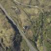
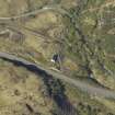
6 NM 7424 8360 Bridge and road.
Sites 1-5 clustered to the W of Polnish chapel, and together with a spread of similar structures located outside the road corridor, appear to form components of a depopulated settlement. A trial section was excavated through part of the rig system (site 4), revealing a width of 2.1m between crests.
A Data Structure Report has been produced for the evaluation phase of the work, and a Data Structure Report for the excavations is in preparation.
Sponsor: The National Roads Directorate of The Scottish Office Development Department, managed on their behalf by Historic Scotland
A Rees 1996
Pollen Analysis (December 1995)
In the area near the Roman Catholic Chapel (NM78SE 8) the deposits were penetrable using a Russian corer. A depth of 1.8m of peat was detected immediately overlying bedrock. Coring was attempted in several areas in this vicinity and the maximum depth of peat recovered was 1.8m. Evidence of peat cutting was ubiquitous in the area.
Rees 1996. MS 5478
Excavation (September 1996)
During September 1996, excavations were conducted at sites 1, 2, 3 and 6 and a programme of peat coring was carried out.
Building 1 (site 1), noted as roofed on the OS 1st edition map, lay 50m to the S of the Roman Catholic chapel. The basal course of the walls was constructed of rough, undressed, unmortared stones. Excavation revealed that the building had been substantially altered. Although extensively robbed on its E side, there was a secondary stone trough constructed in the centre of the building filled with a deposit of material very like manure. On the W side of the building, this trough exited through the wall where there was a large flat stone in place, presumably placed there to allow the removal of manure. Other than within the N section of the building where there was an area of cobbling, any earthen floor layer appeared to have been heavily disturbed, presumably by stock animals. A varied selection of 19th-century pottery and glass was recovered from this building which is presumed of late 18th/early 19th-century origin.
Building 2 (site 2) lay c 30m to the W of Polnish RC chapel and was built in the lee of a W facing steep slope, into which the building had been constructed. Its walls were constructed from roughly dressed stones. Excavation revealed a rough floor into which, at the SW corner, longitudinal timbers had been set. The entrance lay on the E side. Continuing into the building from the entrance was a paved area constructed from large flagstones. Immediately adjoining this was a raised hearth area with the remains of a hearth in situ. The building had been constructed over a layer of peat which presumably represents the approximate ground surface during construction, but a horizontal foundation raft of large slabs had been laid below the E facing wall, increasing the width of the wall to 1m.
The possible kiln (site 3) located on the crest of the slope to the W of buildings 1 and 2 was found by excavation to comprise the remains of a circular structure 3m in diameter with unmortared rough stone walls 0.6m thick. These walls survived only to a height of 0.4-0.5m. On the N side, a narrow (0.2m wide) flue was noted; however, no trace of burning was found within the structure and thus its function remains unclear.
A Data Structure Report has been produced for the evaluation phase of the work, and a Data Structure Report for the excavations is in preparation.
The road bridge (site 6) lay 110m directly SE of Polnish House and comprised part of the pre-1938 road to Mallaig. Limited excavation revealed that the bridge measures c 33 x 5.1m by 1.2m high. The bridge was constructed from large, roughly dressed and unmortared stones of varying size incorporating a small culvert. The tarmac surface of the road survives in places.
A Data Structure Report has been produced for the evaluation phase of the work, and a Data Structure Report for the excavations is in preparation.
Sponsor: The National Roads Directorate of The Scottish Office Development Department, managed on their behalf by Historic Scotland
A Rees 1996

